

 This rugged landscape at approx. 1100-1400 m asl. is the result of millions of years of chemical and...") Torcal de Antequera | Karst landscape
Torcal de Antequera | Karst landscape This rugged landscape at approx. 1100-1400 m asl. is the result of millions of years of chemical and...") Torcal de Antequera | Karst landforms
Torcal de Antequera | Karst landforms This rugged landscape at approx. 1100-1400 m asl. is the result of millions of years of chemical and...") Torcal de Antequera | Karst landscape
Torcal de Antequera | Karst landscape This rugged landscape at approx. 1100-1400 m asl. is the result of millions of years of chemical and...") Torcal de Antequera | Karst landforms
Torcal de Antequera | Karst landforms View from the slopes of the Torcal de Antequera in SE direction. This part of the Betic Cordillera c...") Villanueva de la Concepción | Rural landscape
Villanueva de la Concepción | Rural landscape View from the road A-343. This part of the Betic Cordillera consists of a mosaic of different types ...") Valle de Abdalajís | Rural landscape
Valle de Abdalajís | Rural landscape View from Sierra Elvira in SE direction to Albolote in the centre and Granada in the background of t...") Granada | Torreón de Albolote and Sierra Nevada
Granada | Torreón de Albolote and Sierra Nevada Panoramic view from Torreón de Albolote in SE direction to Granada in the background, in front of t...") Granada with Sierra Nevada
Granada with Sierra Nevada View from Torreón de Albolote in SE direction to Granada in the background, in front of the snow-ca...") Granada with Sierra Nevada
Granada with Sierra Nevada View from Torreón de Albolote in SE direction to Granada in the background, in front of the snow-ca...") Granada with Sierra Nevada
Granada with Sierra Nevada View from Torreón de Albolote in SE direction to Granada in front of the snow-capped Sierra Nevada....") Granada with Sierra Nevada
Granada with Sierra Nevada View from Plaza Mirador de San Nicolás in SE direction. The Alhambra represents a complex of palace...") Granada | Alhambra and Sierra Nevada
Granada | Alhambra and Sierra Nevada View from Plaza Mirador de San Nicolás in SE direction. The Alhambra represents a complex of palace...") Granada | Alhambra and Sierra Nevada
Granada | Alhambra and Sierra Nevada Panoramic view from the top of the sandstone cliffs of Ronda in NW direction down to the valley of t...") Ronda with sandstone cliff
Ronda with sandstone cliff Panoramic view from the top of the sandstone cliffs of Ronda in SW direction down to the valley of t...") Serranía de Ronda
Serranía de Ronda View from Road A-369 in SW direction. This very small settlement with less than 200 inhabitants repr...") Serranía de Ronda with Atajate
Serranía de Ronda with Atajate View from Road A-369. This small settlement with a few hundred inhabitants represents another exampl...") Serranía de Ronda with Benadalid
Serranía de Ronda with Benadalid View from the Sierra Bermeja (road MA-557 at the junction with the road towards Pico de los Reales) ...") Serranía de Ronda with Genalguacil and Algatocín
Serranía de Ronda with Genalguacil and Algatocín View from the Sierra Bermeja (road MA-557 at the junction with the road towards Pico de los Reales) ...") Serranía de Ronda
Serranía de Ronda Spanish fir on the slopes of the Pico de los Reales at approx. 1200 m asl. Its natural occurrence is...") Sierra Bermeja | Abies pinsapo
Sierra Bermeja | Abies pinsapo Forest of Pinus pinaster growing on the peridotite of the Pico de los Reales at approx. 1300 m asl. ...") Sierra Bermeja | Pine forest
Sierra Bermeja | Pine forest Peridotite rock forming the slopes of the Pico de los Reales at approx. 1250 m asl. The Sierra Berme...") Sierra Bermeja | Peridotite rock
Sierra Bermeja | Peridotite rock View from the access road to Pico de los Reales in NW direction. The forest in the foreground of the...") Sierra Bermeja with pine forest
Sierra Bermeja with pine forest View from the slopes of Pico de los Reales over the Campo de Gibraltar in SW direction. The monolith...") Campo de Gibraltar with Gibraltar
Campo de Gibraltar with Gibraltar View from the slopes of Pico de los Reales over the Campo de Gibraltar in SW direction. The monolith...") Gibraltar with Strait of Gibraltar
Gibraltar with Strait of Gibraltar Late afternoon view in SE direction. The Rock of Gibraltar (426 m) represents a monolithic limestone...") La Línea de la Concepción | Marina with Gibraltar
La Línea de la Concepción | Marina with Gibraltar View from the entrance area to the Great Siege Tunnels (British Overseas Territory of Gibraltar) in ...") La Línea de la Concepción
La Línea de la Concepción Panoramic view from the entrance area to the Great Siege Tunnels in N direction to the Gibraltar Int...") Gibraltar Airport and La Línea de La Concepción
Gibraltar Airport and La Línea de La Concepción View from the upper part of the Mediterranean Steps along the E slope of the Rock of Gibraltar in N ...") Gibraltar | Rock of Gibraltar
Gibraltar | Rock of Gibraltar View from O'Hara's Battery along the E slope of the Rock of Gibraltar in N direction. This monolithi...") Gibraltar | Rock of Gibraltar
Gibraltar | Rock of Gibraltar View from the top station of the cable car along the crest of the Rock of Gibraltar in N direction. ...") Gibraltar | Panoramic view with Rock of Gibraltar
Gibraltar | Panoramic view with Rock of Gibraltar") Valle del Río Papallacta | Cloud forest
Valle del Río Papallacta | Cloud forest Patches of Polylepis sp. forest alternate with the tussock grassland of the páramo.") Paso de Papallacta | Forest patches
Paso de Papallacta | Forest patches View from Highway E35 towards N") Valle del Río Chota
Valle del Río Chota The inactive Volcán Imbabura (4630 m) is seen in the left part of the image, Otavalo in the right c...") Otavalo and Volcán Imbabura
Otavalo and Volcán Imbabura The dormant Volcán Cotacachi (4944 m) is seen in the background.") Laguna Cuicocha
Laguna Cuicocha View from Highway 35 near the town of Cayambe to the 5790 m high volcano") Volcán Cayambe
Volcán Cayambe Evening view from Cruz Loma towards NE, Volcán Cayambe (5790 m) in the central background") Volcán Cayambe
Volcán Cayambe Late afternoon view from Cruz Loma towards NE, Volcán Cayambe (5790 m) in the central background") Quito and Volcán Cayambe
Quito and Volcán Cayambe Late afternoon view from Cruz Loma to the 5704 m high stratovolcano") Volcán Antisana
Volcán Antisana Evening view from Cruz Loma towards S-SW to the highest mountain of Ecuador (distance: approx. 150 k...") Volcán Chimborazo
Volcán Chimborazo Late afternoon view from Cruz Loma towards S. The Eastern Cordillera (Volcán Cotopaxi hidden in clo...") Quito with foehn clouds
Quito with foehn clouds View from Cruz Loma towards S-SW. The Eastern Cordillera (Volcán Cotopaxi hidden in clouds) is seen...") Quito | Panorama
Quito | Panorama Late afternoon view from Cruz Loma towards S. The Eastern Cordillera (Volcán Cotopaxi, 5897 m) is s...") Quito | Panorama with foehn clouds
Quito | Panorama with foehn clouds Evening view from Cruz Loma over Quito to the Eastern Cordillera with the Volcán Cotopaxi (5897 m) ...") Quito with Volcán Cotopaxi
Quito with Volcán Cotopaxi Evening view from Cruz Loma over Quito to the Eastern Cordillera with the Volcán Cotopaxi (5897 m) ...") Quito with Volcán Cotopaxi
Quito with Volcán Cotopaxi Nighttime view from Cruz Loma over Quito to the Eastern Cordillera with the Volcán Cotopaxi (5897 m...") Quito with Volcán Cotopaxi
Quito with Volcán Cotopaxi Nighttime view from Cruz Loma over Quito towards SE to the Eastern Cordillera, Volcán Cotopaxi (589...") Quito with Volcán Cotopaxi
Quito with Volcán Cotopaxi Nighttime view from Cruz Loma over Quito towards SE to the Eastern Cordillera, Volcán Cotopaxi (589...") Quito | Panorama with Volcán Cotopaxi
Quito | Panorama with Volcán Cotopaxi Morning view from the Monumento de la Libertad to Quito (Panecillo in the left foreground). The East...") Quito | Panorama with Volcán Cotopaxi
Quito | Panorama with Volcán Cotopaxi Morning view from the Monumento de la Libertad, Volcán Cotopaxi (5897 m) in the central background") Quito with Volcán Cotopaxi
Quito with Volcán Cotopaxi Evening view from Cruz Loma to the active stratovolcano (5897 m)") Volcán Cotopaxi
Volcán Cotopaxi The slopes of the active Volcán Tungurahua (5016 m) are highly susceptible to lahar flows, threaten...") Baños | Lahar flow
Baños | Lahar flow The slopes of the active Volcán Tungurahua (5016 m) are highly susceptible to lahar flows, threaten...") Baños | Lahar flow and landslide
Baños | Lahar flow and landslide View from Highway 30") Valle del Río Pastaza
Valle del Río Pastaza View from Highway 30 near Mera to the outlet of the Río Pastaza Valley towards the Amazonian lowlan...") Valle del Río Pastaza
Valle del Río Pastaza View from Highway 491 towards NW") Ambato | Andean cultural landscape
Ambato | Andean cultural landscape View from near the road Guaranda - Babahoyo (Highway 491) towards the Pacific lowlands") Bolívar | W slopes of Andes
Bolívar | W slopes of Andes View from Highway E59. The scarcity of precipitation in the rain shade of the Cordilleras has led to...") Valle del Río Jubones | Drylands
Valle del Río Jubones | Drylands Flight Dubai - Hong Kong. View in northern direction to the Gulf of Oman with Dibba Bay. The peninsu...") Fujairah | Mountain landscape
Fujairah | Mountain landscape Flight Dubai - Hong Kong. View in northwestern direction to the coast of the Gulf of Oman with the c...") Fujairah | Coast of the Gulf of Oman
Fujairah | Coast of the Gulf of Oman Flight Dubai - Hong Kong. View in northwestern direction to the coast of the Gulf of Oman with Dibba...") Fujairah | Coast of the Gulf of Oman
Fujairah | Coast of the Gulf of Oman Pallastunturi is a group of hills rising to approx. 800 m asl. Due to the prevailing cold climate, t...") Pallastunturi | Treeline area
Pallastunturi | Treeline area Pallastunturi is a group of hills rising to approx. 800 m asl. Due to the prevailing cold climate, t...") Pallastunturi | Treeline area
Pallastunturi | Treeline area Pallastunturi is a group of hills rising to approx. 800 m asl. Due to the prevailing cold climate, t...") Pallastunturi | Hilltop area
Pallastunturi | Hilltop area Pallastunturi is a group of hills rising to approx. 800 m asl. Due to the prevailing cold climate, t...") Pallastunturi | Panoramic view
Pallastunturi | Panoramic view Pallastunturi is a group of hills rising to approx. 800 m asl. Due to the prevailing cold climate, t...") Pallastunturi | Hilltop area
Pallastunturi | Hilltop area View from the upper slopes of Saana in northwestern direction") Kilpisjärvi | Siilasjärvi
Kilpisjärvi | Siilasjärvi View from the summit area of Saana in western direction down to the Kilpisjärvi lake and the summit...") Kilpisjärvi and Malla
Kilpisjärvi and Malla Panoramic view from the summit area of Saana in western direction down to the Kilpisjärvi lake and ...") Kilpisjärvi and Malla
Kilpisjärvi and Malla Flight Vienna - Funchal, view in NW direction. Le Mont d'Or (1463 m) near the French-Swiss border is...") Jura Mountains with Mont d'Or and Lac de Saint-Point
Jura Mountains with Mont d'Or and Lac de Saint-Point Morning view from Aiguille du Midi in NW direction to the exposed sedimentary layers of the Rochers ...") Chamonix | Rochers des Fiz
Chamonix | Rochers des Fiz Morning view from Aiguille du Midi to the highest summits of the Chablais (background): Tour Salliè...") Chablais with Dents du Midi
Chablais with Dents du Midi View from Aiguille du Midi 2800 vertical metres down to the Arve Valley with Chamonix (partly shred ...") Chamonix | Panoramic view
Chamonix | Panoramic view View from Aiguille du Midi 2800 vertical metres down to the Arve Valley with Chamonix and the Aiguil...") Chamonix | Panoramic view
Chamonix | Panoramic view Rue Joseph Vallot, view in S direction. The Bossons Glacier and Dôme du Goûter (4304 m) prominentl...") Chamonix with Bossons Glacier and Mont Blanc
Chamonix with Bossons Glacier and Mont Blanc Place Balmat, view in S direction. The Bossons Glacier and Dôme du Goûter (4304 m) prominently app...") Chamonix with Bossons Glacier and Mont Blanc
Chamonix with Bossons Glacier and Mont Blanc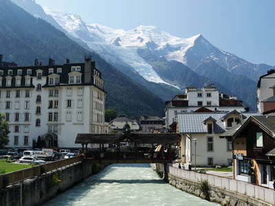 Chamonix with Bossons Glacier and Mont Blanc
 This pronounced granitic peak (3842 m) in close proximity to the summit of Mont Blanc (4806 m, visib...") Aiguille du Midi at sunrise
Aiguille du Midi at sunrise View from the upper terraces of the Aiguille du Midi (3842 m) down to Chamonix 2800 vertical metres ...") Aiguille du Midi | Lower panoramic terraces
Aiguille du Midi | Lower panoramic terraces Morning from the upper terraces of the Aiguille du Midi (3842 m) down to Chamonix 2800 vertical metr...") Aiguille du Midi | Lower panoramic terraces
Aiguille du Midi | Lower panoramic terraces Morning view from the lower terraces of Aiguille du Midi in SW direction. The most important summits...") Mont Blanc with Bossons Glacier | Panoramic view
Mont Blanc with Bossons Glacier | Panoramic view Morning view from the Aiguille du Midi in SW direction to Mont Blanc du Tacul (left side, 4248 m), M...") Mont Blanc and adjacent summits
Mont Blanc and adjacent summits Morning view from the Aiguille du Midi in SE direction. The main peaks are from left to right: Grand...") Grandes Jorasses and Mont Blanc | Panoramic view
Grandes Jorasses and Mont Blanc | Panoramic view Morning view from the Aiguille du Midi across the Glacier du Géant in SE direction to Pointe Helbro...") Glacier du Géant and Gran Paradiso
Glacier du Géant and Gran Paradiso Morning view from the Aiguille du Midi in SE direction to the 4208 m high Grandes Jorasses") Grandes Jorasses
Grandes Jorasses Morning view from the Aiguille du Midi in E direction. Some of the main summits of the Valais Alps (...") Morning view to the Valais Alps
Morning view to the Valais Alps Morning view from the Aiguille du Midi in E direction to the Valais Alps (Switzerland and Swiss-Ital...") Valais Alps | Grand Combin and Matterhorn
Valais Alps | Grand Combin and Matterhorn Morning view from the Aiguille du Midi in NE direction to Aiguille Verte (4122 m)") Aiguille Verte
Aiguille Verte View from Plan de l'Aiguille to the tongue of the Bossons Glacier. The proglacial lake is located at...") Mont Blanc with Glacier des Bossons
Mont Blanc with Glacier des Bossons View from Planpraz in S direction to Mont Maudit (left side, 4465 m), Mont Blanc (centre, 4806 m), a...") Mont Blanc with Glacier des Bossons
Mont Blanc with Glacier des Bossons View from Planpraz, a popular starting point for paragliding, in S direction to the summit of Mont B...") Mont Blanc | Summit and paragliders
Mont Blanc | Summit and paragliders This concrete arch dam - also known as Barrage de Tignes - was completed in 1952. It is part of a hy...") Barrage du Chevril and Lac du Chevril
Barrage du Chevril and Lac du Chevril Morning view of Tignes-Le-Lac (foreground) and Tignes-Val-Claret (background, in the shadow) with th...") Tignes | Panoramic view with Grande Motte
Tignes | Panoramic view with Grande Motte Morning view of an apartment building of Tignes-Le-Lac (foreground), the Lac de Tignes, and Tignes-V...") Tignes | Le-Lac and Val-Claret
Tignes | Le-Lac and Val-Claret Morning view of Lac de Tignes, Tignes-Val-Claret, and the summit of Grande Motte (3653 m). Tignes re...") Tignes | Reflections
Tignes | Reflections View from the road leading up to the Col de l'Iseran. Val d'Isère - well known for its Alpine ski r...") Val d'Isère
Val d'Isère View from the road leading up to the Col de l'Iseran in NW direction. Val d'Isère - well known for ...") Val d'Isère with Dôme de la Sache
Val d'Isère with Dôme de la Sache This mountain pass, which is a popular destination for cyclists and motorcyclists, connects the vall...") Col de l'Iseran with Pointe de Charbonnel
Col de l'Iseran with Pointe de Charbonnel View from the S side of the Col de l'Iseran in SE direction to Albaron (3638 m) in the left central ...") Haute Maurienne | Col de l'Iseran road and Graian Alps
Haute Maurienne | Col de l'Iseran road and Graian Alps View from the road leading up to the Col de l'Iseran in E direction to Bonneval-sur-Arc and the Glac...") Haute Maurienne | Bonneval-sur-Arc with Roc du Mulinet
Haute Maurienne | Bonneval-sur-Arc with Roc du Mulinet View from the road leading up to the Col de l'Iseran in E direction to Bonneval-sur-Arc and the Glac...") Haute Maurienne | Bonneval-sur-Arc with Roc du Mulinet
Haute Maurienne | Bonneval-sur-Arc with Roc du Mulinet Viewpoint near Col du Télégraphe, view in E direction down to the valley bottom of the Maurienne w...") Haute Maurienne with Saint-Michel-de-Maurienne
Haute Maurienne with Saint-Michel-de-Maurienne View from the N side of the Col du Galibier road in NE direction") Col du Galibier | Pointe d'Orient with soil erosion
Col du Galibier | Pointe d'Orient with soil erosion Panoramic view from the N side of the Col du Galibier road to an assembly of features indicating the...") Col du Galibier | Gypsum karst
Col du Galibier | Gypsum karst View from the N side of the Col du Galibier road in NE direction. The pronounced soil erosion visibl...") Col du Galibier | Northern slope
Col du Galibier | Northern slope View from the N side of the Col du Galibier road in NE direction. The pronounced soil erosion featur...") Col du Galibier | Northern slope
Col du Galibier | Northern slope View from the 2642 m high summit of the Col du Galibier in S direction towards Col du Lautaret and t...") Col du Galibier | Southern slope with Dauphiné Alps
Col du Galibier | Southern slope with Dauphiné Alps This 2057 m high mountain pass connects Grenoble with Briançon.") Col du Lautaret
Col du Lautaret The highest peak of the Dauphiné Alps (4102 m), seen from the Col du Galibier") Dauphiné Alps | Barre des Ecrins
Dauphiné Alps | Barre des Ecrins View from the ascent from Grand Parcher to the Tête d'Amont. Mont Pelvoux, with a summit elevation ...") Dauphiné Alps | Mont Pelvoux at sunrise
Dauphiné Alps | Mont Pelvoux at sunrise Morning view from the ascent from Grand Parcher to the Tête d'Amont to three prominent peaks of the...") Dauphiné Alps | Ailefroide and Mont Pelvoux
Dauphiné Alps | Ailefroide and Mont Pelvoux View from the summit area of the Tête d'Amont in NW direction over the E portion of the Ecrins mass...") Dauphiné Alps | Glacier Blanc and Pic de Clouzis
Dauphiné Alps | Glacier Blanc and Pic de Clouzis Morning view from the summit area of the Tête d'Amont in W direction across the valley of Vallouise...") Dauphiné Alps panorama
Dauphiné Alps panorama Morning view from the summit area of the Tête d'Amont in NW direction across the valley of Vallouis...") Dauphiné Alps with Vallouise
Dauphiné Alps with Vallouise Stand of mountain pine (Pinus mugo ssp. uncinata) at an elevation of approx. 2180 m (above the limit...") Tête d'Amont | Forest line area
Tête d'Amont | Forest line area Stand of mountain pine (Pinus mugo ssp. uncinata) near the forest line at an elevation of approx. 20...") Tête d'Amont | Forest line area
Tête d'Amont | Forest line area Isolated trees of mountain pine (Pinus mugo ssp. uncinata, foreground) and larch (Larix decidua, far...") Tête d'Amont | Trees above the forest line
Tête d'Amont | Trees above the forest line View from the summit area of the Tête d'Amont in NE direction down to the valley of the Durance wit...") Durance Valley with Briançon
Durance Valley with Briançon View from the summit area of the Tête d'Amont in NE direction down to the valley of the Durance wit...") Durance Valley with Briançon
Durance Valley with Briançon View from the road D954 in NE direction up the Durance Valley. This reservoir collects the discharge...") Lac de Serre-Ponçon with Pont de Savines
Lac de Serre-Ponçon with Pont de Savines View from the Demoiselles Coiffées de Pontis in N direction. This reservoir collects the discharge ...") Lac de Serre-Ponçon
Lac de Serre-Ponçon View from the road D954 near Le Sauze-du-Lac in SE direction up the Ubaye Valley. This reservoir col...") Lac de Serre-Ponçon | Ubaye branch
Lac de Serre-Ponçon | Ubaye branch This hoodoo or earth pyramid is not a characteristic one, as it is not stabilized by a large rock fr...") Demoiselles Coiffées de Pontis with Lac de Serre-Ponçon
Demoiselles Coiffées de Pontis with Lac de Serre-Ponçon The slopes surrounding the basin of Barcelonnette are characterized by the presence of black marl, s...") Super-Sauze Landslide and Ubaye Valley
Super-Sauze Landslide and Ubaye Valley View in N direction. The slopes surrounding the basin of Barcelonnette are characterized by the pres...") Super-Sauze Landslide with Ubaye Valley
Super-Sauze Landslide with Ubaye Valley Karstified limestone at the top of the Super-Sauze Landslide, with some blocks possibly representing...") Super-Sauze | Limestone on top of black marl
Super-Sauze | Limestone on top of black marl View from Maison-Méane in NW direction. This peripheral area close to the Col du Larche at the Fren...") L'Ubayette Valley with Larche
L'Ubayette Valley with Larche View in NW direction. This peripheral area close to the Col du Larche at the French-Italian border h...") Maison-Méane with L'Ubayette Valley
Maison-Méane with L'Ubayette Valley Flight Vienna - Funchal, view in NW direction to the Monts du Forez with Pierre-sur-Haute (1631 m, l...") Monts du Forez and Montbrison
Monts du Forez and Montbrison Flight Vienna - Funchal, view over the Monts du Forez with Pierre-sur-Haute (1631 m) in NW direction...") Monts du Forez
Monts du Forez Flight Vienna - Funchal, view in NW direction to the Monts Dore with the extinct volcano Puy de Sanc...") Monts Dore with Puy de Sancy
Monts Dore with Puy de Sancy Flight Vienna - Funchal, view in NW direction over the Monts du Cantal with Plomb du Cantal (1855 m)...") Monts du Cantal
Monts du Cantal Flight Vienna - Funchal, view in N direction over the Monts du Cantal with Plomb du Cantal (1855 m) ...") Monts du Cantal
Monts du Cantal View from Lavigerie in SE direction to part of the snow-covered remnants of an ancient stratovolcano...") Monts du Cantal with Puy de Seycheuse
Monts du Cantal with Puy de Seycheuse View from Lavigerie in SW direction to part of the snow-covered remnants of an ancient stratovolcano...") Monts du Cantal with Puy de Peyre Arse
Monts du Cantal with Puy de Peyre Arse View from the road D926 in NW direction to the valley of the Alagnon River with Murat and the Rocher...") Alagnon Valley with Murat
Alagnon Valley with Murat View from the road connecting Saint-Flour and Murat over the estate of Chambeyrac in W direction to ...") Chambeyrac and Monts du Cantal
Chambeyrac and Monts du Cantal View in northeastern direction to the town of Millau and up the Tarn Valley") Millau with Causses
Millau with Causses View in northwestern direction. This 2.5 km long bridge with a maximum clearance of 270 m leads the ...") Viaduc de Millau
Viaduc de Millau View from the road D907BIS up the Tarn River in northeastern direction") Gorges du Tarn
Gorges du Tarn Travellers encounter some adventurous-looking tunnels of this type when driving through the Gorges d...") Gorges du Tarn | Road tunnel
Gorges du Tarn | Road tunnel View from the road D907BIS up the Tarn River in northeastern direction") Gorges du Tarn
Gorges du Tarn View from the road D907BIS down the Tarn River in northwestern direction to the village of Prades") Gorges du Tarn with Prades
Gorges du Tarn with Prades View in western direction to an escarpment typical for the mountains of the Cévennes. The small riv...") La Salle-Prunet with escarpment
La Salle-Prunet with escarpment View from Capcalera de l'Arieja down the upper course of L'Ariège in NE direction. The area left to...") Pyrénées ariègoises | L'Ariège valley
Pyrénées ariègoises | L'Ariège valley Birches forming the treeline at approx. 1900 m asl. The slopes in the background belong to the terri...") Pyrénées ariègoises | Treeline at Capcalera de l'Arieja
Pyrénées ariègoises | Treeline at Capcalera de l'Arieja Flight Vienna - Madrid, view in northwestern direction to the 1909 m high Mont Ventoux, the highest ...") Mont Ventoux
Mont Ventoux Flight Vienna - Madrid, view in northwestern direction to a system of folded and tilted sedimentary ...") Montagne Sainte-Victoire
Montagne Sainte-Victoire Flight Vienna - Madrid, view in northwestern direction up the headwaters of the Asse Valley with the...") Valley of Clumanc with Cheval Blanc
Valley of Clumanc with Cheval Blanc Panoramic view from Monaco-Ville in northern direction over part of the two square kilometres large ...") Monaco with Port Hercule
Monaco with Port Hercule View from Avenue Agerbol near the Vista Palace Hotel in southwestern direction down to the Mediterra...") Principality of Monaco
Principality of Monaco Late afternoon view from Tête de Chien down to the two square kilometres large microstate of the Pr...") Principality of Monaco
Principality of Monaco View from the Volcán Sierra Negra to the Volcán Darwin (left, 1280 m) and the Volcán Alcedo (righ...") Isla Isabela | Volcanoes
Isla Isabela | Volcanoes View down the W slope of Hochhäderich to the Rhine Valley and Lake Constance in the background") Nagelfluhkette | Western slope of Hochhäderich
Nagelfluhkette | Western slope of Hochhäderich View from Hochhäderich (1565 m) along the W part of the Nagelfluh chain. This mountain range at the...") Nagelfluhkette with Berggaststätte Hoch Häderich
Nagelfluhkette with Berggaststätte Hoch Häderich Summit cross at Hochhäderich (1565 m). This peak is part of the Nagelfluh chain, a mountain range a...") Nagelfluhkette | Summit cross at Hochhäderich
Nagelfluhkette | Summit cross at Hochhäderich View from Hochgrat along the Nagelfluh chain with Seelekopf (1663 m) in SW direction. This mountain ...") Nagelfluhkette with conglomerate rock
Nagelfluhkette with conglomerate rock View from Hochgrat along the Nagelfluh chain with Rohnehöhe (1639 m) and Hochhäderich (1565 m) in ...") Nagelfluhkette with Rohnehöhe and Hochhäderich
Nagelfluhkette with Rohnehöhe and Hochhäderich View from Seelekopf along the Nagelfluh chain with Hohenfluhalpkopf (1636 m) in W direction. This mo...") Nagelfluhkette with Hohenfluhalpkopf
Nagelfluhkette with Hohenfluhalpkopf View from Seelekopf along the Nagelfluh chain with Hohenfluhalpkopf (1636 m) in W direction. This mo...") Nagelfluhkette | Panoramic view with Hohenfluhalpkopf
Nagelfluhkette | Panoramic view with Hohenfluhalpkopf View from Hochgrat along the Nagelfluh chain with Seelekopf (1663 m) in SW direction. This mountain ...") Nagelfluhkette | Panoramic view
Nagelfluhkette | Panoramic view View from Seelekopf along the Nagelfluh chain in NE direction to Hochgrat (1834 m). This mountain ra...") Nagelfluhkette | Hochgrat
Nagelfluhkette | Hochgrat View from Hochgrat along the Nagelfluh chain in NE direction to Rindalphorn (1821 m). This mountain ...") Nagelfluhkette | Rindalphorn
Nagelfluhkette | Rindalphorn Pine forest on the slopes of Tegelberg") Tegelberg | Pine forest
Tegelberg | Pine forest View from the slopes of Tegelberg in W direction. The Hohenschwangau Castle can be seen at the left ...") Ostallgäu | Northern Alpine rim with Füssen
Ostallgäu | Northern Alpine rim with Füssen Panoramic view from the slopes of Tegelberg in W direction. The Neuschwanstein Castle prominently ap...") Ostallgäu | Northern Alpine rim with Schloss Neuschwanstein
Ostallgäu | Northern Alpine rim with Schloss Neuschwanstein Panoramic view from the slopes of Tegelberg in W direction. The Neuschwanstein Castle prominently ap...") Ostallgäu | Northern Alpine rim with Schloss Neuschwanstein
Ostallgäu | Northern Alpine rim with Schloss Neuschwanstein This hydropower reservoir, going back to the early 1950s, occupies part of the basin of a Late Glaci...") Forggensee at low water level
Forggensee at low water level This hydropower reservoir, going back to the early 1950s, occupies part of the basin of a Late Glaci...") Forggensee at low water level
Forggensee at low water level This hydropower reservoir, going back to the early 1950s, occupies part of the basin of a Late Glaci...") Forggensee at low water level
Forggensee at low water level The summit of Zugspitze (2962) is seen on the very left side. Hohe Tauern and Zillertaler Alpen are ...") Wetterstein Mountains with Zugspitze
Wetterstein Mountains with Zugspitze The summit area of Germany's highest mountain - which stands directly on the German-Austrian border ...") Zugspitze | Summit area
Zugspitze | Summit area View from Zugspitze (2962 m) - Großglockner (3798 m) in the left, Großvenediger (3674 m) in the ri...") Karwendel Mountains and Hohe Tauern
Karwendel Mountains and Hohe Tauern View from the summit area of Zugspitze. Lake Eibsee was originally impounded by a Pleistocenic morai...") Lake Eibsee panorama
Lake Eibsee panorama Flight Munich - Rome. View in E direction along the northern rim of the Alps with Grassau, Inzell, a...") Upper Bavaria with Chiemgau Alps
Upper Bavaria with Chiemgau Alps Flight Munich - Rome, view in E direction. The northern rim of the Alps appears near the right edge ...") Upper Bavaria with Lake Chiemsee
Upper Bavaria with Lake Chiemsee View from Vojak in NW direction to the mountains of NE Istria. The widely distributed beech forests ...") Istria | Mountain landscape with beech forest
Istria | Mountain landscape with beech forest Panoramic view from the lookout tower on the summit of Vojak (1401 m) in N direction to the mountain...") Istria | Učka mountains with Vojak
Istria | Učka mountains with Vojak View from the lookout tower on the summit of Vojak (1401 m) down the E slopes of the Učka mountains...") Kvarner Gulf with Rijeka
Kvarner Gulf with Rijeka View from the lookout tower on the summit of Vojak (1401 m) down the E slopes of the Učka mountains...") Kvarner Gulf with Rijeka
Kvarner Gulf with Rijeka View from the lookout tower on the summit of Vojak (1401 m) in NE direction across the Kvarner Gulf ...") Kvarner Gulf with Rijeka
Kvarner Gulf with Rijeka View from the lookout tower on the summit of Vojak (1401 m) in NE direction across the Kvarner Gulf ...") Kvarner Gulf with Rijeka
Kvarner Gulf with Rijeka View from the lookout tower on the summit of Vojak (1401 m) in NE direction across the Kvarner Gulf ...") Rijeka | NW suburbs and Gorski kotar
Rijeka | NW suburbs and Gorski kotar View from the NE slope of Vojak (1401 m) down to the small town of Ičići and to the city of Rijeka...") Kvarner Gulf with Rijeka
Kvarner Gulf with Rijeka View from Veprinac in E direction down to Opatija and, across the Kvarner Gulf, to the city of Rijek...") Kvarner Gulf with Opatija and Rijeka
Kvarner Gulf with Opatija and Rijeka View from Veprinac in E direction down to Opatija and, across the Kvarner Gulf, to the city of Rijek...") Kvarner Gulf with Opatija and Rijeka
Kvarner Gulf with Opatija and Rijeka View from Veprinac in NE direction to the urban area including the town of Kastav and to the mountai...") Kastav with Gorski kotar
Kastav with Gorski kotar View from Veprinac at the E slope of the Učka mountains in E direction across the Kvarner Gulf to t...") Kvarner Gulf with Rijeka
Kvarner Gulf with Rijeka View from Veprinac at the E slope of the Učka mountains in E direction across the Kvarner Gulf to t...") Kvarner Gulf with Rijeka
Kvarner Gulf with Rijeka Rijeka, also known as Fiume, represents the main port city of Croatia. It has been shaped by various...") Rijeka | City centre at sunrise
Rijeka | City centre at sunrise Rijeka, also known as Fiume, represents the main port city of Croatia. It has been shaped by various...") Rijeka | City centre at sunrise
Rijeka | City centre at sunrise Rijeka, also known as Fiume, represents the main port city of Croatia. It has been shaped by various...") Rijeka | City centre at sunrise
Rijeka | City centre at sunrise Rijeka, also known as Fiume, represents the main port city of Croatia. It has been shaped by various...") Rijeka | City centre and Učka mountains
Rijeka | City centre and Učka mountains Rijeka, also known as Fiume, represents the main port city of Croatia. It has been shaped by various...") Rijeka | City centre and Učka mountains
Rijeka | City centre and Učka mountains Rijeka, also known as Fiume, represents the main port city of Croatia. It has been shaped by various...") Rijeka | City centre and Učka mountains
Rijeka | City centre and Učka mountains Rijeka, also known as Fiume, represents the main port city of Croatia. It has been shaped by various...") Rijeka | City centre and Učka mountains
Rijeka | City centre and Učka mountains Rijeka, also known as Fiume, represents the main port city of Croatia. It has been shaped by various...") Rijeka | City centre and Učka mountains
Rijeka | City centre and Učka mountains Rijeka, also known as Fiume, represents the main port city of Croatia. It has been shaped by various...") Rijeka | City centre with Kvarner Gulf and Istria
Rijeka | City centre with Kvarner Gulf and Istria Rijeka, also known as Fiume, represents the main port city of Croatia. It has been shaped by various...") Rijeka | City centre with Kvarner Gulf and Istria
Rijeka | City centre with Kvarner Gulf and Istria Rijeka, also known as Fiume, represents the main port city of Croatia. It has been shaped by various...") Rijeka | City centre and Kozala
Rijeka | City centre and Kozala Rijeka, also known as Fiume, represents the main port city of Croatia. It has been shaped by various...") Rijeka | City centre and Kozala
Rijeka | City centre and Kozala Rijeka, also known as Fiume, represents the main port city of Croatia. It has been shaped by various...") Rijeka | City centre and Kozala at sunset
Rijeka | City centre and Kozala at sunset Rijeka, also known as Fiume, represents the main port city of Croatia. It has been shaped by various...") Rijeka | City centre with Kvarner Gulf and Istria
Rijeka | City centre with Kvarner Gulf and Istria Rijeka, also known as Fiume, represents the main port city of Croatia. It has been shaped by various...") Rijeka | City centre and Kozala after sunset
Rijeka | City centre and Kozala after sunset Rijeka, also known as Fiume, represents the main port city of Croatia. It has been shaped by various...") Rijeka | City centre and Kozala after sunset
Rijeka | City centre and Kozala after sunset This bay of the Kvarner Gulf is heavily used for industry, and by the Port of Rijeka for handling bu...") Bay of Bakar
Bay of Bakar View from the 11th floor of Hotel Neboder in Rijeka in SE direction to the SW section of the Krk Bri...") Krčki most and Velebit mountains
Krčki most and Velebit mountains Hā'ena Beach in the foreground") Hanalei | Wainiha Valley and Namolokama Mountains
Hanalei | Wainiha Valley and Namolokama Mountains The northeastern slopes of Kaua'i are fully exposed to the tradewinds. This area is humid all year r...") Hanalei Valley
Hanalei Valley The northeastern slopes of Kaua'i are fully exposed to the tradewinds. This area is humid all year r...") Hanalei Valley
Hanalei Valley The rugged northwest coast of Kaua'i with its more than 1000 m high cliffs is only accessible by foo...") Nā Pali Coast | Waterfall
Nā Pali Coast | Waterfall The northeastern slopes of Kaua'i are fully exposed to the tradewinds. This area is humid all year r...") Mt. Wai'ale'ale
Mt. Wai'ale'ale The northeastern slopes of Kaua'i are fully exposed to the tradewinds. This area is humid all year r...") Mt. Wai'ale'ale
Mt. Wai'ale'ale The northeastern slopes of Kaua'i are fully exposed to the tradewinds. This area is humid all year r...") Mt. Wai'ale'ale
Mt. Wai'ale'ale View from Waimea Canyon Lookout, Waimea Canyon is often referred to as the Grand Canyon of Hawai'i. ...") Waimea Canyon
Waimea Canyon View from the summit area of the tuff cone of Diamond Head into the crater, to the southeastern subu...") Honolulu | Diamond Head and Ko'olau Range
Honolulu | Diamond Head and Ko'olau Range View from the summit area of the tuff cone of Diamond Head to the southeastern suburbs of Honolulu a...") Honolulu | Diamond Head and Ko'olau Range
Honolulu | Diamond Head and Ko'olau Range View from Aloha Tower. The Ko'olau Range appears in the left background.") Honolulu | CBD panorama
Honolulu | CBD panorama Evening view from Mauna Kea (Hawaii Big Island) to Haleakalā (3055 m) in the background") Haleakalā
Haleakalā Sunrise view from Pa ka'oao into the Haleakalā Crater. However, this depression is most likely not ...") Haleakalā Crater at sunrise
Haleakalā Crater at sunrise View from Visitor Center into the Haleakalā Crater. However, this depression is most likely not of ...") Haleakalā Crater
Haleakalā Crater View from Kalahaku Overlook into the Haleakalā Crater. However, this depression is most likely not ...") Haleakalā Crater
Haleakalā Crater View from Halemauu Trail into the Haleakalā Crater. However, this depression is most likely not of ...") Haleakalā Crater
Haleakalā Crater The Haleakalā Crater is most likely not of volcanic origin. Instead it represents the head of two e...") Haleakalā Crater with cinder cones
Haleakalā Crater with cinder cones Argyroxiphium sandwicense. Silverswords occur only on Haleakalā and - with very few individuals of ...") Haleakalā Crater | Silversword
Haleakalā Crater | Silversword Argyroxiphium sandwicense. The endangered silversword only occurs on Haleakalā and - with very few ...") Haleakalā Crater | Silversword
Haleakalā Crater | Silversword Flight Kahului-Hilo, view to Mauna Kea (left, 4207 m), Mauna Loa (right, 4169 m), and to the Hāmāk...") Mauna Kea and Mauna Loa
Mauna Kea and Mauna Loa Flight Kahului-Hilo, view to Mauna Kea (4207 m) and to the Hāmākua Coast in the foreground. The do...") Mauna Kea
Mauna Kea Flight Hilo-Honolulu, view to Mauna Kea (4207 m) in the right forground and to Mauna Loa (4169 m) in...") Mauna Loa and Mauna Kea
Mauna Loa and Mauna Kea Flight Hilo-Honolulu, view to Mauna Kea (4207 m) in the foreground and to Mauna Loa (4169 m) in the ...") Mauna Kea | Summit area
Mauna Kea | Summit area View from Pu'u Poli'ahu across the Mauna Kea (4207 m) summit area. This dormant shield volcano is th...") Mauna Kea | Observatories
Mauna Kea | Observatories Evening view from Pu'u Poli'ahu across the Mauna Kea (4205 m) summit area. This dormant shield volca...") Mauna Kea | Observatories
Mauna Kea | Observatories View from Pu'u Wekiu (4207 m) across the summit area of Mauna Kea. This dormant shield volcano is th...") Mauna Kea | Summit area
Mauna Kea | Summit area View from Pu'u Wekiu (4205 m). Mauna Kea is a dormant shield volcano, the highest summit of Hawai'i ...") Mauna Kea | Pu'u Poli'ahu
Mauna Kea | Pu'u Poli'ahu View from Pu'u Poli'ahu to Puu Lilinoe (3949 m). auna Kea is a dormant shield volcano, the highest s...") Mauna Kea | Pu'u Lilinoe
Mauna Kea | Pu'u Lilinoe Evening view from Pu'u Poli'ahu to Pu'u Hau Kea (left side), Pu'u Waiau (centre) and Mauna Loa (righ...") Mauna Kea | Cinder cones and Mauna Loa
Mauna Kea | Cinder cones and Mauna Loa The shield volcano of Mauna Loa (4169 m) is one of the largest active volcanoes worldwide. It produc...") Mauna Kea Road and Mauna Loa
Mauna Kea Road and Mauna Loa Flight Delhi - Bagdogra. View in northwestern direction across the Terai, the Sivalik Hills, and the...") Himalaya with Mt. Everest and Makalu
Himalaya with Mt. Everest and Makalu Flight Delhi - Bagdogra. View in northwestern direction across the Terai, the Sivalik Hills, and the...") Himalaya with Mt. Everest and Makalu
Himalaya with Mt. Everest and Makalu Flight Delhi - Bagdogra. View in northwestern direction across the Terai, the Sivalik Hills, and the...") Sequence of Himalayan ranges | Annotated view
Sequence of Himalayan ranges | Annotated view Flight Delhi - Bagdogra, view in northern direction to the Kangchenjunga (8586 m) in the central bac...") Himalaya with Kangchenjunga
Himalaya with Kangchenjunga Prayer flags mounted to the Dudhia Bridge crossing Balason River") Dudhia | Balason River and prayer flags
Dudhia | Balason River and prayer flags View from the Dudhia Bridge in northern direction (upstream) to the apex of the alluvial fan of Bala...") Dudhia | Balason River
Dudhia | Balason River View from the Dudhia Bridge in northern direction (upstream) to the apex of the alluvial fan of Bala...") Dudhia | Balason River
Dudhia | Balason River The rugged area in the foreground of the photograph forms part of a reactivation of the toe of a lar...") Balason Valley | Ambootia Landslide
Balason Valley | Ambootia Landslide View from Rishi Road connecting Siliguri and Mirik in northern direction up the Balason Valley. Wher...") Balason Valley with landslides
Balason Valley with landslides View from Rishi Road connecting Siliguri and Mirik in northern direction to a tea garden and up the ...") Balason Valley with Singbulli Tea Garden and landslides
Balason Valley with Singbulli Tea Garden and landslides View from the National Highway 31 in northeastern direction (upstream). The sediment transported out...") Gish River | Railway crossing and sediment mining
Gish River | Railway crossing and sediment mining View from the railway bridge across Lish River in northern direction (upstream). The sediment transp...") Lish River | Floodplain
Lish River | Floodplain View from the Hill Cart Road in eastern direction. A high amount of rainfall at the Himalayan margin...") Sukna Forest
Sukna Forest View in northeastern direction. This arch bridge, opened in 1941, carries the National Highway 31 ac...") Sevoke | Teesta River with Coronation Bridge
Sevoke | Teesta River with Coronation Bridge View in northeastern direction up the Teesta River and along the Coronation Bridge. This arch bridge...") Sevoke | Teesta River with Coronation Bridge
Sevoke | Teesta River with Coronation Bridge View from the Coronation Bridge in northern direction up the Teesta River") Sevoke | Teesta River
Sevoke | Teesta River View upstream. The Teesta Low Dam-IV Hydroelectric Power Plant has been in operation since 2013.") Kalijhora | Teesta River with hydropower station
Kalijhora | Teesta River with hydropower station Panoramic view up the reservoir of the Teesta Low Dam-IV Hydroelectric Power Plant in northern direc...") Kalijhora | Teesta reservoir with landslide
Kalijhora | Teesta reservoir with landslide View from Lovers Meet View Point in northeastern direction up the Teesta Valley. The confluence of T...") Teesta Valley | Confluence with Rangeet River
Teesta Valley | Confluence with Rangeet River View from Hill Cart Road in eastern direction to the southern slopes of the Lesser Himalaya with the...") Lesser Himalaya | Southern slopes with Shiv Khola Valley
Lesser Himalaya | Southern slopes with Shiv Khola Valley View from the Hill Cart Road in eastern direction") Shiv Khola Valley with river bank collapses
Shiv Khola Valley with river bank collapses This landslide, which was most active in 2011 and 2012, severely damaged the UNESCO-listed Darjeelin...") Tindharia Landslide
Tindharia Landslide This landslide is located in a valley known as the Paglajhora Slump Valley, with a long record of la...") Paglajhora Landslide with Hill Cart Road
Paglajhora Landslide with Hill Cart Road Sunset view from a place near Batasia Loop in northern direction. Part of the town of Darjeeling app...") Darjeeling and Kangchenjunga
Darjeeling and Kangchenjunga Sunset view from a place near to the Batasia Loop in northeastern direction to the town of Darjeelin...") Darjeeling and Shudu Tsenpa
Darjeeling and Shudu Tsenpa View from Tingling View Point along the Rishi Road between Siliguri and Mirik in southeastern direct...") Mirik | Paschim Phuguri Tea Garden
Mirik | Paschim Phuguri Tea Garden View from the Rishi Road between Mirik and Simana Basti in southeastern direction. The tea industry ...") Mirik | Okaity Tea Garden
Mirik | Okaity Tea Garden View from the Rishi Road between Mirik and Simana Basti in southeastern direction. The tea industry ...") Mirik | Okaity Tea Garden
Mirik | Okaity Tea Garden View from below Darjeeling across the Rangeet Valley in northern direction to Kangchenjunga (8586 m)...") Darjeeling | Rural landscape with Kangchenjunga
Darjeeling | Rural landscape with Kangchenjunga View over Mirik Lake in northern direction to the Kangchenjunga (8586 m) at a distance of 90 km. Thi...") Mirik Lake with Kangchenjunga
Mirik Lake with Kangchenjunga View over Mirik Lake in northern direction to the Kangchenjunga (8586 m) at a distance of 90 km. Thi...") Mirik Lake with Kangchenjunga
Mirik Lake with Kangchenjunga View from the Tibetan Refugee Self Help Centre near Darjeeling in northern direction to the Kangchen...") Lesser Himalaya and Kangchenjunga
Lesser Himalaya and Kangchenjunga View from the Tibetan Refugee Self Help Centre near Darjeeling in northern direction to the Kangchen...") Lesser Himalaya and Kangchenjunga
Lesser Himalaya and Kangchenjunga Morning view from Batasia Loop in northern direction to the Kangchenjunga (8586 m). This highest mou...") Lesser Himalaya and Kangchenjunga
Lesser Himalaya and Kangchenjunga View from Ghoom in northern direction to the Kangchenjunga (8586 m). This highest mountain of India ...") Kangchenjunga at sunset
Kangchenjunga at sunset Early morning view from Tiger Hill in northern direction to the Kangchenjunga (8586 m) at a distance...") Sunrise at Kangchenjunga
Sunrise at Kangchenjunga Early morning view from Tiger Hill in northern direction to the Kangchenjunga (8586 m) at a distance...") Sunrise at Kangchenjunga
Sunrise at Kangchenjunga Morning view from the slopes of Tiger Hill in northern direction. Part of the town of Darjeeling app...") Darjeeling with Kangchenjunga
Darjeeling with Kangchenjunga Early morning view from Tiger Hill in northern direction. Part of the town of Darjeeling appears nea...") Darjeeling with Kangchenjunga
Darjeeling with Kangchenjunga Early morning view from Tiger Hill in northeastern direction to the state and former Kingdom of Sikk...") Sikkim with Char Dham and Namchi
Sikkim with Char Dham and Namchi View from the Durpin Gompa near Kalimpong across the Teesta Valley to the crest of Tarey Bhir (right...") Tarey Bhir and Kangchenjunga
Tarey Bhir and Kangchenjunga Sunrise view from Hallgrímskirkja in northeastern direction across Kollafjörður. The mountains of...") Reykjavik with Kollafjörður and Skarðsheiði
Reykjavik with Kollafjörður and Skarðsheiði View from Hallgrímskirkja in northeastern direction across Kollafjörður. The mountains of Skarðs...") Reykjavik with Kollafjörður and Skarðsheiði
Reykjavik with Kollafjörður and Skarðsheiði View from Hallgrímskirkja in northeastern direction across Kollafjörður. The mountains of Skarðs...") Reykjavik | Apartment towers and Skarðsheiði
Reykjavik | Apartment towers and Skarðsheiði View from Hallgrímskirkja in northeastern direction") Reykjavik with Kollafjörður and Esjan
Reykjavik with Kollafjörður and Esjan View from Hallgrímskirkja in eastern direction") Reykjavik with tall buildings
Reykjavik with tall buildings View from the Sculpture and Shore Walk. Kollafjörður and Esjan can be seen in the background of th...") Reykjavik | Sólfar
Reykjavik | Sólfar View from Perlan across Kollafjörður in northeastern direction to the mountains of Esjan") Reykjavik | Tækniskólinn
Reykjavik | Tækniskólinn View from Perlan in southern direction") Reykjavik | Kársnes
Reykjavik | Kársnes View from Perlan in southwestern direction") Reykjanes Peninsula with Keilir
Reykjanes Peninsula with Keilir This site is of great natural and cultural importance. The photo shows the rift valley forming the M...") Þingvellir
Þingvellir This site is of great natural and cultural importance. The foreground of the photo shows the edge of...") Þingvellir with tectonic faults
Þingvellir with tectonic faults View in northeastern direction over the village of Hvolsvöllur in the foreground. The 1491 m high s...") Hvolsvöllur and Hekla
Hvolsvöllur and Hekla View from Helgafell in northwestern direction to the town of Vestmannaeyjabær, the only large settl...") Vestmannaeyjar | Heimaey with Vestmannaeyjabær
Vestmannaeyjar | Heimaey with Vestmannaeyjabær These extensive floodplains have been formed by the large amount of melt water from the ice caps of ...") Krossá and Markarfljót
Krossá and Markarfljót This floodplain has been formed by the large amount of melt water from the ice caps of Eyjafjallajö...") Krossá | River engineering
Krossá | River engineering View in northeastern direction to the ice-clad volcano of Eyjafjallajökull, 1651 m high. In 2010, a...") Eyjafjallajökull
Eyjafjallajökull View in northeastern direction to the ice-clad volcano of Eyjafjallajökull, 1651 m high. In 2010, a...") Eyjafjallajökull
Eyjafjallajökull View in northeastern direction to the ice-clad volcano of Eyjafjallajökull, 1651 m high. In 2010, a...") Eyjafjallajökull
Eyjafjallajökull The area covered by the lake in the foreground was still glacierized in 1967. In that year, a rock s...") Steinholtsdalur | Steinholtsjökull and landslide
Steinholtsdalur | Steinholtsjökull and landslide The area covered by the lake in the foreground was still glacierized in 1967. In that year, a rock s...") Steinholtsdalur | Steinholtsjökull and landslide
Steinholtsdalur | Steinholtsjökull and landslide The area covered by the lake was still glacierized in 1967. In that year, a rock slide occurred. The...") Steinholtsdalur | Panoramic view with landslide
Steinholtsdalur | Panoramic view with landslide The area covered by the lake was still glacierized in 1967. In that year, a rock slide occurred. The...") Steinholtsdalur | Panoramic view with landslide
Steinholtsdalur | Panoramic view with landslide The area covered by the lake was still glacierized in 1967. In that year, a rock slide occurred. The...") Steinholtsdalur | Panoramic view with landslide
Steinholtsdalur | Panoramic view with landslide The area covered by the lake was still glacierized in 1967. In that year, a rock slide occurred. The...") Steinholtsdalur | Panoramic view
Steinholtsdalur | Panoramic view The area covered by the lake was still glacierized in 1967. In that year, a rock slide occurred. The...") Steinholtsdalur with Steinholtsjökull and landslide
Steinholtsdalur with Steinholtsjökull and landslide In 1967, a rock slide occurred upstream from this scene. It impacted the tongue of Steinholtsjökull...") Steinholtsdalur | Landslide deposit
Steinholtsdalur | Landslide deposit In 1967, a rock slide occurred upstream from this scene. It impacted the tongue of Steinholtsjökull...") Steinholtsdalur | Landslide deposit
Steinholtsdalur | Landslide deposit Southwestern outlet glacier of Mýrdalsjökull. The black layers within the glacier are the result o...") Sólheimajökull | Terminus with proglacial lake
Sólheimajökull | Terminus with proglacial lake View from the Ring Road in northwestern direction. The highly active volcano Katla is located beneat...") Mýrdalsjökull
Mýrdalsjökull View from the terminal moraine of Svínafellsjökull in southwestern direction to Mýrdalsjökull (s...") Mýrdalsjökull
Mýrdalsjökull View from Svínafellsheiði to the largest of all southern outlet glaciers of Vatnajökull, the main...") Skeiðarárjökull
Skeiðarárjökull View from the slopes of Kristínartindar to the largest of all southern outlet glaciers of Vatnajök...") Skeiðarárjökull
Skeiðarárjökull Terminus and proglacial lake of Skaftafellsjökull, an outlet glacier of the ice cap Vatnajökull") Skaftafellsjökull with proglacial lake
Skaftafellsjökull with proglacial lake Terminus and proglacial lake of Skaftafellsjökull, an outlet glacier of Vatnajökull. The mound in ...") Skaftafellsjökull | Terminus with dead ice
Skaftafellsjökull | Terminus with dead ice Panoramic view from the trail to Sjónarnípa in eastern direction down to the terminus and proglaci...") Skaftafellsjökull with proglacial lake
Skaftafellsjökull with proglacial lake Panoramic view from Sjónarnípa in southeastern direction down to the terminus and proglacial lake ...") Skaftafellsjökull with proglacial lake
Skaftafellsjökull with proglacial lake Afternoon view from Skaftafellsheiði in southeastern direction down to the terminus and proglacial ...") Skaftafellsjökull with proglacial lake
Skaftafellsjökull with proglacial lake Afternoon view from Skaftafellsheiði in southeastern direction down to the tongue and proglacial la...") Skaftafellsjökull with proglacial lake
Skaftafellsjökull with proglacial lake Panoramic afternoon view from Skaftafellsheiði in southeastern direction. Skaftafellsjökull, domin...") Skaftafellsjökull and Öræfajökull
Skaftafellsjökull and Öræfajökull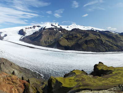 Skaftafellsjökull and Öræfajökull
 Panoramic afternoon view from a promontory of Kristínartindar in southeastern direction. Skaftafell...") Skaftafellsjökull and Öræfajökull
Skaftafellsjökull and Öræfajökull Panoramic afternoon view from Kristínartindar in southeastern direction. Skaftafellsjökull, domina...") Skaftafellsjökull and Öræfajökull
Skaftafellsjökull and Öræfajökull Afternoon view from Skaftafellsheiði in southeastern direction. Skaftafellsjökull, dominating the ...") Skaftafellsjökull and Öræfajökull
Skaftafellsjökull and Öræfajökull Panoramic afternoon view from Kristínartindar in northwestern direction") Morsárdalur
Morsárdalur Panoramic afternoon view from Kristínartindar in northwestern direction") Morsárdalur with Morsárjökull
Morsárdalur with Morsárjökull Sunset view from the Gígjukvísl Bridge Memorial in eastern direction to Svínafellsjökull, an out...") Öræfajökull | Svínafellsjökull and Hvannadalshnúkur
Öræfajökull | Svínafellsjökull and Hvannadalshnúkur Sunset view from the Gígjukvísl Bridge Memorial in eastern direction to Svínafellsjökull, an out...") Öræfajökull | Svínafellsjökull and Hvannadalshnúkur
Öræfajökull | Svínafellsjökull and Hvannadalshnúkur Evening view from the Gígjukvísl Bridge Memorial in eastern direction to Svínafellsjökull, an ou...") Öræfajökull | Svínafellsjökull and Hvannadalshnúkur
Öræfajökull | Svínafellsjökull and Hvannadalshnúkur Part of the tongue of Svínafellsjökull (in the foreground) is in a state of thinning and decay. Ev...") Svínafellsjökull and Skeiðarárjökull
Svínafellsjökull and Skeiðarárjökull Part of the tongue of Svínafellsjökull (in the foreground) is in a state of thinning and decay. Ev...") Svínafellsjökull and Skeiðarárjökull
Svínafellsjökull and Skeiðarárjökull This hole is part of a system of crevasses. A volume of several tens of millions of cubic metres is ...") Svínafellsheiði | Fracture
Svínafellsheiði | Fracture View from Svínafellsheiði in western direction. The mass of debris on the tongue of Svínafellsjö...") Svínafellsjökull and Skeiðarárjökull
Svínafellsjökull and Skeiðarárjökull View from Svínafellsheiði down to the terminus of Svínafellsjökull and one of its proglacial lak...") Svínafellsjökull | Terminus with proglacial lake
Svínafellsjökull | Terminus with proglacial lake The mass of debris on the glacier tongue represents the deposit of a landslide which occurred in 201...") Svínafellsjökull with landslide deposit
Svínafellsjökull with landslide deposit Part of the glacier tongue is in a state of thinning and decay. Even though the glacier did not expe...") Svínafellsjökull | Proglacial lake with icebergs
Svínafellsjökull | Proglacial lake with icebergs Part of the glacier tongue is in a state of thinning and decay. Even though the glacier did not expe...") Svínafellsjökull | Proglacial lake with icebergs
Svínafellsjökull | Proglacial lake with icebergs Part of the glacier tongue is in a state of thinning and decay. Even though the glacier did not expe...") Svínafellsjökull | Glacier terminus
Svínafellsjökull | Glacier terminus Svínafellsjökull represents an outlet glacier of the ice cap Vatnajökull. It flows down the slope...") Svínafellsjökull reflecting in proglacial lake
Svínafellsjökull reflecting in proglacial lake Another outlet glacier of Vatnajökull. It flows down the southwestern slope of the volcano Öræfaj...") Öræfajökull | Kotarjökull
Öræfajökull | Kotarjökull This outlet glacier of Vatnajökull flows down the southeastern slope of the volcano Öræfajökull.") Öræfajökull | Kvíárjökull panorama
Öræfajökull | Kvíárjökull panorama This outlet glacier of Vatnajökull flows down the southeastern slope of the volcano Öræfajökull.") Öræfajökull | Kvíárjökull
Öræfajökull | Kvíárjökull Outlet glacier of Vatnajökull, reflecting in a lake. Kvíárjökull flows down the southeastern slo...") Öræfajökull | Reflection of Kvíárjökull
Öræfajökull | Reflection of Kvíárjökull Morning view from a terminal moraine of Breiðamerkurjökull in western direction to the volcano Ör...") Öræfajökull with Hvannadalshnúkur
Öræfajökull with Hvannadalshnúkur Morning view from a terminal moraine of Breiðamerkurjökull in southwestern direction to the highes...") Öræfajökull with Hvannadalshnúkur
Öræfajökull with Hvannadalshnúkur Bridge crossing the outlet of Jökulsárlón, view in southwestern direction. The volcano Öræfajö...") Ring Road | Bridge with Öræfajökull
Ring Road | Bridge with Öræfajökull Panoramic view of Jökulsárlón with the volcano Öræfajökull (Hvannadalshnúkur, highest peak of...") Jökulsárlón with icebergs and Breiðamerkurjökull
Jökulsárlón with icebergs and Breiðamerkurjökull View of Jökulsárlón with Breiðamerkurjökull in the background. This outlet glacier of Vatnajök...") Jökulsárlón with icebergs and Breiðamerkurjökull
Jökulsárlón with icebergs and Breiðamerkurjökull Icebergs originating from Breiðamerkurjökull in the background. This outlet glacier of Vatnajökul...") Jökulsárlón with icebergs and Breiðamerkurjökull
Jökulsárlón with icebergs and Breiðamerkurjökull Icebergs originating from Breiðamerkurjökull in the background. This outlet glacier of Vatnajökul...") Jökulsárlón with icebergs and Breiðamerkurjökull
Jökulsárlón with icebergs and Breiðamerkurjökull Icebergs originating from Breiðamerkurjökull in the background. This outlet glacier of Vatnajökul...") Jökulsárlón with icebergs and Breiðamerkurjökull
Jökulsárlón with icebergs and Breiðamerkurjökull Icebergs originating from Breiðamerkurjökull in the background. This outlet glacier of Vatnajökul...") Jökulsárlón with icebergs and Breiðamerkurjökull
Jökulsárlón with icebergs and Breiðamerkurjökull View of Jökulsárlón with the volcano Öræfajökull (Hvannadalshnúkur, highest peak of Iceland, ...") Jökulsárlón with icebergs and Öræfajökull
Jökulsárlón with icebergs and Öræfajökull Breiðamerkurjökull appears in the background. This outlet glacier of Vatnajökull has experienced ...") Jökulsárlón and Breiðamerkurjökull
Jökulsárlón and Breiðamerkurjökull Morning view from the Ring Road near Reynivellir in southwestern direction to the volcano Öræfajö...") Öræfajökull with Hvannadalshnúkur
Öræfajökull with Hvannadalshnúkur This southeastern part of Iceland has been an extremely remote place between the devastating 1362 er...") Breiðabólsstaður and Öræfajökull
Breiðabólsstaður and Öræfajökull This southeastern part of Iceland has been an extremely remote place between the devastating 1362 er...") Breiðabólsstaður and Öræfajökull
Breiðabólsstaður and Öræfajökull Harbour of the largest urban place in southeastern Iceland. This part of the country has been an ext...") Höfn
Höfn Outlet glacier of the ice cap Vatnajökull, seen from Höfn") Hoffellsjökull
Hoffellsjökull View from Höfn in southwestern direction to the volcano Öræfajökull with Hvannadalshnúkur, the ...") Öræfajökull with Hvannadalshnúkur
Öræfajökull with Hvannadalshnúkur Panoramic view from the vicinity of the lighthouse of Hvalnes in western direction") Hvalnes | Lónsvík with the spit of Fjörur
Hvalnes | Lónsvík with the spit of Fjörur View from the Ring Road in northern direction") East coast with Mælifell
East coast with Mælifell View from the Ring Road in northern direction") East coast near Mælifell
East coast near Mælifell The small town of Djúpivogur is located on the headland between Hamarsfjörður and Berufjörður (...") Djúpivogur | Harbour
Djúpivogur | Harbour This small town is located on the headland between Hamarsfjörður (left background) and Berufjörð...") Djúpivogur | Panoramic view
Djúpivogur | Panoramic view This small town is located on the headland between Hamarsfjörður and Berufjörður (right backgrou...") Djúpivogur | Panoramic view with Berufjörður
Djúpivogur | Panoramic view with Berufjörður View from the Ring Road across Berufjörður. Fish farming is a common industry in the Eastfjords.") Berufjörður with fish farm
Berufjörður with fish farm Another fjord the Ring Road has to circumnavigate.") Stöðvarfjörður with Ring Road
Stöðvarfjörður with Ring Road View in western direction into Stöðvarfjörður. The village of the same name appears in the right...") Stöðvarfjörður
Stöðvarfjörður View from the Ring Road in northwestern direction. Fish farming is a common industry in the Eastfjor...") Fáskrúðsfjörður with fish farm
Fáskrúðsfjörður with fish farm View from the Ring Road in northwestern direction") Fáskrúðsfjörður
Fáskrúðsfjörður View from the Ring Road in northwestern direction. Fish farming is a common industry in the Eastfjor...") Fáskrúðsfjörður with fish farm
Fáskrúðsfjörður with fish farm View from Námafjall down to the geothermal field of Hverir. The Mid Atlantic Ridge runs through the...") Mývatn | Hverir
Mývatn | Hverir View from a mountainside near the ranger station of Dreki in northeastern direction. The bright surf...") Dreki | Highland with Herðubreið
Dreki | Highland with Herðubreið View from a mountainside near the ranger station of Dreki in northeastern direction. The bright surf...") Dreki | Highland panorama
Dreki | Highland panorama Summit elevation of this shield volcano: 1177 m") Kollóttadyngja
Kollóttadyngja View from a mountainside near the ranger station of Dreki in northern direction. The bright surface ...") Dreki | Highland with Kollóttadyngja and lava field
Dreki | Highland with Kollóttadyngja and lava field Askja represents a volcanic system with nested calderas north of Vatnajökull. A major eruption in 1...") Askja Caldera | Víti and Öskjuvatn
Askja Caldera | Víti and Öskjuvatn Askja represents a volcanic system with nested calderas north of Vatnajökull. A major eruption in 1...") Askja Caldera | Víti and Öskjuvatn
Askja Caldera | Víti and Öskjuvatn Askja represents a volcanic system with nested calderas north of Vatnajökull. A major eruption in 1...") Askja Caldera | Öskjuvatn
Askja Caldera | Öskjuvatn Askja represents a volcanic system with nested calderas north of Vatnajökull. The eruption of 1875 ...") Askja Caldera | Öskjuvatn and landslide
Askja Caldera | Öskjuvatn and landslide These mounds most likely represent part of an ancient landslide deposit.") Hnausar | Ancient landslide
Hnausar | Ancient landslide View to the northwestern coast of Ísafjarðardjúp. Its name Snæfjallaströnd is related to the fa...") Ísafjarðardjúp with Snæfjallaströnd
Ísafjarðardjúp with Snæfjallaströnd View across Ísafjarðardjúp to the bay of Kaldalón and the northernmost ice cap of Iceland, culmi...") Ísafjarðardjúp with Drangajökull
Ísafjarðardjúp with Drangajökull Late afternoon view of the town centre of Ísafjörður, reflecting in the calm backwater protected ...") Ísafjörður | Reflections
Ísafjörður | Reflections Late afternoon view of the town centre of Ísafjörður, reflecting in the calm backwater protected ...") Ísafjörður | Panoramic reflections
Ísafjörður | Panoramic reflections Snow avalanches are sometimes a major issue here. Technical measures have been implemented in order ...") Ísafjörður | Avalanche protection
Ísafjörður | Avalanche protection Late afternoon view in southeastern direction. The largest settlement of the Westfjords has been bui...") Ísafjörður with Skutulsfjörður
Ísafjörður with Skutulsfjörður Late afternoon view in southeastern direction. The largest settlement of the Westfjords has been bui...") Skutulsfjörður panorama with Ísafjörður
Skutulsfjörður panorama with Ísafjörður Late afternoon view in northern direction. The largest settlement of the Westfjords has been built o...") Skutulsfjörður panorama with Ísafjörður
Skutulsfjörður panorama with Ísafjörður View from the summit area of Óshyrna down to the small town of Bolungarvík, going back to one of I...") Bolungarvík
Bolungarvík View from Road 61, ascending to Tröllatunguheiði, in southwestern direction") Geirdalsá Valley and Breiðafjörður
Geirdalsá Valley and Breiðafjörður This type of cultural landscape and livestock is commonly encountered along the coast of Iceland.") Hvolsá Valley | Cultural landscape
Hvolsá Valley | Cultural landscape Panoramic view from Grettisbæli. This extremely mobile rock avalanche occurred in the morning of 7 ...") Hítardalur with Fagraskógarfjall-Hítardalur Landslide
Hítardalur with Fagraskógarfjall-Hítardalur Landslide View from Grettisbæli. This extremely mobile rock avalanche occurred in the morning of 7 July 2018....") Hítardalur with Fagraskógarfjall-Hítardalur Landslide
Hítardalur with Fagraskógarfjall-Hítardalur Landslide This extremely mobile rock avalanche occurred in the morning of 7 July 2018. It travelled over a dis...") Fagraskógarfjall-Hítardalur Landslide | Panoramic view
Fagraskógarfjall-Hítardalur Landslide | Panoramic view This extremely mobile rock avalanche occurred in the morning of 7 July 2018. It travelled over a dis...") Fagraskógarfjall-Hítardalur Landslide | Panoramic view
Fagraskógarfjall-Hítardalur Landslide | Panoramic view This extremely mobile rock avalanche occurred in the morning of 7 July 2018. It travelled over a dis...") Fagraskógarfjall-Hítardalur Landslide | Panoramic view
Fagraskógarfjall-Hítardalur Landslide | Panoramic view View from the Hotel Kazzhol in southeastern direction. The 372 m high Almaty Tower built on the slop...") Almaty with Zailiysky Alatau Range
Almaty with Zailiysky Alatau Range View from the Hotel Kazzhol in southeastern direction to the 372 m high TV tower on the slopes of th...") Almaty Tower with Zailiysky Alatau Range
Almaty Tower with Zailiysky Alatau Range The road B3 (section Narok - Mai Mahiu) is seen in the foreground whilst the shield volcano Mount Su...") East African Rift Valley with Mt. Suswa
East African Rift Valley with Mt. Suswa View from the road B5 between Nyeri and Nyahururu to the Aberdare Range (culminating at 3999 m asl)") White Highlands with Aberdare Range
White Highlands with Aberdare Range View from the road B5 between Nyeri and Nyahururu to the Aberdare Range (culminating at 3999 m asl)") White Highlands with Aberdares
White Highlands with Aberdares View from the road B6 (section Subuiga - Meru) to two volcanic cones on the northern slopes of Mt. K...") Mount Kenya Ring Road
Mount Kenya Ring Road Teleki Valley at approx. 4000 m asl. The giant inflorescence in the centre belongs to Lobelia teleki...") Mount Kenya NP | Afroalpine vegetation
Mount Kenya NP | Afroalpine vegetation Teleki Valley, elevation: approx. 4300 m asl. The giant inflorescence in the centre of the image bel...") Mount Kenya NP | Afroalpine vegetation
Mount Kenya NP | Afroalpine vegetation Slopes of Pt. Lenana towards the Gorges Valley, elevation: approx. 4500 m. The giant inflorescence i...") Mount Kenya NP | Lobelia telekii
Mount Kenya NP | Lobelia telekii Teleki Valley, elevation: approx. 4000 m asl. The giant groundsels with stems represent the species ...") Mount Kenya NP | Afroalpine vegetation
Mount Kenya NP | Afroalpine vegetation Summit area of Mt. Kenya: view from Pt. Lenana (4985 m) to Nelion (5188 m). The Lewis Glacier appear...") Mount Kenya NP | Nelion
Mount Kenya NP | Nelion Early morning view from Pt. Lenana (4985 m) towards northeast") Mount Kenya NP | View from Pt. Lenana
Mount Kenya NP | View from Pt. Lenana Early morning view from Pt. Lenana (4985 m) towards south to the Hobley Valley (left centre) and the...") Mount Kenya NP | Hobley Valley
Mount Kenya NP | Hobley Valley Early morning view from Pt. Lenana (4985 m) towards northeast. The Gorges Valley appears in the righ...") Mount Kenya NP | View from Pt. Lenana
Mount Kenya NP | View from Pt. Lenana Early morning view from Pt. Lenana (4985 m) towards east down to the Gorges Valley. The Hall Tarns a...") Mount Kenya NP | Gorges Valley
Mount Kenya NP | Gorges Valley Glacially shaped landscape with tussock grassland, elevation: approx. 4100 m asl. Lake Michaelson ap...") Mount Kenya NP | Gorges Valley with Lake Michaelson
Mount Kenya NP | Gorges Valley with Lake Michaelson Glacially shaped landscape in the Gorges Valley, elevation: approx. 4000 m asl. The giant groundsel ...") Mount Kenya NP | Senecio battiscombei
Mount Kenya NP | Senecio battiscombei The heathlands occupying the eastern slopes of Mt. Kenya at approx. 3300 m asl display a certain res...") Mount Kenya NP | Burnt heathland
Mount Kenya NP | Burnt heathland The heathlands occupying the eastern slopes of Mt. Kenya at approx. 3300 m asl display a certain res...") Mount Kenya NP | Burnt heathland
Mount Kenya NP | Burnt heathland The heathlands occupying the eastern slopes of Mt. Kenya at approx. 3300 m asl display a certain res...") Mount Kenya NP | Burnt heathland
Mount Kenya NP | Burnt heathland View from the 6th floor of the Hyatt Regency Hotel towards S") Bishkek and Ala-Too Range
Bishkek and Ala-Too Range View towards W") Ala-Too Range
Ala-Too Range View towards W") Toktogul Reservoir
Toktogul Reservoir Location: near Karamyk, view towards E. The Trans Alai Range with Ibn Sina Peak (7134 m) is seen in ...") Chan-Alai Valley
Chan-Alai Valley Location: near Karamyk, view towards NE") Chan-Alai Valley
Chan-Alai Valley Location: S of Shibez, view towards SW") Trans Alai Range
Trans Alai Range View towards NE to the Chan-Alai Valley in the background") Trans Alai Range with Chan-Alai Valley
Trans Alai Range with Chan-Alai Valley View in northeastern direction across the entire island of Antigua. The volcanic southwestern part w...") Antigua at once
Antigua at once View in southeastern direction. Mt. Obama (402 m) appears in the right central background of the pic...") Jolly Harbour with Mt. Obama
Jolly Harbour with Mt. Obama View in southeastern direction. Mt. Obama (402 m) appears in the right central background of the pic...") Jolly Harbour with Mt. Obama
Jolly Harbour with Mt. Obama View in southeastern direction. The beach of Mosquito Cove appears in the centre of the photo, Jolly...") Mosquito Cove and Jolly Harbour
Mosquito Cove and Jolly Harbour View across Jolly Harbour and along Jolly Beach and Valley Church Beach in southern direction. Mt. O...") Jolly Harbour
Jolly Harbour View in southern direction to Mt. Obama (402 m) in the central background") Bolands with Mt. Obama
Bolands with Mt. Obama View north. The southern part of Montserrat was permanently evacuated after the reactivation of the ...") Belham River Valley and Centre Hills
Belham River Valley and Centre Hills View north. The southern part of Montserrat was permanently evacuated after the reactivation of the ...") Belham River Valley and Centre Hills
Belham River Valley and Centre Hills View in northwestern direction, Centre Hills in the background. The reactivation of the Soufrière H...") Bethel | Volcanic deposits
Bethel | Volcanic deposits View in northwestern direction, Centre Hills in the background. The reactivation of the Soufrière H...") Bethel | Volcanic deposits
Bethel | Volcanic deposits View in northwestern direction, Centre Hills in the background. The reactivation of the Soufrière H...") Bethel | Volcanic deposits
Bethel | Volcanic deposits View from Sweeney's Main Road in southern direction. This northern part of the island was sparsely i...") Centre Hills
Centre Hills Panoramic view from the trail to the Boiling Lake (ascent to Morne Nicholls) in northeastern directi...") Morne Trois Pitons NP
Morne Trois Pitons NP Panoramic view from Morne Nicholls in northeastern direction. The mountain rainforest has been damag...") Morne Trois Pitons NP
Morne Trois Pitons NP Panoramic view from the trail to the Boiling Lake, descending from Morne Nicholls to the Valley of D...") Morne Trois Pitons NP with Valley of Desolation
Morne Trois Pitons NP with Valley of Desolation View from the trail to the Boiling Lake, descending from Morne Nicholls to the Valley of Desolation") Morne Trois Pitons NP | Valley of Desolation
Morne Trois Pitons NP | Valley of Desolation Panoramic view southwest to Morne Nicholls. The Valley of Desolation is a geothermally active area w...") Morne Trois Pitons NP | Valley of Desolation
Morne Trois Pitons NP | Valley of Desolation View from the trail to the Boiling Lake. The Valley of Desolation is a geothermally active area, whi...") Morne Trois Pitons NP | Valley of Desolation
Morne Trois Pitons NP | Valley of Desolation View from the final section of the trail to the Boiling Lake in southwestern direction. This area is...") Morne Trois Pitons NP with geothermal fields
Morne Trois Pitons NP with geothermal fields View from the ferry connecting Dominica and Martinique in northern direction to the southernmost par...") Southern Dominica
Southern Dominica View from Morne Vert Pré. This cliff exposes mainly pyroclastic deposits at the western slope of Mo...") Le Prêcheur | Falaise Samperre
Le Prêcheur | Falaise Samperre View from Morne Vert Pré. This cliff exposes mainly pyroclastic deposits at the western slope of Mo...") Le Prêcheur | Falaise Samperre
Le Prêcheur | Falaise Samperre This torrent drains the western slope of Montagne Pelée. It is susceptible to lahar flows involving...") Le Prêcheur | Rivière du Prêcheur
Le Prêcheur | Rivière du Prêcheur This torrent drains the western slope of Montagne Pelée. It is susceptible to lahar flows involving...") Le Prêcheur | Rivière du Prêcheur at sunset
Le Prêcheur | Rivière du Prêcheur at sunset View from the slopes of Montagne Pelée in southern direction") Pitons du Carbet and Saint-Pierre
Pitons du Carbet and Saint-Pierre Western slopes of the cones which formed in 1902 (left) and 1929-1932 (right). The western summit (1...") Montagne Pelée | Summit cone
Montagne Pelée | Summit cone Eastern slopes of L'Aileron (1107 m), a promontory of Montagne Pelée. The treeline is formed by tre...") Montagne Pelée | Tree ferns and L'Aileron
Montagne Pelée | Tree ferns and L'Aileron Eastern slopes of L'Aileron (1107 m), a promontory of Montagne Pelée. The treeline is formed by tre...") Montagne Pelée | Tree fern and L'Aileron
Montagne Pelée | Tree fern and L'Aileron View from the slope of the 1902 lava dome in northeastern direction. The summit of Morne Lacroix (12...") Montagne Pelée | Morne Lacroix
Montagne Pelée | Morne Lacroix Panoramic view from the slope of the 1902 lava dome in northeastern direction. The summit of Morne L...") Montagne Pelée | Caldera rim with Morne Lacroix
Montagne Pelée | Caldera rim with Morne Lacroix View from the Grande Anse des Salines over a distance of 20 km to the southwestern part of Martiniqu...") Rocher du Diamant and Morne Larcher
Rocher du Diamant and Morne Larcher View from the road Tahannaout - Moulay Brahim across Oued Rheraya") Tahannaout | Riverine forest
Tahannaout | Riverine forest View from the road Tahannaout - Moulay Brahim") Tahannaout | Oued Rheraya
Tahannaout | Oued Rheraya View from the bed of Oued Rheraya downstream - elevation: approx. 1900 m asl.") Aït Mizane Valley with Aroumd
Aït Mizane Valley with Aroumd View upstream - elevation: approx. 1900 m asl.") Aït Mizane Valley | Aroumd
Aït Mizane Valley | Aroumd Prunus persica, location: near Aroumd") Aït Mizane Valley | Flowering peach tree
Aït Mizane Valley | Flowering peach tree Elevation: approx. 2300 m asl. A small juniper tree (Juniperus thurifera) is seen in the background.") Aït Mizane Valley | Thorn shrub vegetation
Aït Mizane Valley | Thorn shrub vegetation Elevation: approx. 2300 m asl.") Aït Mizane Valley | Thorn shrub vegetation
Aït Mizane Valley | Thorn shrub vegetation Elevation: 2260 m asl.") Tizi n'Tichka | Souvenirs
Tizi n'Tichka | Souvenirs This fortified village (ighrem or ksar) was established along the former caravan route between Marra...") Aït Benhaddou with High Atlas
Aït Benhaddou with High Atlas This fortified village (ighrem or ksar) was established along the former caravan route between Marra...") Aït Benhaddou with High Atlas
Aït Benhaddou with High Atlas This fortified village (ighrem or ksar) was established along the former caravan route between Marra...") Aït Benhaddou with High Atlas
Aït Benhaddou with High Atlas Viewpoint near Aït Benhaddou") Oued El Malleh and High Atlas
Oued El Malleh and High Atlas View from Kchait towards northwest") Ouarzazate | Oasis and High Atlas
Ouarzazate | Oasis and High Atlas View from Kchait towards northeast") Ouarzazate | Desert and High Atlas
Ouarzazate | Desert and High Atlas View from Ouarzazate across the oasis of the Asif Tidili River") Anti-Atlas
Anti-Atlas The area of Tinghir includes various villages along an oasis extending for 30 km along the Wadi Togd...") Tinghir | Wadi Todgha
Tinghir | Wadi Todgha Phoenix dactylifera. The area of Tinghir includes various villages along an oasis extending for 30 k...") Tinghir | Date palm
Tinghir | Date palm The area of Tinghir includes various villages along an oasis extending for 30 km along the Wadi Todg...") Tinghir | Wadi Todgha
Tinghir | Wadi Todgha This narrow gorge cuts through the southeastern rim of the High Atlas, directly before the valley of...") Todgha Gorge
Todgha Gorge This narrow gorge cuts through the southeastern rim of the High Atlas, directly before the valley of...") Todgha Gorge
Todgha Gorge The Todgha Gorge cuts through the southeastern rim of the High Atlas, directly before the valley of ...") Todgha Gorge | Folded rocks
Todgha Gorge | Folded rocks This narrow gorge cuts through the southeastern rim of the High Atlas, directly before the valley of...") Todgha Gorge
Todgha Gorge This narrow gorge cuts through the southeastern rim of the High Atlas, directly before the valley of...") Todgha Gorge
Todgha Gorge Phoenix dactylifera. The Todgha Gorge cuts through the southeastern rim of the High Atlas, directly ...") Todgha Gorge | Date palm
Todgha Gorge | Date palm Phoenix dactylifera. This narrow gorge cuts through the southeastern rim of the High Atlas, directly...") Todgha Gorge with date palm
Todgha Gorge with date palm (4402 visits) Flight Cape Town - Frankfurt") Hoggar Mountains (Algeria)
Hoggar Mountains (Algeria) Ziz River cutting through the southern rim of the High Atlas, view downstream") Errachidia | Gorges du Ziz
Errachidia | Gorges du Ziz Gorge of the Ziz River cutting through the southern rim of the High Atlas, view upstream") Errachidia | Gorges du Ziz
Errachidia | Gorges du Ziz Thistle-like plant. The gorge of the Ziz River cutting through the southern rim of the High Atlas ap...") Errachidia | Gorges du Ziz
Errachidia | Gorges du Ziz A piece of gravel desert (serir) is shown in the foreground. Note the sharp boundary between bedrock...") Er-Rich | Serir
Er-Rich | Serir View towards a snow-covered range of the High Atlas") Er-Rich | Road N13
Er-Rich | Road N13 This mountain pass of the road N13 crosses one of the ranges of the High Atlas, connecting Midelt an...") Col Talghomt
Col Talghomt Panoramic view from the road between Midelt and Col Talghomt") Moulouya Basin
Moulouya Basin") Col du Zad | Lagoon
Col du Zad | Lagoon Juniperus thurifera and Cedrus atlantica") Col du Zad | Juniper and cedar forest
Col du Zad | Juniper and cedar forest Location: near Douar Nzala and Lac de Sidi Chahede") Zerhoun Mountains
Zerhoun Mountains Location: near Douar Nzala and Lac de Sidi Chahede") Zerhoun Mountains
Zerhoun Mountains View from Pico dos Barcelos in NE direction up the slopes of the Central Mountain Massif. The suburb...") Funchal | Suburban areas
Funchal | Suburban areas View from Pico dos Barcelos in NE direction up the slopes of the Central Mountain Massif. The suburb...") Funchal | Suburban areas at sunset
Funchal | Suburban areas at sunset View from Pico da Torre in N direction up the slopes of the Central Mountain Massif. The intensively...") Câmara de Lobos | Cultural landscape
Câmara de Lobos | Cultural landscape This bridge near Câmara de Lobos is more than 100 m high. Completed in the mid 1990s, it carries th...") Ponte dos Socorridos
Ponte dos Socorridos This bridge near Câmara de Lobos is more than 100 m high. Completed in the mid 1990s, it carries th...") Ribeira dos Socorridos with Ponte dos Socorridos
Ribeira dos Socorridos with Ponte dos Socorridos This bridge near Câmara de Lobos is more than 100 m high. Completed in the mid 1990s, it carries th...") Ribeira dos Socorridos with Ponte dos Socorridos
Ribeira dos Socorridos with Ponte dos Socorridos Panoramic late afternoon view from Estrada 1 de Julho (slopes of Cabo Girão) in E direction to the ...") Suburbs of Funchal with Câmara de Lobos
Suburbs of Funchal with Câmara de Lobos View in E direction. The village of Seixal extends on the slopes of a small basaltic headland along ...") Seixal with vineyard and cliff coast
Seixal with vineyard and cliff coast View in SE direction. The village of Seixal extends on the slopes of a small basaltic headland along...") Seixal | Farmland and cliff coast
Seixal | Farmland and cliff coast