

 Planted forest of Araucaria angustifolia in the background") Misiones | Timber transport
Misiones | Timber transport Location: near National Road 12") Misiones | Banana cultivation
Misiones | Banana cultivation This photo shows an area with exposed tropical red soil rich in iron and aluminium oxides.") Misiones | Soil erosion
Misiones | Soil erosion Lianas - using the stems and branches of other trees to reach the sunlight - are commonly encountere...") PN Iguazú | Liana
PN Iguazú | Liana The Iguazú Falls represent the largest system of waterfalls in the World. The Iguazú River - formi...") PN Iguazú | Cataratas de Iguazú
PN Iguazú | Cataratas de Iguazú The Iguazú Falls represent the largest system of waterfalls in the World. The Iguazú River plunges...") PN Iguazú | Cataratas de Iguazú
PN Iguazú | Cataratas de Iguazú View from Isla San Martín. The Iguazú Falls represent the largest system of waterfalls in the Worl...") PN Iguazú | Salto San Martín
PN Iguazú | Salto San Martín View from Isla San Martín. The Iguazú Falls represent the largest system of waterfalls in the Worl...") PN Iguazú | Salto Mbiguá
PN Iguazú | Salto Mbiguá (4968 visits) The Iguazú Falls represent the largest system of waterfalls in the World. The Iguazú River - formi...") PN Iguaçu | Salto Floriano (Brazil)
PN Iguaçu | Salto Floriano (Brazil) View from Brazil. The Iguazú Falls represent the largest system of waterfalls in the World. The Igu...") PN Iguazú | Garganta del Diablo
PN Iguazú | Garganta del Diablo View from Isla San Martín. The Iguazú Falls represent the largest system of waterfalls in the Worl...") PN Iguazú | Salto Bernabé Méndez
PN Iguazú | Salto Bernabé Méndez View from Isla San Martín. The Iguazú Falls represent the largest system of waterfalls in the Worl...") PN Iguazú | Salto San Martín
PN Iguazú | Salto San Martín (6618 visits) The Iguazú Falls represent the largest system of waterfalls in the World. The Iguazú River - formi...") PN Iguaçu | Salto Santa Maria (Brazil)
PN Iguaçu | Salto Santa Maria (Brazil) (6499 visits) The Iguazú Falls represent the largest system of waterfalls in the World. The Iguazú River - formi...") PN Iguaçu | Salto Santa Maria (Brazil)
PN Iguaçu | Salto Santa Maria (Brazil) View from Brazil. The Iguazú Falls represent the largest system of waterfalls in the World. The Igu...") PN Iguazú | Salto Tres Mosqueteros and Salto Rivadavia
PN Iguazú | Salto Tres Mosqueteros and Salto Rivadavia The Iguazú Falls represent the largest system of waterfalls in the World. The Iguazú River - formi...") PN Iguazú | Salto Dos Hermanas
PN Iguazú | Salto Dos Hermanas (4035 visits) View from the Puente de la Amistad in S direction. Foz do Iguaçu can be seen in the background of t...") Río Paraná (Paraguay | Brazil)
Río Paraná (Paraguay | Brazil) (4088 visits) View from Paraguay near the Itaipú Dam. Foz do Iguaçu appears in the left, Ciudad del Este in the ...") Río Paraná (Paraguay | Brazil)
Río Paraná (Paraguay | Brazil)") San Agustín | Río Magdalena
San Agustín | Río Magdalena Cloud forest with tree ferns, view from the Isnos - Ullucos road") Isnos | Tree fern
Isnos | Tree fern Cloud forest with tree ferns Cyathaea sp., view from the Isnos - Ullucos road") Isnos | Cloud forest
Isnos | Cloud forest The black colour of the river (poorly visible) indicates that it originates on the páramo, view fro...") Puracé NP | Creek
Puracé NP | Creek (4612 visits) Momotus momota, view from the road Isnos - Ullucos") PN Puracé | Blue-crowned motmot (soledad)
PN Puracé | Blue-crowned motmot (soledad) Reserva Natural El Laurel") Cuenca Río Piedras | Tucan
Cuenca Río Piedras | Tucan Piedra del Condor, the meat was placed there to attract the condor") Puracé NP | Piedra del Condor
Puracé NP | Piedra del Condor") Puracé NP | Piedra del Condor
Puracé NP | Piedra del Condor Páramo with frailejones near the road from Puracé to San Juan") Puracé NP | Espeletia sp.
Puracé NP | Espeletia sp.") Termales San Juan | Cycad tree
Termales San Juan | Cycad tree Area affected by post-volcanic processes") Termales San Juan | Cycas sp.
Termales San Juan | Cycas sp.") Termales San Juan | Sulphur springs
Termales San Juan | Sulphur springs") Termales San Juan | Puya sp.
Termales San Juan | Puya sp. Lupine on the slopes of Volcán Puracé") Puracé NP | Lupinus sp.
Puracé NP | Lupinus sp. Lupine on the slopes of Volcán Puracé") Puracé NP | Lupinus sp.
Puracé NP | Lupinus sp.") Puracé NP | Páramo
Puracé NP | Páramo") Puracé NP | Páramo drainage
Puracé NP | Páramo drainage") Puracé | Sunset near Pilimbala
Puracé | Sunset near Pilimbala") Puracé | Sunset near Pilimbala
Puracé | Sunset near Pilimbala") Puracé | Sunset near Pilimbala
Puracé | Sunset near Pilimbala View from Popayan - Puracé road") Coconuco | Landslide
Coconuco | Landslide View from Popayán - Puracé road") Cauca Valley near Coconuco
Cauca Valley near Coconuco") Cuenca Río Piedras | Reserva Natural El Laurel
Cuenca Río Piedras | Reserva Natural El Laurel This reservoir on the Cauca River belongs tho the Hidroituango hydropower plant, projected for vario...") Cauca Valley | Hidroituango Reservoir and Dam
Cauca Valley | Hidroituango Reservoir and Dam This 225 m high embankment dam on the Cauca River is part of a hydropower project under construction...") Cauca Valley | Hidroituango Dam and Reservoir
Cauca Valley | Hidroituango Dam and Reservoir This 225 m high embankment dam on the Cauca River is part of a hydropower project under construction...") Cauca Valley | Hidroituango Dam and Reservoir
Cauca Valley | Hidroituango Dam and Reservoir This 225 m high embankment dam on the Cauca River is part of a hydropower project under construction...") Cauca Valley | Hidroituango Dam and Reservoir
Cauca Valley | Hidroituango Dam and Reservoir This spillway belongs to the 225 m high Hidroituango Dam on the Cauca River. Operation of the hydrop...") Cauca Valley | Spillway of Hidroituango Dam
Cauca Valley | Spillway of Hidroituango Dam The spillway at the bottom of this view belongs to the 225 m high Hidroituango Dam on the Cauca Rive...") Cauca Valley | Spillway of Hidroituango Dam
Cauca Valley | Spillway of Hidroituango Dam This 225 m high embankment dam on the Cauca River is part of a hydropower project under construction...") Cauca Valley | Hidroituango Dam with spillway
Cauca Valley | Hidroituango Dam with spillway This deep-seated landslide is located directly adjacent to the Hidroituango Reservoir, impounded by ...") Cauca Valley | Hidroituango Reservoir with landslide
Cauca Valley | Hidroituango Reservoir with landslide This deep-seated landslide is located directly adjacent to the Hidroituango Reservoir with its 225 m...") Cauca Valley | Landslide with Hidroituango Reservoir
Cauca Valley | Landslide with Hidroituango Reservoir One of various landslides affecting the the road from Medellín to the construction site of the Hidr...") San Andrés Valley | Landslide
San Andrés Valley | Landslide One of various landslides affecting the the road from Medellín to the construction site of the Hidr...") San Andrés Valley | Landslide
San Andrés Valley | Landslide Non-adapted land use, such as overgrazing, may result in weakening of the structure of the soil, wit...") Northern highlands of Antioquia | Soil erosion
Northern highlands of Antioquia | Soil erosion NW escarpment of the N highlands of Antioquia. A mix of cultural landscape and mountain rainforest c...") San Andrés Valley | Mountain landscape
San Andrés Valley | Mountain landscape View from the vicinity of the restaurant El Mico up the Río San Andrés in SW direction. The N high...") Northern highlands of Antioquia with Río San Andrés
Northern highlands of Antioquia with Río San Andrés View from the vicinity of the restaurant El Mico in SE direction. The N highlands of Antioquia, here...") Northern highlands of Antioquia with grazing grounds
Northern highlands of Antioquia with grazing grounds The N highlands of Antioquia are mainly used for large-scale cattle grazing. This type of covered wa...") Northern highlands of Antioquia | Cattle walkway
Northern highlands of Antioquia | Cattle walkway View from the mountain pass Alto de Matasanos across the Aburrá Valley in S direction to the E high...") Eastern highlands of Antioquia
Eastern highlands of Antioquia View from the Metrocable station Andalucía in NW direction down to the Río Medellín and to Bello,...") Aburrá Valley with Bello
Aburrá Valley with Bello View from the Metrocable station Andalucía in N direction down to the Río Medellín and to Bello, ...") Aburrá Valley with Bello
Aburrá Valley with Bello View from Santo Domingo in SW direction up the Aburrá Valley. The downtown of Medellín (La Candela...") Aburrá Valley with Medellín and Sabaneta
Aburrá Valley with Medellín and Sabaneta View from the Metro station Prado in W direction") Medellín | Calle 58
Medellín | Calle 58 This landslide near San Antonio de Prado happened on 13 July 2022, resulting in two fatalities. Deep...") Quebrada Doña María with landslide
Quebrada Doña María with landslide This landslide near San Antonio de Prado happened on 13 July 2022, resulting in two fatalities. Deep...") Quebrada Doña María | Landslide
Quebrada Doña María | Landslide Flight Lima Medellín, view in E direction. The E highlands of Antioquia, here at approx. 2100-2200 ...") La Ceja | Floriculture
La Ceja | Floriculture Flight Lima - Medellín, view over the E highlands of Antioquia in E direction. The foreground of th...") La Ceja | Vicinity of Cerro Chapecoense
La Ceja | Vicinity of Cerro Chapecoense View from Piedra del Peñól in SW direction. This hydropower reservoir with a water level of approx...") Eastern highlands of Antioquia with Embalse Peñol-Guatapé
Eastern highlands of Antioquia with Embalse Peñol-Guatapé Panoramic view from Piedra del Peñól in W direction. This hydropower reservoir with a water level ...") Eastern highlands of Antioquia with Embalse Peñol-Guatapé
Eastern highlands of Antioquia with Embalse Peñol-Guatapé View from Piedra del Peñól in NW direction. This hydropower reservoir with a water level of approx...") Eastern highlands of Antioquia with Embalse Peñol-Guatapé
Eastern highlands of Antioquia with Embalse Peñol-Guatapé View from Piedra del Peñól in N direction. This hydropower reservoir with a water level of approx....") Eastern highlands of Antioquia with Embalse Peñol-Guatapé
Eastern highlands of Antioquia with Embalse Peñol-Guatapé View from Piedra del Peñól in N direction. This hydropower reservoir with a water level of approx....") Eastern highlands of Antioquia with Embalse Peñol-Guatapé
Eastern highlands of Antioquia with Embalse Peñol-Guatapé Panoramic view from Piedra del Peñól in NW direction. This hydropower reservoir with a water level...") Eastern highlands of Antioquia with Embalse Peñol-Guatapé
Eastern highlands of Antioquia with Embalse Peñol-Guatapé Panoramic view from Piedra del Peñól in NE direction. This hydropower reservoir with a water level...") Eastern highlands of Antioquia with Embalse Peñol-Guatapé
Eastern highlands of Antioquia with Embalse Peñol-Guatapé View from Piedra del Peñól in NE direction to the small town of Guatapé. Filling of the hydropowe...") Eastern highlands of Antioquia with Guatapé
Eastern highlands of Antioquia with Guatapé Flight Lima - Medellín, view in E direction") Sonsón | Cordillera Central with Río Aures
Sonsón | Cordillera Central with Río Aures Flight Lima - Medellín, view in E direction") Sonsón | Cordillera Central with Río Arma
Sonsón | Cordillera Central with Río Arma Flight Lima - Medellín, view in E direction") Río Guayas with Rionegro
Río Guayas with Rionegro Location: near Liana Lodge and AmaZOOnico") Tena | Río Arajuno
Tena | Río Arajuno Location: near Liana Lodge and AmaZOOnico") Tena | Río Arajuno
Tena | Río Arajuno Location: near Liana Lodge and AmaZOOnico") Tena | Banana cultivation
Tena | Banana cultivation Theobroma cacao, location: near Liana Lodge and AmaZOOnico") Tena | Cacao
Tena | Cacao Theobroma cacao, location: near Liana Lodge and AmaZOOnico") Tena | Cacao fruit
Tena | Cacao fruit Ceiba sp., location: near Liana Lodge and AmaZOOnico") Tena | Buttress
Tena | Buttress Ceiba sp., location: near Liana Lodge and AmaZOOnico") Tena | Buttress
Tena | Buttress Ceiba sp., location: near Liana Lodge and AmaZOOnico") Tena | Buttress
Tena | Buttress Location: near Liana Lodge and AmaZOOnico") Tena | Tropical rainforest
Tena | Tropical rainforest") Tropical soil profile
Tropical soil profile Location: Baeza") Valle del Río Papallacta | Epiphytic bromeliad
Valle del Río Papallacta | Epiphytic bromeliad Location: Baeza") Valle del Río Papallacta | Remnant of cloud forest
Valle del Río Papallacta | Remnant of cloud forest") Valle del Río Papallacta | Cloud forest
Valle del Río Papallacta | Cloud forest Polylepis sp.") Paso de Papallacta | Polylepis
Paso de Papallacta | Polylepis Stem of Polylepis sp.") Paso de Papallacta | Polylepis
Paso de Papallacta | Polylepis Patches of Polylepis sp. forest alternate with the tussock grassland of the páramo.") Paso de Papallacta | Forest patches
Paso de Papallacta | Forest patches Some patches of Polylepis sp. forest are seen in the background.") Paso de Papallacta | Tussock grassland
Paso de Papallacta | Tussock grassland Giant rosette plants such as Espeletia hartwegiana are characteristic for the humid high-mountain ec...") Páramo El Ángel with frailejones
Páramo El Ángel with frailejones Giant rosette plants such as Espeletia hartwegiana are characteristic for the humid high-mountain ec...") Páramo El Ángel with frailejones
Páramo El Ángel with frailejones Giant rosette plants such as Espeletia hartwegiana are characteristic for the humid high-mountain ec...") Páramo El Ángel with frailejones
Páramo El Ángel with frailejones Giant rosette plants such as Espeletia hartwegiana are characteristic for the humid high-mountain ec...") Páramo El Ángel with frailejones
Páramo El Ángel with frailejones Giant rosette plants such as Espeletia hartwegiana are characteristic for the humid high-mountain ec...") Páramo El Ángel | Inflorescence of frailejón
Páramo El Ángel | Inflorescence of frailejón Puya clava-herculis. Comparable growth forms have developed in the mountains of tropical Africa (e.g...") Páramo El Ángel with puya
Páramo El Ángel with puya Puya clava-herculis. Comparable growth forms have developed in the mountains of tropical Africa (e.g...") Páramo El Ángel | Inflorescence of puya
Páramo El Ángel | Inflorescence of puya View from Highway E35 towards N") Valle del Río Chota
Valle del Río Chota The inactive Volcán Imbabura (4630 m) is seen in the left part of the image, Otavalo in the right c...") Otavalo and Volcán Imbabura
Otavalo and Volcán Imbabura View from Highway 35 near the town of Cayambe to the 5790 m high volcano") Volcán Cayambe
Volcán Cayambe Late afternoon view from Cruz Loma towards NE, Volcán Cayambe (5790 m) in the central background") Quito and Volcán Cayambe
Quito and Volcán Cayambe Late afternoon view from Cruz Loma to the 5704 m high stratovolcano") Volcán Antisana
Volcán Antisana View from Cruz Loma towards S-SW. The Eastern Cordillera (Volcán Cotopaxi hidden in clouds) is seen...") Quito | Panorama
Quito | Panorama Summit elevation: 5897 m") Volcán Cotopaxi
Volcán Cotopaxi View from Highway 30") Valle del Río Pastaza
Valle del Río Pastaza View from Highway 30 near Mera to the outlet of the Río Pastaza Valley towards the Amazonian lowlan...") Valle del Río Pastaza
Valle del Río Pastaza View from Highway 491 towards NW") Ambato | Andean cultural landscape
Ambato | Andean cultural landscape View from Highway 491") Ambato | Andean cultural landscape
Ambato | Andean cultural landscape View from Highway 491") Ambato | Andean cultural landscape
Ambato | Andean cultural landscape Location near the road Ambato - Guaranda (Highway 491)") Páramo de Chimborazo | Peaty soil
Páramo de Chimborazo | Peaty soil Location near the road Ambato - Guaranda (Highway 491)") Páramo de Chimborazo | Peaty soil
Páramo de Chimborazo | Peaty soil Location near the road Ambato - Guaranda (Highway 491)") Páramo de Chimborazo | Sheep herding
Páramo de Chimborazo | Sheep herding View from Hā'ena Kalalau Trail, coconut palms (Cocos nucifera) in the foreground") Ke'e Beach
Ke'e Beach View from Hā'ena Kalalau Trail, coconut palms (Cocos nucifera) at the front") Ke'e Beach | Coconut palms
Ke'e Beach | Coconut palms View from Highway 560 near Princeville") Hanalei Valley
Hanalei Valley View from Highway 560 near Princeville") Hanalei Valley
Hanalei Valley The northeastern slopes of Kaua'i are fully exposed to the tradewinds. This area is humid all year r...") Hanalei Valley
Hanalei Valley The northeastern slopes of Kaua'i are fully exposed to the tradewinds. This area is humid all year r...") Hanalei Valley
Hanalei Valley The northeastern slopes of Kaua'i are fully exposed to the tradewinds. This area is humid all year r...") Mt. Wai'ale'ale
Mt. Wai'ale'ale The northeastern slopes of Kaua'i are fully exposed to the tradewinds. This area is humid all year r...") Mt. Wai'ale'ale
Mt. Wai'ale'ale The northeastern slopes of Kaua'i are fully exposed to the tradewinds. This area is humid all year r...") Mt. Wai'ale'ale
Mt. Wai'ale'ale Cibotium sp., view from Alaka'i Swamp Trail") Alaka'i Swamp | Tree fern
Alaka'i Swamp | Tree fern Alaka'i Swamp Trail") Alaka'i Swamp
Alaka'i Swamp View from Pihea Trail towards Mt. Wai'ale'ale (1569 m, in clouds)") Koke'e SP | Highland
Koke'e SP | Highland View from Pihea Trail, tree fern (Cibotium sp.) at the front") Koke'e SP | Highland
Koke'e SP | Highland") Koke'e SP | Montane forest
Koke'e SP | Montane forest Hedychium gardnerianum is a non-native invasive species originating in the Himalayas.") Koke'e SP | Kāhili ginger
Koke'e SP | Kāhili ginger") Koke'e SP | Highway 550
Koke'e SP | Highway 550 View from Highway 360 to Maui's humid northeast coast, fully exposed to the tradewinds") Ke'anae | Nua'ailua Bay
Ke'anae | Nua'ailua Bay View from Highway 360. The Ke'anae Peninsula forms part of Maui's humid northeast coast, fully expos...") Ke'anae Peninsula
Ke'anae Peninsula View from Highway 360. The Ke'anae Peninsula forms part of Maui's humid northeast coast, fully expos...") Ke'anae | Little paradise
Ke'anae | Little paradise Haleakalā (3055 m) poorly visible in the background. The Ke'anae Peninsula forms part of Maui's hum...") Ke'anae | Coast
Ke'anae | Coast View from Pipiwai Trail") Kīpahulu | Ohe'o Gulch
Kīpahulu | Ohe'o Gulch View from Highway 330 to the Seven Pools at the outlet of the Ohe'o Gulch and to Maui's southeast co...") Kīpahulu | Seven Pools
Kīpahulu | Seven Pools View from Highway 31. Near Mokulau there is an abrupt change from the humid eastern and the rather a...") Mokulau | Coastal area
Mokulau | Coastal area Coconut palm (Cocos nucifera)") Pā'ia | Dangerous palms
Pā'ia | Dangerous palms Flight Kahului-Hilo, view to Mauna Kea (4207 m) and to the Hāmākua Coast in the foreground. The do...") Mauna Kea
Mauna Kea Cibotium sp. as pioneer species on aa lava originating from Mauna Loa (4169 m). Mauna Kea (4207 m) a...") Saddle | Lava flow with tree ferns
Saddle | Lava flow with tree ferns Vaccinium reticulatum is endemic to the Hawaiian Archipelago and well adapted to volcanic activity.") Saddle | 'Ōhelo 'ai
Saddle | 'Ōhelo 'ai Route 200 traverses the island between Hilo and Waimea across the saddle between Mauna Kea and Mauna...") Saddle Road
Saddle Road Lower slopes of Mauna Kea") Honomū | Road and farmland
Honomū | Road and farmland The northeastern slopes of Mauna Kea are exposed to the trade winds, leading to humid conditions all...") Honomu | 'Akaka Falls
Honomu | 'Akaka Falls The northeastern slopes of Mauna Kea are exposed to the trade winds, leading to humid conditions all...") Waterfalls near Hilo
Waterfalls near Hilo The sand forming this beach is of basaltic origin.") Punalu'u Black Sand Beach
Punalu'u Black Sand Beach") Pāhoa | Forest
Pāhoa | Forest Lava molds of tree trunks") Pāhoa | Lava Tree State Monument
Pāhoa | Lava Tree State Monument Cibotium sp. The pit crater of Kīlauea Iki dates back to an eruption in 1959. The steam plume from ...") Hawai'i Volcanoes NP | Tree fern and Kīlauea Iki
Hawai'i Volcanoes NP | Tree fern and Kīlauea Iki Metrosideros polymorpha, one of the most widely distributed native tree species of the Hawaiian Arch...") Hawai'i Volcanoes NP | 'Ōhi'a lehua
Hawai'i Volcanoes NP | 'Ōhi'a lehua Slopes of Kīlauea with Metrosideros polymorpha colonizing young lava flows. Mauna Ulu (1024 m) in t...") Hawai'i Volcanoes NP | 'Ōhi'a lehua and Mauna Ulu
Hawai'i Volcanoes NP | 'Ōhi'a lehua and Mauna Ulu This waterfall carries water from the humid highlands of the Morne Trois Pitons NP down to Dominica'...") Trafalgar Falls
Trafalgar Falls The mountain rainforest of Dominica has been damaged by the Hurricane Maria and is shown in a state ...") Trail to the Boiling Lake
Trail to the Boiling Lake The mountain rainforest of Dominica has been damaged by the Hurricane Maria and is shown in a state ...") Trail to the Boiling Lake
Trail to the Boiling Lake Trail through the rainforest to the Boiling Lake") Morne Trois Pitons NP | Rainforest with buttresses
Morne Trois Pitons NP | Rainforest with buttresses View from the trail to the Boiling Lake") Morne Trois Pitons NP | Ravine with tree ferns
Morne Trois Pitons NP | Ravine with tree ferns Trail through the rainforest to the Boiling Lake") Morne Trois Pitons NP | Ravine with tree ferns
Morne Trois Pitons NP | Ravine with tree ferns Panoramic view from the trail to the Boiling Lake (ascent to Morne Nicholls) in northeastern directi...") Morne Trois Pitons NP
Morne Trois Pitons NP Panoramic view from Morne Nicholls in northeastern direction. The mountain rainforest has been damag...") Morne Trois Pitons NP
Morne Trois Pitons NP Panoramic view from the trail to the Boiling Lake, descending from Morne Nicholls to the Valley of D...") Morne Trois Pitons NP with Valley of Desolation
Morne Trois Pitons NP with Valley of Desolation View from the trail to the Boiling Lake, descending from Morne Nicholls to the Valley of Desolation") Morne Trois Pitons NP | Valley of Desolation
Morne Trois Pitons NP | Valley of Desolation Panoramic view in northeastern direction. The Valley of Desolation is a geothermally active area whi...") Morne Trois Pitons NP | Valley of Desolation
Morne Trois Pitons NP | Valley of Desolation Panoramic view southwest to Morne Nicholls. The Valley of Desolation is a geothermally active area w...") Morne Trois Pitons NP | Valley of Desolation
Morne Trois Pitons NP | Valley of Desolation View from the trail to the Boiling Lake. The Valley of Desolation is a geothermally active area, whi...") Morne Trois Pitons NP | Valley of Desolation
Morne Trois Pitons NP | Valley of Desolation View from the final section of the trail to the Boiling Lake") Morne Trois Pitons NP | Geothermal field
Morne Trois Pitons NP | Geothermal field View from the final section of the trail to the Boiling Lake in southwestern direction. This area is...") Morne Trois Pitons NP with geothermal fields
Morne Trois Pitons NP with geothermal fields View from the ferry connecting Dominica and Martinique in northern direction to the southernmost par...") Southern Dominica
Southern Dominica View from the trail Prêcheur Grand-Rivière. This beach is not accessible by any road or trail.") Le Prêcheur | Anse des Galets
Le Prêcheur | Anse des Galets View from the trail Prêcheur Grand-Rivière") Le Prêcheur | Ravine des Galets
Le Prêcheur | Ravine des Galets Trail Prêcheur Grand-Rivière") Le Prêcheur | Ravine des Galets
Le Prêcheur | Ravine des Galets Buttresses along the trail Prêcheur Grand-Rivière") Le Prêcheur | Ravine des Galets
Le Prêcheur | Ravine des Galets Buttresses along the trail Prêcheur Grand-Rivière") Le Prêcheur | Ravine des Galets
Le Prêcheur | Ravine des Galets Eastern slopes of L'Aileron (1107 m), a promontory of Montagne Pelée. The treeline is formed by tre...") Montagne Pelée | Tree ferns and L'Aileron
Montagne Pelée | Tree ferns and L'Aileron Eastern slopes of L'Aileron (1107 m), a promontory of Montagne Pelée. The treeline is formed by tre...") Montagne Pelée | Tree fern and L'Aileron
Montagne Pelée | Tree fern and L'Aileron Plane area near the escarpment of the caldera. Due to frequent cloud cover, high rainfall, and poor ...") Montagne Pelée | Plateau des Palmistes
Montagne Pelée | Plateau des Palmistes Due to the growth of the 1902 lava dome, the base of the escarpment of the caldera, just beneath Mor...") Montagne Pelée | Caldera
Montagne Pelée | Caldera View from the slope of the 1902 lava dome in northeastern direction. The summit of Morne Lacroix (12...") Montagne Pelée | Morne Lacroix
Montagne Pelée | Morne Lacroix Panoramic view from the slope of the 1902 lava dome in northeastern direction. The summit of Morne L...") Montagne Pelée | Caldera rim with Morne Lacroix
Montagne Pelée | Caldera rim with Morne Lacroix This beach, perched between the rough sea and the northern slopes of Montagne Pelée, forms the east...") Grand'Rivière | Plage de Sinaï
Grand'Rivière | Plage de Sinaï This narrow bridge leads the road D10 across the Rivière Potiche, thereby connecting the villages o...") Grand'Rivière | Pont de la Rivière Potiche
Grand'Rivière | Pont de la Rivière Potiche Road N3 in the foreground. Banana cultivation is one of the most important economic activities in th...") L'Ajoupa-Boullion | Banana cultivation
L'Ajoupa-Boullion | Banana cultivation View from the road N3. Banana cultivation is one of the most important economic activities in the no...") L'Ajoupa-Boullion | Banana cultivation
L'Ajoupa-Boullion | Banana cultivation View from Trace des Jésuites, descent from the road N3 through the rainforest to the Rivière Verme...") Forêt de Fonds-Saint-Denis
Forêt de Fonds-Saint-Denis") Kinabalu NP | Waterfall
Kinabalu NP | Waterfall") Kinabalu NP | Tree fern and Mt. Kinabalu
Kinabalu NP | Tree fern and Mt. Kinabalu") Kinabalu NP | Montane rainforest with epiphyte
Kinabalu NP | Montane rainforest with epiphyte") Kinabalu NP | Montane rainforest
Kinabalu NP | Montane rainforest Rhododendron sp.") Kinabalu NP | Rhododendron
Kinabalu NP | Rhododendron") Kinabalu NP | Montane rainforest with tree ferns
Kinabalu NP | Montane rainforest with tree ferns") Kinabalu NP | Montane rainforest with tree ferns
Kinabalu NP | Montane rainforest with tree ferns") Kinabalu NP | Cloud forest and Mt. Kinabalu
Kinabalu NP | Cloud forest and Mt. Kinabalu Nepenthes sp.") Kinabalu NP | Nepenthes
Kinabalu NP | Nepenthes Nepenthes sp.") Kinabalu NP | Nepenthes
Kinabalu NP | Nepenthes Nepenthes sp.") Kinabalu NP | Nepenthes
Kinabalu NP | Nepenthes") Kinabalu NP | Cloud forest with lichen
Kinabalu NP | Cloud forest with lichen") Kinabalu NP | Cloud forest
Kinabalu NP | Cloud forest") Kinabalu NP | Cloud forest
Kinabalu NP | Cloud forest") Kinabalu NP | Cloud forest
Kinabalu NP | Cloud forest") Kinabalu NP | Pygmy forest on serpentinite
Kinabalu NP | Pygmy forest on serpentinite") Kinabalu NP | Laban Rata Resthouse
Kinabalu NP | Laban Rata Resthouse") Kinabalu NP | Pioneer
Kinabalu NP | Pioneer") Kinabalu NP | Mountain guide
Kinabalu NP | Mountain guide Flight Lima - Medellín. Río Huallaga is a tributary of Río Marañón, the main source of the Amaz...") Río Huallaga with Pelejo and Papaplaya
Río Huallaga with Pelejo and Papaplaya Flight Lima - Medellín. Río Huallaga is a tributary of Río Marañón, the main source of the Amaz...") Río Huallaga
Río Huallaga Flight Lima - Medellín. Río Huallaga is a tributary of Río Marañón, the main source of the Amaz...") Río Huallaga with Tipishca
Río Huallaga with Tipishca View down the upper section of Quebrada Humantay in NW direction. On 23 February 2020, a large lands...") Quebrada Humantay with GLOF impact area of 2020
Quebrada Humantay with GLOF impact area of 2020 Quebrada Humantay in the vicinity of the hamlet of Wairaqmachai, view downstream. On 23 February 202...") Quebrada Humantay | Erosion by the 2020 GLOF
Quebrada Humantay | Erosion by the 2020 GLOF View downstream. On 23 February 2020, a large landslide occurred on the S face of Nevado Salkantay a...") Quebrada Humantay with Wairaqmachai
Quebrada Humantay with Wairaqmachai Quebrada Humantay in the vicinity of the hamlet of Wairaqmachai, view upstream. On 23 February 2020,...") Quebrada Humantay | Erosion by the 2020 GLOF
Quebrada Humantay | Erosion by the 2020 GLOF Quebrada Humantay in the vicinity of the hamlet of Wairaqmachai, view downstream. On 23 February 202...") Quebrada Humantay | Erosion by the 2020 GLOF
Quebrada Humantay | Erosion by the 2020 GLOF Cloud forest at approx. 3200 m asl. The epiphytes covering the tree in the right foreground of the s...") Cordillera Vilcabamba | Quebrada Humantay
Cordillera Vilcabamba | Quebrada Humantay View in NE direction (upstream). The slopes are covered by cloud forest, whereas the trim lines of t...") Cordillera Vilcabamba | Quebrada Humantay
Cordillera Vilcabamba | Quebrada Humantay View upstream. In this place, the glacial lake outburst flood (GLOF) process chain of 2020 has erode...") Quebrada Humantay with traces of the 2020 GLOF
Quebrada Humantay with traces of the 2020 GLOF View upstream. The glacial lake outburst flood (GLOF) process chain of 2020 has eroded the banks of ...") Quebrada Humantay with traces of the 2020 GLOF
Quebrada Humantay with traces of the 2020 GLOF View upstream, Salkantay Trek with hikers on the right side. The glacial lake outburst flood (GLOF) ...") Quebrada Humantay with landslide
Quebrada Humantay with landslide The confluence of Quebrada Humantay (view upstream) and the valley of the Río Santa Teresa (foregro...") Santa Teresa Valley with Quebrada Humantay and Chaullay
Santa Teresa Valley with Quebrada Humantay and Chaullay View over one of the remote villages in the Santa Teresa Valley in N (downstream) direction") Santa Teresa Valley with Collpapampa
Santa Teresa Valley with Collpapampa Confluence of Río Santa Teresa (view upstream) and Quebrada Totorayoc (bottom of the scene). The tr...") Santa Teresa Valley | Erosion by 2020 GLOF
Santa Teresa Valley | Erosion by 2020 GLOF View up the Río Santa Teresa in SW direction. This section of the valley was only moderately affect...") Cordillera Vilcabamba | Río Santa Teresa
Cordillera Vilcabamba | Río Santa Teresa View up the Río Santa Teresa in SW direction. This section of the valley was only moderately affect...") Cordillera Vilcabamba | Río Santa Teresa
Cordillera Vilcabamba | Río Santa Teresa View up the Río Santa Teresa in the vicinity of Winaypocco in S direction. Satellite imagery of 201...") Cordillera Vilcabamba | Río Santa Teresa with landslide
Cordillera Vilcabamba | Río Santa Teresa with landslide View up the Río Santa Teresa in the vicinity of Lloska Mayu in SE direction. The landslide (outer b...") Cordillera Vilcabamba | Río Santa Teresa with landslide
Cordillera Vilcabamba | Río Santa Teresa with landslide Panoramic view up the Río Santa Teresa in the vicinity of Lloska Mayu in S direction. The landslide...") Cordillera Vilcabamba | Río Santa Teresa
Cordillera Vilcabamba | Río Santa Teresa View down the Río Santa Teresa in the vicinity of Lloska Mayu in N direction. The landslide in the ...") Cordillera Vilcabamba | Río Santa Teresa
Cordillera Vilcabamba | Río Santa Teresa View down the Río Santa Teresa and over Sahuayaco in NE direction. This village was badly affected ...") Santa Teresa Valley with Sahuayaco
Santa Teresa Valley with Sahuayaco View up the Río Santa Teresa and over Sahuayaco in SW direction. This village was badly affected by...") Santa Teresa Valley | Sahuayaco
Santa Teresa Valley | Sahuayaco View across the Río Santa Teresa to part of the village of Sahuayaco. This area was badly affected ...") Santa Teresa Valley | Sahuayaco
Santa Teresa Valley | Sahuayaco These bromeliads take advantage of immediate access to direct sunlight by rooting on trees, instead ...") Santa Teresa Valley | Epiphytes
Santa Teresa Valley | Epiphytes This reed-stemmed orchid species grows up to an elevation above 3000 m asl. and is locally known as ...") Quebrada Humantay | Epidendrum secundum
Quebrada Humantay | Epidendrum secundum The railway line connecting Cusco and Machu Picchu continues from Machu Picchu for some more kilomet...") Urubamba Valley | Ferrocarril Santa Ana
Urubamba Valley | Ferrocarril Santa Ana The small town of Aguas Calientes, increasingly known under its alternative name Machu Picchu Pueblo...") Urubamba Valley with Aguas Calientes
Urubamba Valley with Aguas Calientes The small town of Aguas Calientes, increasingly known under its alternative name Machu Picchu Pueblo...") Urubamba Valley | Aguas Calientes
Urubamba Valley | Aguas Calientes View from a bridge of the Ferrocarril Santa Ana up the Río Urubamba in NE direction to Huayna Picch...") Río Urubamba with Huayna Picchu
Río Urubamba with Huayna Picchu Peruvian flag on the summit of Montaña Machu Picchu (3082 m)") Montaña Machu Picchu | Peruvian flag
Montaña Machu Picchu | Peruvian flag Summit of Montaña Machu Picchu (3082 m) with Peruvian flag") Montaña Machu Picchu with Peruvian flag
Montaña Machu Picchu with Peruvian flag View from Montaña Machu Picchu down the Urubamba Valley in W direction. The glacierized Cordillera ...") Urubamba Valley with Intihuatana
Urubamba Valley with Intihuatana Summit ridge of Montaña Machu Picchu, with the final section of the ascent, in the foreground. The ...") Cordillera Urubamba and Cordillera Vilcabamba
Cordillera Urubamba and Cordillera Vilcabamba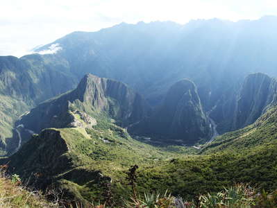 Urubamba Valley with Machu Picchu and Cordillera Urubamba
 Panoramic view from Montaña Machu Picchu, with the Urubamba Range in the background. The Río Uruba...") Urubamba Valley with Machu Picchu and Cordillera Urubamba
Urubamba Valley with Machu Picchu and Cordillera Urubamba View from Montaña Machu Picchu in SW direction to the glacierized Cordillera Vilcabamba with Padrey...") Cordillera Vilcabamba with Padreyoc
Cordillera Vilcabamba with Padreyoc View from Montaña Machu Picchu in SW direction to the glacierized Cordillera Vilcabamba (vicinity o...") Cordillera Vilcabamba near Padreyoc
Cordillera Vilcabamba near Padreyoc View from Montaña Machu Picchu in SW direction to the glacierized Cordillera Vilcabamba with Padrey...") Cordillera Vilcabamba | Padreyoc
Cordillera Vilcabamba | Padreyoc View from the summit area of Montaña Machu Picchu in N direction to the glacierized NE face of Neva...") Cordillera Vilcabamba | Nevado Salkantay
Cordillera Vilcabamba | Nevado Salkantay View from Montaña Machu Picchu. Even though some aspects of its history remain unclear, Machu Picch...") Machu Picchu with Huayna Picchu and Río Urubamba
Machu Picchu with Huayna Picchu and Río Urubamba View from the slopes of Montaña Machu Picchu. Even though some aspects of its history remain unclea...") Machu Picchu with Huayna Picchu and Río Urubamba
Machu Picchu with Huayna Picchu and Río Urubamba View from Montaña Machu Picchu. Even though some aspects of its history remain unclear, Machu Picch...") Machu Picchu
Machu Picchu An endless stairway leads up to Montaña Machu Picchu (3082 m). Machu Picchu (2430 m asl.) and Huayn...") Urubamba Valley | Descent from Montaña Machu Picchu
Urubamba Valley | Descent from Montaña Machu Picchu Located on a ridge above the meandering Urubamba River at 2430 m asl., Machu Picchu is most commonly...") Machu Picchu with Huayna Picchu
Machu Picchu with Huayna Picchu Viewpoint near Intihuatana, view in NE direction to Putucusi (2560 m) and to the Cordillera Urubamba") Machu Picchu | Intipampa and lower town
Machu Picchu | Intipampa and lower town Machu Picchu, located at 2430 m asl., is most commonly considered an Inca citadel in operation durin...") Machu Picchu | Terraces and Montaña Machu Picchu
Machu Picchu | Terraces and Montaña Machu Picchu View from Mt. Archer towards west") Rockhampton
Rockhampton Xanthorrhoea sp. (grasstree)") Mount Archer | Xanthorrhoea
Mount Archer | Xanthorrhoea Location: near Broken River") Eungella NP | Buttresses
Eungella NP | Buttresses View from the Mackay - Eungella Road") Eungella NP | Tree ferns
Eungella NP | Tree ferns Ornithorhynchus anatinus is one of only four species of egg-laying mammals. This peculiar semi-aquat...") Eungella NP | Broken River with platypus
Eungella NP | Broken River with platypus Ornithorhynchus anatinus is one of only four species of egg-laying mammals. This peculiar semi-aquat...") Eungella NP | Broken River with platypus
Eungella NP | Broken River with platypus Late afternoon view from the Eungella Dam Road towards east") Pioneer Valley panorama
Pioneer Valley panorama Sugar cane farming and processing is one of the major economic activities in the area of Proserpine.") Proserpine | Sugar cane field
Proserpine | Sugar cane field Sugar cane farming and processing is one of the major economic activities in the area of Proserpine.") Proserpine | Sugar cane field and sugar mill
Proserpine | Sugar cane field and sugar mill Coconut palms (Cocos nucifera) in the foreground") Airlie Beach
Airlie Beach View towards northeast to some of the Whitsunday Islands appearing in the background of the image.") Shute Harbour and mangrove belt
Shute Harbour and mangrove belt View towards northeast. The mainland with Shute Harbour appears near the left edge of the image. The...") Whitsunday Islands
Whitsunday Islands View towards south") Whitsunday Islands | Long Island
Whitsunday Islands | Long Island View towards south") Whitsunday Islands | Long Island
Whitsunday Islands | Long Island View towards southeast. Hamilton Island is the most populated of all the Whitsunday Islands.") Whitsunday Islands | Hamilton Island
Whitsunday Islands | Hamilton Island View towards southwest, the Hill Inlet appears in the left portion of the image. With a surface area...") Whitsunday Island with Hill Inlet
Whitsunday Island with Hill Inlet View towards southwest, the Hill Inlet appears near the left edge of the image. With a surface area ...") Whitsunday Island with Hill Inlet
Whitsunday Island with Hill Inlet View towards south, the Hill Inlet and Whitehaven Beach appear in the centre of the image. With a su...") Whitsunday Island with Hill Inlet and Whitehaven Beach
Whitsunday Island with Hill Inlet and Whitehaven Beach View towards south, the Hill Inlet and Whitehaven Beach appear in the left background. With a surfac...") Whitsunday Island
Whitsunday Island Nymphaea sp. (water lily) in a lagoon near highway A1 (Bruce Highway). The same lagoon is home also ...") Ingham | Nymphaea
Ingham | Nymphaea Nymphaea sp. (water lily) in a lagoon near highway A1 (Bruce Highway). The same lagoon is home also ...") Ingham | Nymphaea
Ingham | Nymphaea Innisfail is well known for its sugar industry.") Innisfail | Sugar cane railway
Innisfail | Sugar cane railway This diatreme is approx. 80 m deep.") Atherton Tablelands | Mt. Hypipamee Crater
Atherton Tablelands | Mt. Hypipamee Crater Location: near Millaa Millaa Falls at an elevation of approx. 800 m asl.") Atherton Tablelands | Pasture land
Atherton Tablelands | Pasture land Location: near Millaa Millaa. Cattle farming is an important economy in the Atherton Tablelands.") Atherton Tablelands | Unicorn
Atherton Tablelands | Unicorn 18 m high waterfall near to the town of Millaa Millaa") Atherton Tablelands | Millaa Millaa Falls
Atherton Tablelands | Millaa Millaa Falls Location: near Millaa Millaa") Atherton Tablelands | Tropical rainforest with buttresses
Atherton Tablelands | Tropical rainforest with buttresses Atherton Tablelands, view from the Skyrail Rainforest Cableway towards south. This rainforest has be...") Kuranda | Tropical rainforest
Kuranda | Tropical rainforest Atherton Tablelands, view from the Skyrail Rainforest Cableway. This rainforest has been part of the...") Kuranda | Tropical rainforest canopy
Kuranda | Tropical rainforest canopy Atherton Tablelands, view from the Skyrail Rainforest Cableway. This rainforest has been part of the...") Kuranda | Tropical rainforest canopy
Kuranda | Tropical rainforest canopy Atherton Tablelands, view from the Skyrail Rainforest Cableway. This rainforest has been part of the...") Kuranda | Tropical rainforest canopy
Kuranda | Tropical rainforest canopy Atherton Tablelands, view from the Skyrail Rainforest Cableway. This rainforest has been part of the...") Kuranda | Tropical rainforest canopy
Kuranda | Tropical rainforest canopy Atherton Tablelands, view from the Skyrail Rainforest Cableway. This rainforest has been part of the...") Kuranda | Tropical rainforest emergent
Kuranda | Tropical rainforest emergent Atherton Tablelands, near the Red Peak Station of the Skyrail Rainforest Cableway. The Queensland ka...") Kuranda | Trunk of Agathis robusta
Kuranda | Trunk of Agathis robusta This rainforest has been part of the Wet Tropics of Queensland UNESCO World Heritage Site since 1988...") Kuranda | Rainforest reflecting in Barron River
Kuranda | Rainforest reflecting in Barron River Late afternoon view from Rex Lookout (Captain Cook Highway) towards southeast") Cairns | Wangetti Beach
Cairns | Wangetti Beach Sunrise view towards south. The cloud-topped mountain in the left central background is Black Mounta...") Port Douglas | Four Mile Beach
Port Douglas | Four Mile Beach Sunrise view towards south. The cloud-topped mountain in the left central background is Black Mounta...") Port Douglas | Four Mile Beach
Port Douglas | Four Mile Beach Sunrise view towards south") Port Douglas | Four Mile Beach
Port Douglas | Four Mile Beach Panoramic morning view from Flagstaff Hill towards south. The cloud-topped mountain in the right cen...") Port Douglas with Four Mile Beach
Port Douglas with Four Mile Beach Panoramic morning view from Flagstaff Hill towards south") Port Douglas | Four Mile Beach
Port Douglas | Four Mile Beach This small timber church dates back to 1914. In 1988 it was relocated from its original place to for...") Port Douglas | St. Mary's by the Sea
Port Douglas | St. Mary's by the Sea View from The Reef Marina across Dickson Inlet towards west. The mountains of the Great Dividing Ran...") Port Douglas | Mangroves
Port Douglas | Mangroves Sunrise view") Mossman | Early morning
Mossman | Early morning Sunrise view to the mountains of the Great Dividing Range") Mossman | Early morning
Mossman | Early morning The plains around Mossman are used for growing sugar cane. The northernmost sugar mill of Australia'...") Mossman | Sugar cane harvest
Mossman | Sugar cane harvest Cultivation of Musa sp. The Great Dividing Range appears in the background.") Mossman | Banana cultivation
Mossman | Banana cultivation Daintree NP, declared as a UNESCO World Heritage Site in 1988 as part of the Wet Tropics of Queensla...") Manjal Jimalji | Tropical rainforest
Manjal Jimalji | Tropical rainforest Daintree NP, declared as a UNESCO World Heritage Site in 1988 as part of the Wet Tropics of Queensla...") Manjal Jimalji | Tropical rainforest
Manjal Jimalji | Tropical rainforest Daintree NP, declared as a UNESCO World Heritage Site in 1988 as part of the Wet Tropics of Queensla...") Manjal Jimalji | Coral fern patch with granite outcrop
Manjal Jimalji | Coral fern patch with granite outcrop Daintree NP, declared as a UNESCO World Heritage Site in 1988 as part of the Wet Tropics of Queensla...") Manjal Jimalji | Coral fern patch with granite outcrop
Manjal Jimalji | Coral fern patch with granite outcrop Daintree NP, declared as a UNESCO World Heritage Site in 1988 as part of the Wet Tropics of Queensla...") Manjal Jimalji | Coral fern patch and Mossman coast
Manjal Jimalji | Coral fern patch and Mossman coast Tidal zone, view to Cape Tribulation in northeastern direction") Cape Tribulation and Myall Beach
Cape Tribulation and Myall Beach Tidal zone, view towards southwest") Cape Tribulation | Myall Beach
Cape Tribulation | Myall Beach Another scenic beach along Queensland's northeastern coast") Cape Tribulation | Thornton Beach
Cape Tribulation | Thornton Beach Location: close to Cape Tribulation, view towards northwest") Cape Tribulation Beach
Cape Tribulation Beach Location: near Cape Tribulation") Mt. Sorrow | Tropical rainforest with buttresses
Mt. Sorrow | Tropical rainforest with buttresses Location: near Cape Tribulation") Mt. Sorrow | Tropical rainforest with buttresses
Mt. Sorrow | Tropical rainforest with buttresses Location: near Cape Tribulation") Mt. Sorrow | Tropical rainforest with cycad
Mt. Sorrow | Tropical rainforest with cycad View from Mt. Sorrow (near Cape Tribulation, 683 m) towards southeast down to the Coral Sea") Mt. Sorrow lookout
Mt. Sorrow lookout View from Alexandra Lookout (Cape Tribulation Road) towards south where the Daintree River drains in...") Daintree River mouth
Daintree River mouth View from Alexandra Lookout (Cape Tribulation Road) towards south where the Daintree River drains in...") Daintree River mouth
Daintree River mouth Small lateral branch of the river") Daintree River with mangroves
Daintree River with mangroves Ceyx azureus") Daintree River | Azure kingfisher
Daintree River | Azure kingfisher The saltwater crocodile (Crocodylus porosus) is the largest living reptile and the largest riparian ...") Daintree River | Be careful in the mangroves
Daintree River | Be careful in the mangroves The saltwater crocodile (Crocodylus porosus) is the largest living reptile and the largest riparian ...") Daintree River | Old saltwater crocodile
Daintree River | Old saltwater crocodile The saltwater crocodile (Crocodylus porosus) is the largest living reptile and the largest riparian ...") Daintree River | Old saltwater crocodile
Daintree River | Old saltwater crocodile The saltwater crocodile (Crocodylus porosus) is the largest living reptile and the largest riparian ...") Daintree River | Old saltwater crocodile
Daintree River | Old saltwater crocodile Location: Chemin Bras-Pétard. Sugar cane is cultivated in many places along the coastal plains and ...") Bras-Panon | Sugar cane harvest
Bras-Panon | Sugar cane harvest The Grand Brûlé extends for eight kilometres along the east coast and lower slopes of La Réunion....") Forêt domaniale du Grand Brûlé | Lava flow
Forêt domaniale du Grand Brûlé | Lava flow View towards south. The Grand Brûlé extends for eight kilometres along the east coast and lower sl...") Forêt domaniale du Grand Brûlé
Forêt domaniale du Grand Brûlé View towards west, the summit area of the Piton de la Fournaise is hidden by the clouds. The Grand B...") Forêt domaniale du Grand Brûlé | Lava flow of 2007
Forêt domaniale du Grand Brûlé | Lava flow of 2007 View towards northeast. The position of the coastline - and therefore the size of the island - is de...") Le Puits-Arabe | Volcanic coast
Le Puits-Arabe | Volcanic coast View towards southwest. The position of the coastline - and therefore the size of the island - is de...") Le Puits-Arabe | Volcanic coast
Le Puits-Arabe | Volcanic coast Vacoa (Pandanus utilis) is commonly encountered in the coastal ecosystems of La Réunion. For good r...") Le Puits-Arabe | Vacoa trees
Le Puits-Arabe | Vacoa trees View from the summit area of Piton des Neiges across the Cirque de Cilaos with Cilaos in southern di...") Cirque de Cilaos | Panoramic view
Cirque de Cilaos | Panoramic view View from the summit area of Piton des Neiges southeast. Piton de la Fournaise (2632 m) is seen in t...") Cirque de Cilaos | Panoramic view
Cirque de Cilaos | Panoramic view View from the summit area of Piton des Neiges towards southeast. Piton de la Fournaise (2632 m) appe...") Piton de la Fournaise
Piton de la Fournaise The northeastern slopes of La Réunion are fully exposed to the raising air masses brought by the tr...") Plateau de Duvernay and Cassé de Takamaka
Plateau de Duvernay and Cassé de Takamaka The northeastern slopes of La Réunion are fully exposed to the raising air masses brought by the tr...") Le Trou de Fer
Le Trou de Fer The northeastern slopes of La Réunion are fully exposed to the raising air masses brought by the tr...") Le Trou de Fer
Le Trou de Fer The northeastern slopes of La Réunion are fully exposed to the raising air masses brought by the tr...") Forêt de Bélouve
Forêt de Bélouve The northeastern slopes of La Réunion are fully exposed to the raising air masses brought by the tr...") Forêt de Bélouve
Forêt de Bélouve The northeastern slopes of La Réunion are fully exposed to the raising air masses brought by the tr...") Forêt de Bélouve
Forêt de Bélouve The northeastern slopes of La Réunion are fully exposed to the raising air masses brought by the tr...") Forêt de Bélouve
Forêt de Bélouve The northeastern slopes of La Réunion are fully exposed to the raising air masses brought by the tr...") Forêt de Bélouve
Forêt de Bélouve The eastern slopes of La Réunion are exposed to raising air masses brought by the tradewinds. Frequ...") Forêt de Bébour
Forêt de Bébour View from Col du Bébour towards southeast. The eastern slopes of La Réunion are fully exposed to t...") Col du Bébour | Montane rainforest
Col du Bébour | Montane rainforest View from Nez Coupé de Sainte-Rose to the Plaine des Osmondes (centre) and Piton de Crac (right, 13...") Plaine des Osmondes and Piton de Crac
Plaine des Osmondes and Piton de Crac View from the Nez Coupé de Sainte-Rose to the Plaine des Osmondes and the Piton de Crac (1368 m). L...") Plaine des Osmondes and Piton de Crac
Plaine des Osmondes and Piton de Crac View from the summit cone of the Piton de la Fournaise (trail to Cratère Dolomieu) to a lava flow o...") Le Grand Brûlé with Indian Ocean
Le Grand Brûlé with Indian Ocean View from the Moulawella hilltop over the pristine tropical rainforests of the UNESCO-listed Sinhara...") Sinharaja Forest Reserve | Tropical rainforest
Sinharaja Forest Reserve | Tropical rainforest Characterized by pristine tropical rainforest - the last of its type in Sri Lanka - the UNESCO-liste...") Sinharaja Forest Reserve | Tropical rainforest
Sinharaja Forest Reserve | Tropical rainforest Characterized by pristine tropical rainforest - the last of its type in Sri Lanka - the UNESCO-liste...") Sinharaja Forest Reserve | Tropical rainforest
Sinharaja Forest Reserve | Tropical rainforest Characterized by pristine tropical rainforest - the last of its type in Sri Lanka - the UNESCO-liste...") Sinharaja Forest Reserve | Rainforest leaves
Sinharaja Forest Reserve | Rainforest leaves Characterized by pristine tropical rainforest - the last of its type in Sri Lanka - the UNESCO-liste...") Sinharaja Forest Reserve | Dillenia triquetra
Sinharaja Forest Reserve | Dillenia triquetra Flower of Dipterocarpus hispidus. Characterized by pristine tropical rainforest - the last of its ty...") Sinharaja Forest Reserve | Dipterocarpus hispidus
Sinharaja Forest Reserve | Dipterocarpus hispidus Characterized by pristine tropical rainforest - the last of its type in Sri Lanka - the UNESCO-liste...") Sinharaja Forest Reserve | Dipterocarpus zeylanicus
Sinharaja Forest Reserve | Dipterocarpus zeylanicus Fruit of Dipterocarpus zeylanicus. Characterized by pristine tropical rainforest - the last of its t...") Sinharaja Forest Reserve | Dipterocarpus zeylanicus
Sinharaja Forest Reserve | Dipterocarpus zeylanicus Characterized by pristine tropical rainforest - the last of its type in Sri Lanka - the UNESCO-liste...") Sinharaja Forest Reserve | Fruit of Shorea sp.
Sinharaja Forest Reserve | Fruit of Shorea sp. Characterized by pristine tropical rainforest - the last of its type in Sri Lanka - the UNESCO-liste...") Sinharaja Forest Reserve | Fern
Sinharaja Forest Reserve | Fern Nepenthes distillatoria. Characterized by pristine tropical rainforest - the last in Sri Lanka - the...") Sinharaja Forest Reserve | Pitcher plant
Sinharaja Forest Reserve | Pitcher plant Nepenthes distillatoria. Characterized by pristine tropical rainforest - the last in Sri Lanka - the...") Sinharaja Forest Reserve | Pitcher plant
Sinharaja Forest Reserve | Pitcher plant Characterized by pristine tropical rainforest - the last of its type in Sri Lanka - the UNESCO-liste...") Sinharaja Forest Reserve | Earth worm
Sinharaja Forest Reserve | Earth worm Characterized by pristine tropical rainforest - the last of its type in Sri Lanka - the UNESCO-liste...") Sinharaja Forest Reserve | Reflections
Sinharaja Forest Reserve | Reflections Characterized by pristine tropical rainforest - the last of its type in Sri Lanka - the UNESCO-liste...") Sinharaja Research Centre
Sinharaja Research Centre Characterized by pristine tropical rainforest - the last of its type in Sri Lanka - the UNESCO-liste...") Sinharaja Forest Reserve | Scientist
Sinharaja Forest Reserve | Scientist The tropical highland climate of Fort Portal (approx. 1500 m asl) is ideal for the production of hig...") Fort Portal | Tea cultivation
Fort Portal | Tea cultivation The \"Lake of Frogs\" is one of numerous crater lakes characteristic for the volcanic landscape betwee...") Lake Nyabikere | Morning fog
Lake Nyabikere | Morning fog Lake Nyinambuga is one of numerous crater lakes characteristic for the volcanic landscape between Fo...") Lake Nyinambuga
Lake Nyinambuga Rainforest trees generally have a shallow root system in order to allow uptake of nutrients from the...") Kibale NP | Rainforest with buttresses
Kibale NP | Rainforest with buttresses Rainforest trees generally have a shallow root system in order to allow uptake of nutrients from the...") Kibale NP | Rainforest with buttresses
Kibale NP | Rainforest with buttresses") Kibale NP | Rainforest with buttresses
Kibale NP | Rainforest with buttresses The two species of chimpanzees (the image shows a common chimpanzee Pan troglodytes) are the closest...") Kibale NP | Chimpanzee
Kibale NP | Chimpanzee