Home / The world in change
Our world is in a permanent state of change. The sequence of day and night and, in many regions of the world, the course of the seasons, or along the coasts also the tides, follow a strictly cyclic pattern, governing the function of society as well as of many ecosystems. Geological processes, in contrast, often act at time scales hardly observable within a human lifespan. Sometimes, however, they occur rapidly, such as landslides or volcanic eruptions. The cryosphere reacts to climatic signals in a sensitive way - one may observe the retreat or advance of glaciers at time scales of years. Ecosystems may evolve over long periods, but can also change suddenly through natural or anthropogenic disturbances. Also the dynamics of anthropogenic structures - or systems such as cities - may operate at a broad variety of time scales.
This site illustrates time lapse image comparisons of our ever changing world. Topics range from glacial retreat to urban development, and the time spans range from few hours to more than one decade. More time lapes comparison are accessible through the keyword time series.
The technical implementation of the slider builds on the code provided on the web site of Lea Verou.


Rhone Glacier, Valais, Switzerland
4 September 2013 | 21 August 2021
Please drag the slider at the bottom of the image to the left or right side in order to see the change over time. Note that this functionality may not work on mobile devices.
The Rhonegletscher has experienced a dramatic retreat since the maximum of the Little Ice Age in the mid 19th Century, when its terminus was not far from the village of Gletsch. The proglacial lake seen in these 2013 and 2021 photos started to form around 2006, and has since experienced a rapid growth. Part of the glacier tongue is covered by a fibrous web, with the intention to reduce melting and enable the operation of an ice tunnel for touristic purposes.


Pasterze, Carinthia, Austria
22 June 2008 | 5 July 2020
Please drag the slider at the bottom of the image to the left or right side in order to see the change over time. Note that this functionality may not work on mobile devices.
View from Franz-Josefs-Höhe to Austria's largest glacier with Groβglockner (left, 3798 m) and Glocknerwand (right, 3722 m) behind, and Johannisberg (3460 m) in the background. Massive recession of the Pasterze has led to the rapid formation of a large proglacial lake, mainly in the second half of the 2010s.


Fox Glacier, South Island of New Zealand
7 February 2014 | 6 February 2015 | 5 January 2016 | 14 February 2017
Please drag the sliders at the bottom of the images to the left or right side in order to see the change over time. Note that this functionality may not work on mobile devices.
Fox Glacier is experiencing a dramatic degree of retreat, as the series of three images taken at an interval of less than two years illustrate. Particularly the first interval of almost exactly one year displays a massive loss of ice. The second interval shows a substantial decrease of glacier thickness over the remaining part of the tongue.
Fed by the tremendous amount of precipitation occurring where the moist westerly air masses meet the Southern Alps, this glacier still approached the western mountain foreland few decades ago, but now rapidly retreats up a narrow valley. A detailed look at the images reveals a lot of ongoing slope processes, most probably related to the debuttressing effects through glacier melting.
A couple of kilometres northeast of Fox glacier, a similar behaviour is observed for the Franz Josef Glacier.
Image of 7 February 2014:
Courtesy of Julia Krenn
Image of 5 January 2016:
Courtesy of Matthias Benedikt
Image of 14 February 2017:
Courtesy of Gisela Eberhard
Access Image of 6 February 2015 ![]()


Laguna Grande and Glaciar Torre, Patagonia, Argentina
2 December 2006 | 25 February 2016
Please drag the slider at the bottom of the image to the left or right side in order to see the change over time. Note that this functionality may not work on mobile devices.
This glacier in the Andes of southern Patagonia has suffered retreat and thinning over the past decade. As a consequence, the associated proglacial lake has increased in size, and the morphology of the landscape has changed. Most notably, the slope in the very left portion of the image was sliding down (indicated by the vegetation) and a small lake evolved in the right portion of the image. Viewpoint: Mirador Maestri.


Glaciar Perito Moreno, Patagonia, Argentina
4 December 2006 | 23 February 2016
Please drag the slider at the bottom of the image to the left or right side in order to see the change over time. Note that this functionality may not work on mobile devices.
This glacier is approximately 250 square kilometres large and 30 kilometres long. It originates at the Southern Patagonian Ice Field and calves into Lago Argentino along an ice front of 5 km length which sometimes impounds one branch of the lake, leading to episodic breakthroughs.The Perito Moreno Glacier is one of few glaciers worldwide having remained largely stable throughout the past decade.


Lago di Lugano, Ticino, Switzerland
11 May 2013 7:03 | 11 May 2013 8:01
Please drag the slider at the bottom of the image to the left or right side in order to see the change over time. Note that this functionality may not work on mobile devices.
Views from Sighignola to the lake and the town of Lugano just before and after disappearance of the morning fog. Left centre: Monte San Salvatore (912 m), background: Lago Maggiore and Valais Alps.
Access
Image of 7:03 ![]() |
Image of 8:01
|
Image of 8:01 ![]()


Volcanic eruption, Piton de la Fournaise, La Réunion
9 September 2016 | 11 September 2016
Please drag the slider at the bottom of the image to the left or right side in order to see the change over time. Note that this functionality may not work on mobile devices.
Views from Nez Coupé de Sainte-Rose to the central cone of this highly active shield volcano. The first image was taken two days before the onset of a fissure eruption. The second photograph was taken 6:05 hours after the eruption had started and shows the lava flows ploughing through the caldera Enclos Fouqué in the foreground.
Access
Image of 9 September 2016 ![]() |
Image of 11 September 2016
|
Image of 11 September 2016 ![]()


Volcanic eruption, Piton de la Fournaise, La Réunion
9 September 2016 | 11 September 2016
Please drag the slider at the bottom of the image to the left or right side in order to see the change over time. Note that this functionality may not work on mobile devices.
Views from Rempart de Bellecombe between Piton de Partage and Nez Coupé de Sainte-Rose to the central cone of this highly active shield volcano. The first image was taken two days before the onset of a fissure eruption. The second photograph was taken 4:47 hours after the eruption had started.
Access
Image of 9 September 2016 ![]() |
Image of 11 September 2016
|
Image of 11 September 2016 ![]()


Volcanic eruption, Piton de la Fournaise, La Réunion
11 September 2016 | 16 September 2016
Please drag the slider at the bottom of the image to the left or right side in order to see the change over time. Note that this functionality may not work on mobile devices.
Views from Rempart de Bellecombe between Piton de Partage and Nez Coupé de Sainte-Rose to the main lava plume of the eruption. The first image was taken 7:32 hours after the onset of the fissure eruption. Five days later, the volcanic activity was concentrated at one spot. Material ejected there had piled up to a cone of considerable dimensions.
Access
Image of 11 September 2016 ![]() |
Image of 16 September 2016
|
Image of 16 September 2016 ![]()


Tides at Milford Sound, South Island, New Zealand
3 February 2015 | 7 February 2015
Please drag the slider at the bottom of the image to the left or right side in order to see the change over time. Note that this functionality may not work on mobile devices.
The tides lead to sea level variations of typically approx. 2 m along the shores of Milford Sound (Piopiotahi in the Maori language), often considered one of the most scenic places in the world. The tidal zone occupies a broad belt in the flat back shore, where Cleddau River transports a substantial amount of sediment into the fiord.


Tides at the Seine Estuary, Normandie, France
29 August 2013 13:03 | 29 August 2013 16:04
Please drag the slider at the bottom of the image to the left or right side in order to see the change over time. This functionality may not work on mobile devices.
Sea level variations due to the tides exceed seven metres in the place where the Seine flows into the Channel near Le Havre. The two images were taken at an interval of three hours. Viewpoint: Pont de Normandie.
Access
Image of 13:03 ![]() |
Image of 16:04
|
Image of 16:04 ![]()


Viaduc de Trois-Bassins, Route des Tamarins, La Réunion
4 September 2016 | 10 September 2016
Please drag the slider at the bottom of the image to the left or right side in order to see the change over time. Note that this functionality may not work on mobile devices.
Morning and evening views from near Le Barrage towards west to the Route des Tamarins, part of the motorway connection between Saint-Denis and Saint-Pierre (opened in 2009). The town seen in the right central background is La Saline les Bains.
Access
Image of 4 September 2016 ![]() |
Image of 10 September 2016
|
Image of 10 September 2016 ![]()

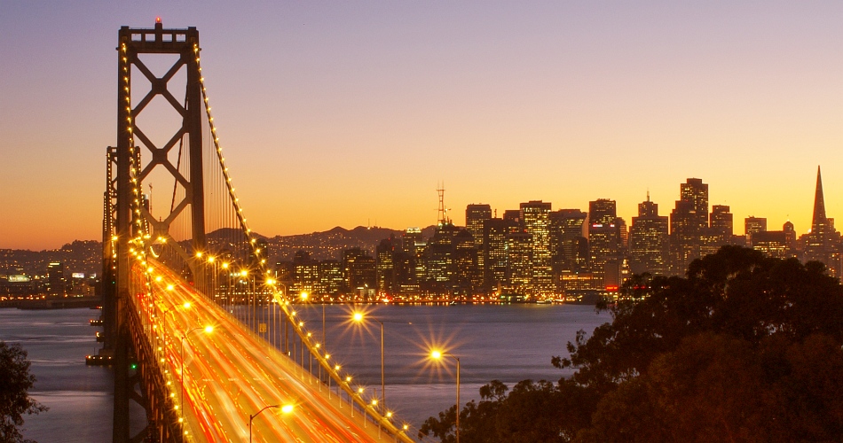
San Francisco-Oakland Bay Bridge, California, USA
4 October 2007 | 5 October 2007
Please drag the slider at the bottom of the image to the left or right side in order to see the change over time. Note that this functionality may not work on mobile devices.
Morning and evening views of the western part of the link between San Francisco and Oakland, crossing the San Francisco Bay. Traffic passing over the sequence of two suspension bridges dating back to the 1930s is heavy at both times of the day. The skyline of San Francisco appears in the background. Viewpoint: Yerba Buena Island.


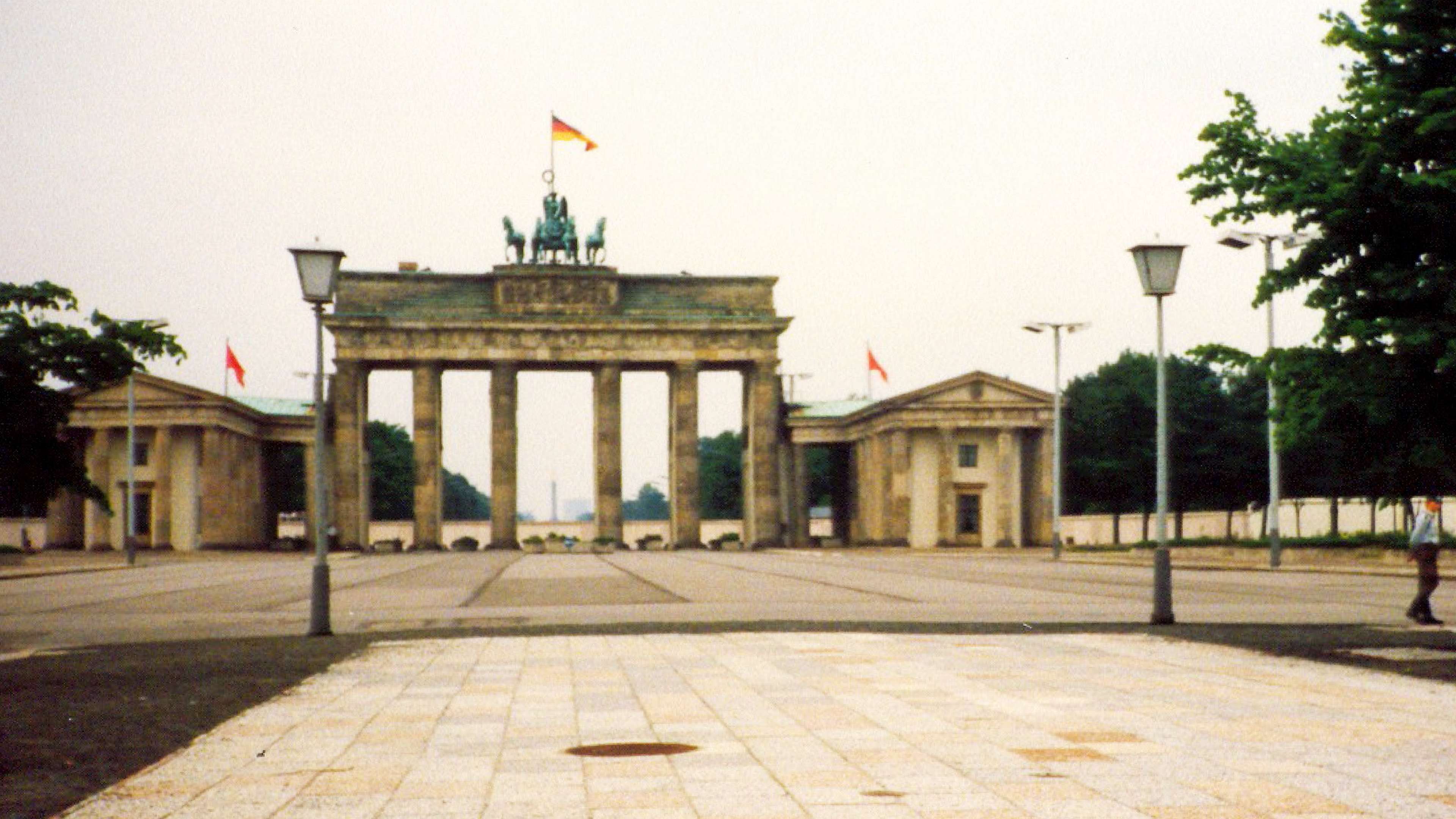
Brandenburg Gate seen from the West, Berlin, Germany
April 1988 | 29 October 2021
Please drag the slider at the bottom of the image to the left or right side in order to see the change over time. Note that this functionality may not work on mobile devices.
View in E direction to the Brandenburg Gate, a Neoclassic monument completed in 1791. It has witnessed various important events of European history in its immediate vicinity. Located directly adjacent to the Berlin Wall from 1961 to 1989, the gate is now, after the German reunification, often considered a symbol for peace and unity.
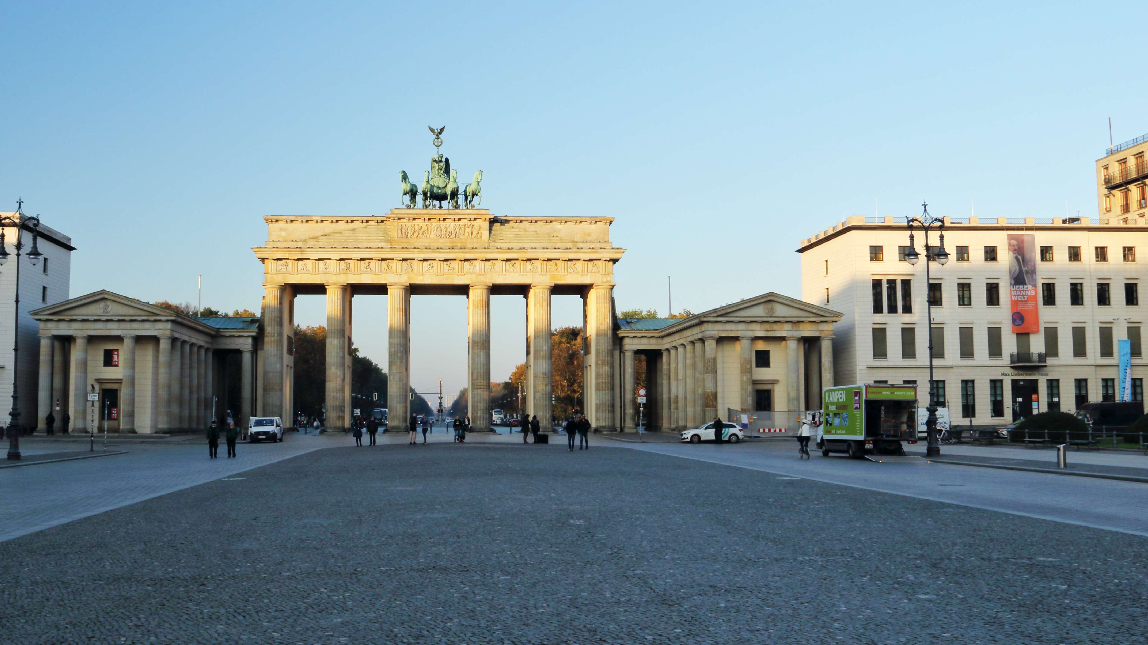
Brandenburg Gate seen from the East, Berlin, Germany
April 1988 | 29 October 2021
Please drag the slider at the bottom of the image to the left or right side in order to see the change over time. Note that this functionality may not work on mobile devices.
View from East Berlin in W direction. The Brandenburg Gate represents a Neoclassic monument completed in 1791. It has witnessed various important events of European history in its immediate vicinity. Located directly adjacent to the Berlin Wall from 1961 to 1989 (seen in the background of the 1988 photo), the gate has later, after the German reunification, become a symbol for peace and unity.


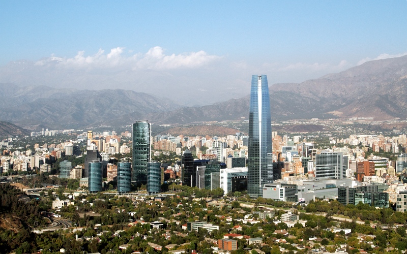
One decade of change in Santiago de Chile
7 May 2006 | 28 February 2016
Please drag the slider at the bottom of the image to the left or right side in order to see the change over time. Note that this functionality may not work on mobile devices.
Views from Cerro San Cristóbal over the city centre. Whilst part of the urban landscape remained unchanged over the time span of 10 years, tall buildings were constructed in other areas.

Urban development in the Barrio Alto, Santiago de Chile
8 October 2006 | 13 February 2016
Please drag the slider at the bottom of the image to the left or right side in order to see the change over time. Note that this functionality may not work on mobile devices.
The Barrio Alto, with the neighbourhoods of Providencia and Las Condes, has served as an upper class residential and business district throughout most of the history of Santiago. Substantial investments during the past decade have resulted in a spectacular skyline dominated by the Gran Torre de Santiago, one of the tallest buildings of the Southern Hemisphere. View from Mirador El Hundimiento (Cerro San Cristóbal).


Maria-Theresien-Strasse, Innsbruck, Austria
2001 | 30 August 2015
Please drag the slider at the bottom of the image to the left or right side in order to see the change over time. Note that this functionality may not work on mobile devices.
One of the main representative and shopping lanes of the capital town of the Austrian province of Tirol. The images do not only show the seasonal variation of snow cover on the slopes of the Karwendel Mountains in the background, but also the change of the layout of the road within the 15 years time span: the Maria-Theresien-Strasse was converted into a pedestrian zone in the period between 2006 and 2009.
Access
Image of 2001 ![]() |
Image of 30 August 2015
|
Image of 30 August 2015 ![]()