

 Patches of the yungas forest occupying damp ravines near the treeline at approx. 2100-2200 m asl. Mo...") Tafí del Valle | Treeline area
Tafí del Valle | Treeline area View from the Provincial Road 307 in S direction down to the Valle de Tafí with Tafí del Valle and...") Valle de Tafí with Lago El Mollar
Valle de Tafí with Lago El Mollar View from the Provincial Road 307 in S direction down to the Valle de Tafí with Tafí del Valle and...") Valle de Tafí with Lago El Mollar
Valle de Tafí with Lago El Mollar View from the Provincial Road 307 in S direction down to the Valle de Tafí with Tafí del Valle and...") Valle de Tafí with Lago El Mollar
Valle de Tafí with Lago El Mollar View from the Provincial Road 307 in NW direction") Sierra de Aconquija with mountain pastures
Sierra de Aconquija with mountain pastures View from the Provincial Road 307 in SW direction to the Sierra de Aconquija. Llamas are kept as liv...") Abra del Infernillo | Alpine grassland with llamas
Abra del Infernillo | Alpine grassland with llamas Llamas are kept as livestock in this area at approx. 3000 m asl.") Abra del Infernillo | Llamas
Abra del Infernillo | Llamas View from the Finca Las Nubes across the Valles Calchaquíes in NE direction") Cafayate | Foehn clouds
Cafayate | Foehn clouds This village received its name due to the German workers constructing the railway from Salta through...") Valle de Lerma | Alemanía
Valle de Lerma | Alemanía The Valle de Lerma is an important agricultural area. Unfortunately, rather unhealthy products are c...") Valle de Lerma | Tobacco cultivation
Valle de Lerma | Tobacco cultivation View from Cerro San Bernardo over the city of Salta, the main urban centre of the Valle de Lerma, in...") Valle de Lerma with Salta
Valle de Lerma with Salta View from National Road 52 upstream") Quebradilla de Purmamarca
Quebradilla de Purmamarca") Río Magdalena Valley | Rice field
Río Magdalena Valley | Rice field View from the road Hobo-Gigante") Upper Río Magdalena valley
Upper Río Magdalena valley") Chinchiná | Guayabal coffee farm
Chinchiná | Guayabal coffee farm") Chinchiná | Guayabal coffee farm
Chinchiná | Guayabal coffee farm") Cartago | Cultural landscape
Cartago | Cultural landscape Carica papaya") Cauca valley | Papaya cultivation
Cauca valley | Papaya cultivation") Cauca Valley | Sugar cane cultivation
Cauca Valley | Sugar cane cultivation") Cauca Valley | Umbrella trees
Cauca Valley | Umbrella trees This important suspension bridge crossing the Río Cauca few kilometres S of Santa Fe was closed for...") Santa Fe de Antioquia | Puente Paso Real
Santa Fe de Antioquia | Puente Paso Real Panoramic view in NW direction, downstream the Río Cauca. At the time of completion in 1895, this h...") Santa Fe de Antioquia | Puente de Occidente
Santa Fe de Antioquia | Puente de Occidente At the time of completion in 1895, this hybrid suspension/cable-stayed bridge had the longest span i...") Santa Fe de Antioquia | Puente de Occidente
Santa Fe de Antioquia | Puente de Occidente View from El Junco across the Río Cauca in W direction to the Cordillera Occidental. Rain shade eff...") Cauca Valley with El Guasimo Landslide
Cauca Valley with El Guasimo Landslide Flight Lisboa - Praia, view over Praia Baixo (bottom of the photo) in NW direction to the mountainou...") Santiago | Aerial view of the northeast coast
Santiago | Aerial view of the northeast coast Flight Lisboa - Praia, view in NW direction along the NE coast of Cape Verde's main island. As it is...") Santiago | Aerial view of the northeast coast
Santiago | Aerial view of the northeast coast Flight São Filipe - Praia, view in NE direction to the coastal village of Porto Mosquito and up the...") Santiago | Aerial view of the southwest coast
Santiago | Aerial view of the southwest coast Flight São Filipe - Praia, view over Cidadela, one of the W suburbs of the capital city of Cape Ver...") Santiago | Suburbs of Praia
Santiago | Suburbs of Praia Flight São Filipe - Praia, view in NW direction. The neighbourhood of Platô, forming the historic ...") Santiago | City centre of Praia with Platô
Santiago | City centre of Praia with Platô Flight São Filipe - Praia, view over the neighbourhoods of Achada Grande (foreground of the scene) ...") Santiago | Praia with Achada Grande and Platô
Santiago | Praia with Achada Grande and Platô Flight São Filipe - Praia, view in NW direction. The neighbourhood in the foreground consisted of j...") Santiago | Suburbs of Praia
Santiago | Suburbs of Praia The lush green of Santiago's vegetation only persists for few months each year. After the short rain...") Santiago | Landscape near Ribeirão Chiqueiro
Santiago | Landscape near Ribeirão Chiqueiro View from the fortress of Cidade Velha (Real Fortaleza de São Filipe) up the Ribeira Grande in N di...") Santiago | Ribeira Grande after sunset
Santiago | Ribeira Grande after sunset Panoramic view from the vicinity of Monte Tchota in W direction across the fluvially dissected volca...") Santiago | Western slopes of Pico d'Antónia
Santiago | Western slopes of Pico d'Antónia View from the vicinity of Monte Tchota in W direction to the community of Pico Leão and across the ...") Santiago | Western slopes of Pico d'Antónia
Santiago | Western slopes of Pico d'Antónia View from the vicinity of Monte Tchota in W direction across the fluvially dissected volcanic slopes...") Santiago | Western slopes of Pico d'Antónia
Santiago | Western slopes of Pico d'Antónia View from the road to Monte Tchota in SE direction. Note that many steep slopes are used for agricul...") Santiago | Mountain landscape near São Domingos
Santiago | Mountain landscape near São Domingos Panoramic view from the road to Monte Tchota in SE direction down to the Ribeira de São Domingos on...") Santiago | Mountain landscape near São Domingos
Santiago | Mountain landscape near São Domingos View from the road to Monte Tchota in E direction down to the Ribeira de São Domingos. The lush gre...") Santiago | Mountain landscape with Água de Gato
Santiago | Mountain landscape with Água de Gato View from the Poilão Dam up the Ribeira Seca in SW direction. The valley floor seen in the picture ...") Santiago | Ribeira Seca with Barragem de Poilão
Santiago | Ribeira Seca with Barragem de Poilão View from the Poilão Dam up the Ribeira Seca in SW direction, Pico d'Antonia (1394 m) appears in th...") Santiago | Ribeira Seca with Barragem de Poilão
Santiago | Ribeira Seca with Barragem de Poilão The Poilão Dam was completed in 2006, impounding the surface water draining through the Ribeira Sec...") Santiago | Barragem de Poilão
Santiago | Barragem de Poilão View from the vicinity of Rui Vaz in NE direction to the pronounced peak of Monte João Teves (755 m...") Santiago | Monte João Teves
Santiago | Monte João Teves View from the vicinity of Rui Vaz to São Jorge dos Órgãos and down the Ribeira de Gouvada in N di...") Santiago | São Jorge dos Órgãos and Monte João Teves
Santiago | São Jorge dos Órgãos and Monte João Teves Panoramic view from the vicinity of Purgueira in SE direction down to the Ribeira Pico d'Antónia. T...") Santiago | Ribeira Pico d'Antónia and Monte João Teves
Santiago | Ribeira Pico d'Antónia and Monte João Teves View from the vicinity of Purgueira in E direction down to the Ribeira Pico d'Antónia. The pronounc...") Santiago | Ribeira Pico d'Antónia and Monte João Teves
Santiago | Ribeira Pico d'Antónia and Monte João Teves View from the vicinity of Purgueira down to the Ribeira Pico d'Antónia. The lush green in the mount...") Santiago | Ribeira Pico d'Antónia
Santiago | Ribeira Pico d'Antónia View from Miradouro Cruz de Picos over the community of Chão Grande in SE direction to the mountain...") Santiago | Chão Grande
Santiago | Chão Grande The lush green in the mountains of Santiago only persists for few months each year. After the short ...") Santiago | Rural estate near Chão Grande
Santiago | Rural estate near Chão Grande View from Miradouro Cruz de Picos over part of the town of Assomada in W direction. The lush green o...") Santiago | Assomada
Santiago | Assomada Another view from Miradouro Cruz de Picos over the town of Assomada in W direction to Monte Brianda ...") Santiago | Assomada with Monte Brianda
Santiago | Assomada with Monte Brianda View from Miradouro Cruz de Picos over the town of Assomada in W direction. The lush green of the ve...") Santiago | Panoramic view of Assomada
Santiago | Panoramic view of Assomada Panoramic view from the mountain pass crossing the Serra Malagueta across the plateau of Santa Catar...") Santiago | Plateau of Santa Catarina with Monte Jagau
Santiago | Plateau of Santa Catarina with Monte Jagau View from the mountain pass crossing the Serra Malagueta in NW direction down to the Atlantic Ocean....") Santiago | Ribeira da Cuba
Santiago | Ribeira da Cuba A system of cliff and beach at the NE coast of Santiago") Santiago | Northeast coast near Pedra Ferro
Santiago | Northeast coast near Pedra Ferro View from the road Tarrafal - Calheta in SW direction down to the E suburbs of Tarrafal and the Atla...") Santiago | Suburbs of Tarrafal
Santiago | Suburbs of Tarrafal View from the road Tarrafal - Calheta over a large grove of Acacia trees in SW direction down to the...") Santiago | View to Fogo
Santiago | View to Fogo Flight São Filipe - Praia, view to the E slopes and E coast of the volcanic island of Fogo, with th...") Fogo with Pico do Fogo
Fogo with Pico do Fogo Flight São Filipe - Praia, view to the SE slopes and E coast of the volcanic island of Fogo. Lava f...") Fogo with Bordeira and Pico do Fogo
Fogo with Bordeira and Pico do Fogo Flight São Filipe - Praia, view to the S slopes of the volcanic island of Fogo with the village of ...") Fogo with Bordeira and Pico do Fogo
Fogo with Bordeira and Pico do Fogo Flight São Filipe - Praia, view to the S slopes of the volcanic island of Fogo with the village of ...") Fogo with Bordeira and Pico do Fogo
Fogo with Bordeira and Pico do Fogo Flight São Filipe - Praia, view over the capital town of the island of Fogo in NE direction") Fogo | Aerial view of São Filipe
Fogo | Aerial view of São Filipe View from Salto up the S slopes of the island to the Bordeira, forming the steep escarpment of a cal...") Fogo | Southern slopes with Bordeira
Fogo | Southern slopes with Bordeira View from the vicinity of Achada Fuma up the S slopes of the island of Fogo to the Bordeira, forming...") Fogo | Southern slopes near Achada Fuma
Fogo | Southern slopes near Achada Fuma Panoramic view from the vicinity of Achada Fuma (visible on the very right side) up the S slopes of ...") Fogo | Southern slopes with Achada Fuma and Bordeira
Fogo | Southern slopes with Achada Fuma and Bordeira View from the vicinity of Cabeça Fundão down the S slopes of the island to the village of Achada F...") Fogo | Southern slopes with Achada Fuma
Fogo | Southern slopes with Achada Fuma View from the vicinity of Cabeça Fundão down the S slopes of the island to the village of Achada F...") Fogo | Cinder cone and Achada Fuma
Fogo | Cinder cone and Achada Fuma View from the vicinity of Cabeça Fundão down the S slopes of the island of Fogo to the Atlantic Oc...") Fogo | Cinder cone near Achada Fuma
Fogo | Cinder cone near Achada Fuma View from the Bordeira down the S slopes of the island. This cinder cone clearly indicates the volca...") Fogo | Cinder cone near Achada Fuma
Fogo | Cinder cone near Achada Fuma View from the Bordeira down the S slopes of Fogo to the village of Achada Fuma on the right side and...") Fogo | Southern slopes with Achada Fuma
Fogo | Southern slopes with Achada Fuma View from the Bordeira down the SE slopes of Fogo to the Atlantic Ocean. The lush green of the veget...") Fogo | Southeastern slopes
Fogo | Southeastern slopes Bordeira, view down the SW slopes of Fogo to the Atlantic Ocean. The sandy material in the foregroun...") Fogo | Bordeira and southwestern slopes
Fogo | Bordeira and southwestern slopes Location: Bordeira, view in SW direction down to the sea. The kind of shrubland shown in the foregro...") Fogo | Mountain shrubland with Euphorbia tuckeyana
Fogo | Mountain shrubland with Euphorbia tuckeyana Location: Bordeira, view in SE direction down to the sea. The kind of shrubland shown in the foregro...") Fogo | Mountain shrubland with Euphorbia tuckeyana
Fogo | Mountain shrubland with Euphorbia tuckeyana Volcanic landscape near the SE corner of the Bordeira and the uppermost agricultural fields, view in...") Fogo | Bordeira near Cabeça Fundão
Fogo | Bordeira near Cabeça Fundão Volcanic landscape near the SE corner of the Bordeira and the uppermost agricultural fields, view in...") Fogo with Estância Roque and Cabeça Fundão
Fogo with Estância Roque and Cabeça Fundão Volcanic landscape near the SE corner of the Bordeira and the uppermost agricultural fields, view in...") Fogo | Lava flow of 1951 and Estância Roque
Fogo | Lava flow of 1951 and Estância Roque Panoramic view from the top of the escarpment (Bordeira) across the caldera of Fogo, which formed at...") Fogo | Chã das Caldeiras with Bordeira and Pico do Fogo
Fogo | Chã das Caldeiras with Bordeira and Pico do Fogo Panoramic view from the top of the escarpment (Bordeira) across the caldera of Fogo, which formed at...") Fogo | Chã das Caldeiras with Bordeira and Pico do Fogo
Fogo | Chã das Caldeiras with Bordeira and Pico do Fogo Panoramic view from the top of the escarpment (Bordeira) across the caldera of Fogo, which formed at...") Fogo | Chã das Caldeiras with Bordeira and Pico do Fogo
Fogo | Chã das Caldeiras with Bordeira and Pico do Fogo Panoramic view from the top of the escarpment (Bordeira) across the caldera of Fogo, which formed at...") Fogo | Chã das Caldeiras with Bordeira and Pico do Fogo
Fogo | Chã das Caldeiras with Bordeira and Pico do Fogo Panoramic view from the top of the escarpment (Bordeira) across the caldera of Fogo, which formed at...") Fogo | Chã das Caldeiras with Bordeira and Pico do Fogo
Fogo | Chã das Caldeiras with Bordeira and Pico do Fogo Panoramic view from the top of the escarpment (Bordeira) across the caldera of Fogo, which formed at...") Fogo | Chã das Caldeiras with Bordeira and Pico do Fogo
Fogo | Chã das Caldeiras with Bordeira and Pico do Fogo Pahoehoe lava produced during the most recent eruption in 2014/15") Fogo | Chã das Caldeiras with lava flow of 2014/15
Fogo | Chã das Caldeiras with lava flow of 2014/15 View from the slopes of Pico do Fogo down to Portela, one of the two villages of the community of Ch...") Fogo | Chã das Caldeiras with Portela
Fogo | Chã das Caldeiras with Portela Much of Portela, one of the two villages of the community of Chã das Caldeiras, was covered by lava...") Fogo | Portela with Pico do Fogo
Fogo | Portela with Pico do Fogo Panoramic view across the caldera of Fogo in SE direction to the stratovolcano Pico do Fogo (2829 m)...") Fogo | Chã das Caldeiras with Portela and Pico do Fogo
Fogo | Chã das Caldeiras with Portela and Pico do Fogo View along the N part of the Bordeira, the escarpment of the caldera of Fogo. Like Portela, also Ban...") Fogo | Chã das Caldeiras with Bangaeira
Fogo | Chã das Caldeiras with Bangaeira At this time of the year, the lava produced during the eruption of 2014/15 stands in sharp contrast ...") Fogo | Chã das Caldeiras with lava flow and agriculture
Fogo | Chã das Caldeiras with lava flow and agriculture Even though also other types of fruits are cultivated, grapes are the outstanding product grown in t...") Fogo | Grape cultivation at Chã das Caldeiras
Fogo | Grape cultivation at Chã das Caldeiras Even though also other types of fruits are cultivated, grapes are the outstanding product grown in t...") Fogo | Grape cultivation at Chã das Caldeiras
Fogo | Grape cultivation at Chã das Caldeiras Even though also other types of fruits are cultivated, grapes are the outstanding product grown in t...") Fogo | Grape cultivation at Chã das Caldeiras
Fogo | Grape cultivation at Chã das Caldeiras Even though also other types of fruits are cultivated, grapes are the outstanding product grown in t...") Fogo | Grape cultivation at Chã das Caldeiras
Fogo | Grape cultivation at Chã das Caldeiras Vineyard on the lower slopes of Pico do Fogo (2829 m). Even though also other types of fruits are cu...") Fogo | Pico do Fogo with vineyard
Fogo | Pico do Fogo with vineyard Vineyard on the lower slopes of Pico do Fogo (2829 m). Even though also other types of fruits are cu...") Fogo | Pico do Fogo with vineyard
Fogo | Pico do Fogo with vineyard View from the slopes of Pico do Fogo in NW direction down to the N part of the caldera of Fogo and i...") Fogo | Chã das Caldeiras with Bordeira
Fogo | Chã das Caldeiras with Bordeira View from Pico do Fogo down to the NE coast of the island approx. 2800 m below. The lava flow enteri...") Fogo | Northeast coast
Fogo | Northeast coast Panoramic view from the slopes of Pico do Fogo in NW direction down to the N part of the caldera of ...") Fogo | Chã das Caldeiras and Bordeira
Fogo | Chã das Caldeiras and Bordeira View from near the road Guaranda - Babahoyo (Highway 491) towards the Pacific lowlands") Bolívar | W slopes of Andes
Bolívar | W slopes of Andes Location near the road Guaranda - Babahoyo (Highway 491)") Bolívar | Cultivated land
Bolívar | Cultivated land Rice cultivation, location: near Highway 491 E of Babahoyo") Los Ríos | Farmer and scientists
Los Ríos | Farmer and scientists Location: near Highway 491 E of Babahoyo") Los Ríos | Rice cultivation
Los Ríos | Rice cultivation Location: near the highway between Guayaquil and Machala") Guayas | Sugar cane cultivation
Guayas | Sugar cane cultivation View from Highway 550") Waimea | Farmland and coast
Waimea | Farmland and coast View from Highway 50") Hanapepe | Sugar cane cultivation
Hanapepe | Sugar cane cultivation View from Highway 50") Kaumakani | Old sugar mill
Kaumakani | Old sugar mill View from Highway 50") Hanapepe | Coffee cultivation
Hanapepe | Coffee cultivation Helicopter view - Haupu Mountain Range (392 m) in the background") Līhu'e | Farmland and Haupu Range
Līhu'e | Farmland and Haupu Range The western slopes of Haleakalā between approx. 500 m and 1500 m asl are mainly used for cattle far...") 'Ulupalakua | Highway 37
'Ulupalakua | Highway 37 View from Highway 37. The western slopes of Haleakalā between approx. 500 m and 1500 m asl are main...") Pukalani | Upcountry with cattle
Pukalani | Upcountry with cattle Sugar cane farming and processing in Hawai'i looks back to a long tradition. However, this industry ...") Pukalani | Sugar cane harvest
Pukalani | Sugar cane harvest Sugar cane farming and processing in Hawai'i looks back to a long tradition. However, this industry ...") Kahului | Sugar mill
Kahului | Sugar mill") South Point | Cattle ranch
South Point | Cattle ranch Flight Dubai - Hong Kong, view in northern direction. The linear feature running through the photogr...") Jabalpur | Hiran River and tectonic fault
Jabalpur | Hiran River and tectonic fault Flight Delhi - Bagdogra, view in northwestern direction to the Himalaya with the summits of Mt. Ever...") Indo-Gangetic Plain and Himalaya
Indo-Gangetic Plain and Himalaya Flight Delhi - Bagdogra. View in northwestern direction across the Terai, the Sivalik Hills, and the...") Himalaya with Mt. Everest and Makalu
Himalaya with Mt. Everest and Makalu Flight Delhi - Bagdogra. View in northwestern direction across the Terai, the Sivalik Hills, and the...") Himalaya with Mt. Everest and Makalu
Himalaya with Mt. Everest and Makalu Flight Delhi - Bagdogra. View in northwestern direction across the Terai, the Sivalik Hills, and the...") Sequence of Himalayan ranges | Annotated view
Sequence of Himalayan ranges | Annotated view Flight Delhi - Bagdogra, view in northern direction to the Kangchenjunga (8586 m) in the central bac...") Himalaya with Kangchenjunga
Himalaya with Kangchenjunga View from Rishi Road connecting Siliguri and Mirik in northern direction up the Balason Valley. Wher...") Balason Valley with landslides
Balason Valley with landslides View from Rishi Road connecting Siliguri and Mirik in northern direction to a tea garden and up the ...") Balason Valley with Singbulli Tea Garden and landslides
Balason Valley with Singbulli Tea Garden and landslides Flight Delhi - Bagdogra") Banshgaon | Farmland
Banshgaon | Farmland Flight Delhi - Bagdogra. The Mechi River appears at the right bottom of the photograph. The structur...") Tatpowa | Mechi River with brickworks
Tatpowa | Mechi River with brickworks View from the Hill Cart Road in eastern direction") Shiv Khola Valley with river bank collapses
Shiv Khola Valley with river bank collapses This landslide, which was most active in 2011 and 2012, severely damaged the UNESCO-listed Darjeelin...") Tindharia Landslide
Tindharia Landslide This landslide is located in a valley known as the Paglajhora Slump Valley, with a long record of la...") Paglajhora Landslide with Hill Cart Road
Paglajhora Landslide with Hill Cart Road Sunset view from a place near Batasia Loop in northern direction. Part of the town of Darjeeling app...") Darjeeling and Kangchenjunga
Darjeeling and Kangchenjunga Cryptomeria japonica (also known as the Japanese sugi pine or, locally, as the dhuppi) is an introdu...") Mirik | Cryptomeria japonica forest
Mirik | Cryptomeria japonica forest View from Tingling View Point along the Rishi Road between Siliguri and Mirik. The tea industry has ...") Mirik | Paschim Phuguri Tea Garden
Mirik | Paschim Phuguri Tea Garden View from Tingling View Point along the Rishi Road between Siliguri and Mirik in southeastern direct...") Mirik | Paschim Phuguri Tea Garden
Mirik | Paschim Phuguri Tea Garden View from the Rishi Road between Mirik and Simana Basti in southeastern direction. The tea industry ...") Mirik | Okaity Tea Garden
Mirik | Okaity Tea Garden View from the Rishi Road between Mirik and Simana Basti in southeastern direction. The tea industry ...") Mirik | Okaity Tea Garden
Mirik | Okaity Tea Garden View from below Darjeeling across the Rangeet Valley in northern direction to Kangchenjunga (8586 m)...") Darjeeling | Rural landscape with Kangchenjunga
Darjeeling | Rural landscape with Kangchenjunga View from the Tibetan Refugee Self Help Centre near Darjeeling in northern direction to the Kangchen...") Lesser Himalaya and Kangchenjunga
Lesser Himalaya and Kangchenjunga View from the Tibetan Refugee Self Help Centre near Darjeeling in northern direction to the Kangchen...") Lesser Himalaya and Kangchenjunga
Lesser Himalaya and Kangchenjunga Morning view from Batasia Loop in northern direction to the Kangchenjunga (8586 m). This highest mou...") Lesser Himalaya and Kangchenjunga
Lesser Himalaya and Kangchenjunga Morning view from the slopes of Tiger Hill in northern direction. Part of the town of Darjeeling app...") Darjeeling with Kangchenjunga
Darjeeling with Kangchenjunga Early morning view from Tiger Hill in northern direction. Part of the town of Darjeeling appears nea...") Darjeeling with Kangchenjunga
Darjeeling with Kangchenjunga View from the Durpin Gompa near Kalimpong across the Teesta Valley to the crest of Tarey Bhir (right...") Tarey Bhir and Kangchenjunga
Tarey Bhir and Kangchenjunga") Western Kenya | Farmland
Western Kenya | Farmland Note the sharp boundary between large fields (left side) and much smaller ones (right side)") Western Kenya | Agricultural boundary
Western Kenya | Agricultural boundary View from the road B3 (section Narok - Mai Mahiu). This type of phenomenon is commonly observed in d...") East African Rift Valley | Dust devil
East African Rift Valley | Dust devil Cinder cone viewed from the road B3 (section Narok - Mai Mahiu) crossing the rift valley") East African Rift Valley
East African Rift Valley The road B3 (section Narok - Mai Mahiu) is seen in the foreground whilst the shield volcano Mount Su...") East African Rift Valley with Mt. Suswa
East African Rift Valley with Mt. Suswa View from the road B3 (section Narok - Mai Mahiu) to the desertified landscape of the rift valley wi...") East African Rift Valley with Mt. Longonot
East African Rift Valley with Mt. Longonot View from the road B3 (section Narok - Mai Mahiu) to the desertified landscape of the rift valley wi...") East African Rift Valley with Mt. Longonot
East African Rift Valley with Mt. Longonot") Nyeri | Urban rurality
Nyeri | Urban rurality") Nyeri | Coffee plantation
Nyeri | Coffee plantation View from the road B5 between Nyeri and Nyahururu to the Aberdare Range (culminating at 3999 m asl)") White Highlands with Aberdare Range
White Highlands with Aberdare Range View from the road B5 between Nyeri and Nyahururu to the Aberdare Range (culminating at 3999 m asl)") White Highlands with Aberdares
White Highlands with Aberdares View from the road B6 (section Subuiga - Meru) to two volcanic cones on the northern slopes of Mt. K...") Mount Kenya Ring Road
Mount Kenya Ring Road View from the road A2 (section Timau - Subuiga) to a volcanic cone on the northern slopes of Mt. Ken...") Mount Kenya Ring Road
Mount Kenya Ring Road") Naro Moru | Farmstead
Naro Moru | Farmstead Triticum sp.") Naro Moru | Wheat
Naro Moru | Wheat") Naro Moru | Wheat harvest
Naro Moru | Wheat harvest This former British colony gained independence in 1966. It is densely populated and popular among to...") Barbados
Barbados This former British colony gained independence in 1966. It is densely populated and popular among to...") Barbados
Barbados The island of Marie-Galante is part of the region of Guadeloupe, and as such part of France and the ...") Guadeloupe | Marie-Galante
Guadeloupe | Marie-Galante The island of Marie-Galante is part of the region of Guadeloupe, and as such part of France and the ...") Guadeloupe | Marie-Galante
Guadeloupe | Marie-Galante Guadeloupe is an integral part of France and the EU, consisting of the islands of Grande-Terre, Bass...") Guadeloupe | Baie-Mahault
Guadeloupe | Baie-Mahault Guadeloupe is an integral part of France and the EU, consisting of the islands of Grande-Terre, Bass...") Guadeloupe | Grande-Terre with karst features
Guadeloupe | Grande-Terre with karst features Guadeloupe is an integral part of France and the EU, consisting of the islands of Grande-Terre, Bass...") Guadeloupe | Grande-Terre with karst features
Guadeloupe | Grande-Terre with karst features Guadeloupe is an integral part of France and the EU, consisting of the islands of Grande-Terre, Bass...") Guadeloupe | Grande-Terre
Guadeloupe | Grande-Terre Guadeloupe is an integral part of France and the EU, consisting of the islands of Grande-Terre, Bass...") Guadeloupe | Grande-Terre
Guadeloupe | Grande-Terre View in northeastern direction across the entire island of Antigua. The volcanic southwestern part w...") Antigua at once
Antigua at once View across Jolly Harbour and along Jolly Beach and Valley Church Beach in southern direction. Mt. O...") Jolly Harbour
Jolly Harbour View in southern direction to Mt. Obama (402 m) in the central background") Bolands with Mt. Obama
Bolands with Mt. Obama View from Sweeney's Main Road in southern direction. This northern part of the island was sparsely i...") Centre Hills
Centre Hills View from Tropical Mansion Suites in western direction. Brades (in the background of the image) serv...") Brades
Brades This piece of land shall be developed to the new permanent capital of Montserrat, replacing Brades w...") Little Bay
Little Bay View in northern direction to Montagne Pelée, a 1395 m high stratovolcano. Dormant in the early 21s...") Saint-Pierre with Montagne Pelée
Saint-Pierre with Montagne Pelée View in northern direction to Montagne Pelée, a 1395 m high stratovolcano. Dormant in the early 21s...") Saint-Pierre with Montagne Pelée
Saint-Pierre with Montagne Pelée View from Morne Orange in northern direction to Montagne Pelée, a 1395 m high stratovolcano. Dorman...") Saint-Pierre with Montagne Pelée
Saint-Pierre with Montagne Pelée This field extends between the belt of coastal forest and the Étang des Salines.") Les Salines | Vegetable cultivation
Les Salines | Vegetable cultivation Flight Kathmandu - Doha, view over the Lesser Himalaya in northern direction to the Higher Himalaya....") Western Nepal | Himalayan ranges
Western Nepal | Himalayan ranges Flight Kathmandu - Doha, view over the Lesser Himalaya in northern direction to the Higher Himalaya ...") Western Nepal | Himalayan ranges
Western Nepal | Himalayan ranges View from Siddartha Highway between Galyang and Dharadi in northeastern direction down to the Aadhi ...") Lesser Himalaya at sunset
Lesser Himalaya at sunset View from Siddartha Highway between Bartung and Galyang") Lesser Himalaya with terraced farmland
Lesser Himalaya with terraced farmland View from Malekhu Bridge in northeastern direction (upstream)") Lesser Himalaya | Trisuli River
Lesser Himalaya | Trisuli River Location: Okharpauwa, close to the northwestern border of Kathmandu") Lesser Himalaya | Terraced farmland
Lesser Himalaya | Terraced farmland Location: Okharpauwa, close to the northwestern border of Kathmandu") Lesser Himalaya | Terraced farmland
Lesser Himalaya | Terraced farmland Location: Okharpauwa, close to the northwestern border of Kathmandu") Lesser Himalaya | Terraced farmland
Lesser Himalaya | Terraced farmland Location: Okharpauwa, close to the northwestern border of Kathmandu") Lesser Himalaya | Terraced farmland
Lesser Himalaya | Terraced farmland Location: Okharpauwa, close to the northwestern border of Kathmandu") Lesser Himalaya | Terraced farmland
Lesser Himalaya | Terraced farmland Flight Lukla - Kathmandu. View over the ranges of the Lesser Himalaya all the way to the Higher Hima...") Lesser Himalaya east of Kathmandu
Lesser Himalaya east of Kathmandu Flight Lukla - Kathmandu. View over the ranges of the Lesser Himalaya all the way to the Higher Hima...") Lesser Himalaya east of Kathmandu
Lesser Himalaya east of Kathmandu Panoramic view from the slopes of the Cordillera Negra in NE direction. The most prominent glacieriz...") Callejón de Huaylas and Cordillera Blanca
Callejón de Huaylas and Cordillera Blanca View from the slopes of the Cordillera Negra across the Callejón de Huaylas in NE direction to the ...") Callejón de Huaylas and Nevado Huandoy
Callejón de Huaylas and Nevado Huandoy NE-ward view to a patch of farmland on the slopes of the Cordillera Negra (approx. 3300 m asl.) and ...") Cordillera Negra and Cordillera Blanca
Cordillera Negra and Cordillera Blanca View from the slopes of the Cordillera Negra across the Callejón de Huaylas in SE direction to the ...") Callejón de Huaylas and Cordillera Blanca
Callejón de Huaylas and Cordillera Blanca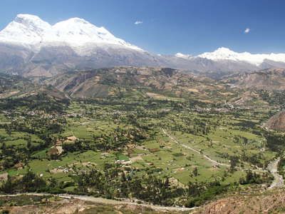 Cordillera Blanca with debris cone of Ranrahirca
 Late afternoon view from the road between Matacoto and Santo Toribio across the Callejón de Huaylas...") Cordillera Blanca | Nevado Huascarán
Cordillera Blanca | Nevado Huascarán View from the road between Matacoto and Santo Toribio across the Callejón de Huaylas in E direction...") Cordillera Blanca | Nevado Huascarán at sunset
Cordillera Blanca | Nevado Huascarán at sunset View from the slopes of the Cordillera Negra to the highest tropical mountain worldwide (6768 m). Th...") Callejón de Huaylas with Nevado Huascarán
Callejón de Huaylas with Nevado Huascarán View from the slopes of the Cordillera Negra to the highest tropical mountain worldwide (6768 m). Th...") Callejón de Huaylas with Nevado Huascarán
Callejón de Huaylas with Nevado Huascarán Nueva Yungay (left portion of the image) was founded after the original town had been destroyed by a...") Callejón de Huaylas | Nueva Yungay and Campo Santo
Callejón de Huaylas | Nueva Yungay and Campo Santo Campo Santo represents the site of the original town of Yungay, which was destroyed on 31 May 1970 w...") Yungay | Campo Santo
Yungay | Campo Santo View from the cemetery hill in NE direction. Campo Santo represents the site of the original town of...") Yungay | Campo Santo with Nevado Huascarán
Yungay | Campo Santo with Nevado Huascarán Various crops are cultivated at an elevation of approx. 3200 m asl. between Yungay and the Lagunas d...") Huashao | Farmland
Huashao | Farmland View from the Ishinca Trek in SW direction") Quebrada Ishinca and Cordillera Negra
Quebrada Ishinca and Cordillera Negra View from the rooftop of the Universidad Nacional Santiago Antúnez de Mayolo (UNASAM) over the city...") Huaraz | City centre
Huaraz | City centre View from the rooftop of the Universidad Nacional Santiago Antúnez de Mayolo (UNASAM) in E directio...") Huaraz | Urban landscape
Huaraz | Urban landscape View from the slopes of the Cordillera Negra over Huaraz in E direction to the valleys of the Quilca...") Huaraz with Cordillera Blanca
Huaraz with Cordillera Blanca View from the slopes of the Cordillera Negra over Huaraz in E direction to the valleys of the Quilca...") Huaraz | Panoramic view with Cordillera Blanca
Huaraz | Panoramic view with Cordillera Blanca Panoramic view from the trail to Laguna Churup across the Callejón de Huaylas with Huaraz in SW dir...") Callejón de Huaylas with Huaraz and Cordillera Negra
Callejón de Huaylas with Huaraz and Cordillera Negra Panoramic view from the trail to Laguna Churup across the Callejón de Huaylas with Huaraz in W dire...") Quebrada Quilcayhuanca with pine plantation
Quebrada Quilcayhuanca with pine plantation View from the trail to Laguna Churup across the Callejón de Huaylas with Huaraz in SW direction to ...") Callejón de Huaylas with Huaraz and Cordillera Negra
Callejón de Huaylas with Huaraz and Cordillera Negra Panoramic view from the trail to Laguna Churup across the Callejón de Huaylas in NW direction to th...") Callejón de Huaylas | Mina Pierina
Callejón de Huaylas | Mina Pierina View from the trail to Laguna Churup across the Quebrada Quilcayhuanca in SE direction. The glacieri...") Quebrada Quilcayhuanca and Cashan
Quebrada Quilcayhuanca and Cashan In the Cordillera Blanca, trees of the genus Polylepis can survive at 4500 m asl. or even higher. Wh...") Quebrada Quilcayhuanca | Polylepis
Quebrada Quilcayhuanca | Polylepis View from the highway Pativilca - Huaraz across the uppermost part of the Callejón de Huaylas in SE...") Conococha | Río Santa and Cordillera Huayhuash
Conococha | Río Santa and Cordillera Huayhuash View from the highway Pativilca - Huaraz in E direction. This lake at slightly above 4000 m asl. is ...") Laguna Conococha
Laguna Conococha View from Mirador de Antahuilque in NW (downstream) direction. The Colca Valley has been inhabited s...") Valle del Colca with Madrigal
Valle del Colca with Madrigal View from Mirador de Wayrac Punku in E (upstream) direction. The Colca Valley has been inhabited sin...") Valle del Colca | Panoramic view with Madrigal
Valle del Colca | Panoramic view with Madrigal View from Mirador de Wayrac Punku in NE direction. This section of the Colca Valley has been influen...") Valle del Colca | Panoramic view with Madrigal
Valle del Colca | Panoramic view with Madrigal View from Mirador de Wayrac Punku in NE direction. This section of the Colca Valley has been influen...") Valle del Colca with landslide of Madrigal
Valle del Colca with landslide of Madrigal View from Mirador de Wayrac Punku in NE direction. This section of the Colca Valley has been influen...") Valle del Colca | Landslide of Madrigal in 2018
Valle del Colca | Landslide of Madrigal in 2018 View from Mirador de Wayrac Punku in NE direction. This section of the Colca Valley has been influen...") Valle del Colca | Landslide of Madrigal in 2022
Valle del Colca | Landslide of Madrigal in 2022 View from Mirador de Wayrac Punku in E (upstream) direction. The Colca Valley has been inhabited sin...") Valle del Colca with terraced farmland
Valle del Colca with terraced farmland View in NW (downstream) direction. The Colca Valley has been inhabited since pre-Incan times, so tha...") Valle del Colca
Valle del Colca View in W (downstream) direction. This massive outcrop of bright, predominantly fine-grained pyrocla...") Valle del Colca with pyroclastic deposit
Valle del Colca with pyroclastic deposit View from Mirador de Antahuilque in NE direction. The Colca Valley has been inhabited since pre-Inca...") Valle del Colca | Panoramic view with Madrigal and Lari
Valle del Colca | Panoramic view with Madrigal and Lari View from Mirador de Antahuilque in NE (upstream) direction. The Colca Valley has been inhabited sin...") Valle del Colca | Panoramic view with Lari
Valle del Colca | Panoramic view with Lari View from Mirador de Antahuilque in E (upstream) direction. The Colca Valley has been inhabited sinc...") Valle del Colca | Panoramic view with Lari and Maca
Valle del Colca | Panoramic view with Lari and Maca The Colca Valley has been inhabited since pre-Incan times, so that ancient terraced farmlands are ch...") Valle del Colca | Terraced farmland
Valle del Colca | Terraced farmland View in N direction. The Colca Valley has been inhabited since pre-Incan times, so that ancient terr...") Valle del Colca | Panoramic view with terraced farmland
Valle del Colca | Panoramic view with terraced farmland View in E (upstream) direction. This section of the Colca Valley has been influenced by earthquakes,...") Valle del Colca | Landslide of Maca
Valle del Colca | Landslide of Maca Panoramic view from the vicinity of Achoma in NE (upstream) direction. The Colca Valley has been inh...") Valle del Colca with Ichupampa
Valle del Colca with Ichupampa View from the Carretera al Colca in N direction down to Chivay and up the Colca Valley") Valle del Colca with Chivay
Valle del Colca with Chivay Panoramic view from the Mirador Puma Uta over the city of Puno in SE direction. The historic centre,...") Puno with Lago Titicaca
Puno with Lago Titicaca View from the Mirador Puma Uta over the N part of Puno in SE direction. The Puno Bay of Lake Titicac...") Puno with Lago Titicaca
Puno with Lago Titicaca View from the Mirador Puma Uta over the city of Puno in SE direction. The historic centre, going bac...") Puno with Lago Titicaca
Puno with Lago Titicaca View from the Mirador Puma Uta over the city of Puno in S direction. The historic centre, going back...") Puno
Puno View from the Mirador Puma Uta over the city of Puno in S direction. The historic centre is shown in...") Puno
Puno View from the Mirador Puma Uta in SE direction") Puno | Residential neighbourhood and Lake Titicaca
Puno | Residential neighbourhood and Lake Titicaca Panoramic view from the Mirador El Cóndor (Mirador de Kuntur Wasi) over the city of Puno and the Pu...") Puno with Lago Titicaca
Puno with Lago Titicaca View from the Mirador El Cóndor (Mirador de Kuntur Wasi) over part of the city of Puno and the Puno...") Puno with Lago Titicaca
Puno with Lago Titicaca View down the stairs connecting the Mirador El Cóndor (Mirador de Kuntur Wasi) with the historic ce...") Puno with historic centre
Puno with historic centre View from Mirador Puma Uta in E direction to the Puno Bay of Lake Titicaca and the peninsula of Chuc...") Lago Titicaca | Bahía de Puno with reed belt
Lago Titicaca | Bahía de Puno with reed belt The Uru people have traditionally used bundles of totora reed (Schoenoplectus californicus) to creat...") Lago Titicaca | Reed harvesting
Lago Titicaca | Reed harvesting View from the highest point of Isla Taquile in SW direction to the peninsula of Chucuito and the Pun...") Lago Titicaca with Península de Chucuito and Puno
Lago Titicaca with Península de Chucuito and Puno View from Mirador El Cóndor (Mirador de Kuntur Wasi) in E direction to the Puno Bay of Lake Titicac...") Lago Titicaca | Bahía de Puno and Cordillera Real
Lago Titicaca | Bahía de Puno and Cordillera Real View from Isla Taquile in E direction to the Bolivian shore of Lake Titicaca and the N part of the C...") Lago Titicaca with Cordillera Real
Lago Titicaca with Cordillera Real Panoramic morning view from the slopes of Pachatata (4085 m) to the SE portion of the island which, ...") Lago Titicaca | Isla Amantaní
Lago Titicaca | Isla Amantaní Panoramic afternoon view over the SE portion of the island which, with a surface area of slightly le...") Lago Titicaca | Isla Amantaní
Lago Titicaca | Isla Amantaní Morning view from Pachatata (4085 m) to the SE portion of the island which, with a surface area of s...") Lago Titicaca | Isla Amantaní
Lago Titicaca | Isla Amantaní Afternoon view over the SE portion of the island which, with a surface area of slightly less than 10...") Lago Titicaca | Isla Amantaní
Lago Titicaca | Isla Amantaní Afternoon view of the SE portion of the island. The Cordillera Real (on the territory of Bolivia) ca...") Lago Titicaca | Isla Amantaní and Cordillera Real
Lago Titicaca | Isla Amantaní and Cordillera Real View from the slopes of Pachamama (4120 m) to Pachatata (4085 m). The island of Amantaní, with a su...") Isla Amantaní | Pachatata
Isla Amantaní | Pachatata Morning view from Pachatata (4085 m) to the W part of the island and to the mainland") Isla Amantaní with Lago Titicaca
Isla Amantaní with Lago Titicaca Taquile Island, with a surface area of 6 square kilometres, rises approx. 250 m above Lake Titicaca....") Isla Taquile | Footpath with stone arch
Isla Taquile | Footpath with stone arch Taquile Island, with a surface area of 6 square kilometres, rises approx. 250 m above the lake. Its ...") Isla Taquile with Lago Titicaca
Isla Taquile with Lago Titicaca View along the W coast of Taquile Island in S direction. With a surface area of 6 square kilometres,...") Lago Titicaca with Isla Taquile
Lago Titicaca with Isla Taquile View from the highest area of the island in S direction. With a surface area of 6 square kilometres,...") Lago Titicaca | Isla Taquile
Lago Titicaca | Isla Taquile The national flower of Peru also grows on Taquile Island.") Isla Taquile | Cantua buxifolia
Isla Taquile | Cantua buxifolia Flight Cusco - Lima, view over Pachatusan (4842 m) and the valley of the Río Urubamba (also known a...") Cusco | Pachatusan and Cordillera Urubamba
Cusco | Pachatusan and Cordillera Urubamba Flight Cusco - Lima, view down the valley of the Río Urubamba (also known as Río Vilcanota, headwa...") Cusco | Pachatusan and Urubamba Valley
Cusco | Pachatusan and Urubamba Valley Flight Cusco - Lima, view over the city of Cusco in W direction to the Cordillera Vilcabamba with Ne...") Cusco with Cordillera Vilcabamba
Cusco with Cordillera Vilcabamba Flight Cusco - Lima, view over the city of Cusco in SW direction") Cusco
Cusco Flight Cusco - Lima. The airport of Cusco was once built at the edge of the city. Over time, it beca...") Cusco with Aeropuerto Alejandro Velasco Astete
Cusco with Aeropuerto Alejandro Velasco Astete Flight Cusco - Lima, view in SW direction to the city of Cusco with its historic centre and the Inca...") Cusco with historic centre and Sacsayhuamán
Cusco with historic centre and Sacsayhuamán Flight Cusco - Lima, view over the the city of Cusco with its historic centre and the Inca fortress ...") Cusco | City centre
Cusco | City centre Flight Cusco - Lima, view in S direction to the Inca fortress Sacsayhuamán and the historic centre ...") Cusco | Sacsayhuamán and historic centre
Cusco | Sacsayhuamán and historic centre View from Cristo Blanco over part of Cusco in SW direction, with some hillslope neighbourhoods shown...") Cusco with hillslope neighbourhoods
Cusco with hillslope neighbourhoods View from the bell tower of Iglesia de San Cristóbal in SE direction, with the slogan \"Viva El Peru...") Cusco | Patriotism
Cusco | Patriotism The salt evaporation ponds in this small tributary valley to the Urubamba Valley (in the right backg...") Salineras de Maras | Panoramic view
Salineras de Maras | Panoramic view View from the vicinity of the Salineras de Maras in NW direction down to the Urubamba Valley and to ...") Urubamba Valley with Cordillera Urubamba
Urubamba Valley with Cordillera Urubamba Morning view from the Sky Lodge at Soraypampa to the glacierized Humantay massif with Tukarway (5928...") Cordillera Vilcabamba | Soraypampa with Tukarway
Cordillera Vilcabamba | Soraypampa with Tukarway View down the upper section of Quebrada Humantay in NW direction. On 23 February 2020, a large lands...") Quebrada Humantay with GLOF impact area of 2020
Quebrada Humantay with GLOF impact area of 2020 View from the highway A1 (Bruce Highway)") Gin Gin | Cattle grazing
Gin Gin | Cattle grazing View from the Inkerman Lookout towards northwest") Ayr | Cultural landscape mosaic
Ayr | Cultural landscape mosaic View from the Inkerman Lookout towards northwest") Ayr | Cultural landscape mosaic
Ayr | Cultural landscape mosaic View south to Saint-Pierre, surrounded by sugar cane fields and the Indian Ocean. Sugar cane is grow...") Saint-Pierre
Saint-Pierre View over the sugar cane fields towards southeast to the Indian Ocean. The village at the lower left...") Saint-Pierre | Sugar cane cultivation
Saint-Pierre | Sugar cane cultivation Location: near the Aérodrome Saint-Pierre-Pierrefonds. Sugar cane is cultivated in many places alon...") Saint-Pierre | Sugar cane cultivation
Saint-Pierre | Sugar cane cultivation View over the sugar cane fields towards west. Sugar cane is cultivated in many places along the coas...") Saint-Louis with Rivière Etienne
Saint-Louis with Rivière Etienne View towards northwest to the slopes of the ancient shield volcano shaping most of the island. The B...") Entre-Deux | Panorama of volcanic slopes
Entre-Deux | Panorama of volcanic slopes View towards north into the Cirque de Cilaos. The river draining the cirque is the Bras de Cilaos, t...") Outlet of Cirque de Cilaos
Outlet of Cirque de Cilaos Sunset view from La Souris Blanche to the 170 m high bridge. The Route des Tamarins is part of the m...") Route des Tamarins | Viaduc de la Grande Ravine
Route des Tamarins | Viaduc de la Grande Ravine View towards southwest. Saint-Paul is seen in the foreground and centre of the image, the peninsula ...") Saint-Paul and Cap de la Houssaye
Saint-Paul and Cap de la Houssaye View from the trail leading up to the Roche Verre Bouteille towards northwest") Dos d'Ane
Dos d'Ane View from Le Grand Bord across the Cirque de Mafate with the village of Marla towards east. The Gros...") Gros Morne and Piton des Neiges
Gros Morne and Piton des Neiges View from Le Grand Bord across the Cirque de Mafate towards north. La Nouvelle is seen in the left, ...") Cirque de Mafate with Gros Morne and Piton des Neiges
Cirque de Mafate with Gros Morne and Piton des Neiges View across the Cirque de Cilaos with the town of Cilaos towards southeast. The Piton de la Fournais...") Cirque de Cilaos
Cirque de Cilaos View across the Cirque de Cilaos towards south. The town of Cilaos appears in the left centre of the...") Cirque de Cilaos
Cirque de Cilaos View from Reposoir towards south") Cirque de Cilaos with Bras de Cilaos
Cirque de Cilaos with Bras de Cilaos View from Sentier Burel") Cirque de Cilaos | Farmstead
Cirque de Cilaos | Farmstead View from the summit area of Piton des Neiges across the Cirque de Cilaos with Cilaos in southern di...") Cirque de Cilaos | Panoramic view
Cirque de Cilaos | Panoramic view View from the summit area of Piton des Neiges southeast. Piton de la Fournaise (2632 m) is seen in t...") Cirque de Cilaos | Panoramic view
Cirque de Cilaos | Panoramic view View from the summit area of Piton des Neiges towards southeast. Piton de la Fournaise (2632 m) appe...") Piton de la Fournaise
Piton de la Fournaise Morning view from near Nez de Boeuf across the Plaine des Cafres towards northwest to the Piton des ...") Plaine des Cafres and Piton des Neiges
Plaine des Cafres and Piton des Neiges View from near Nez de Boeuf across the Plaine des Cafres towards northwest to the Piton des Neiges (...") Plaine des Cafres and Piton des Neiges
Plaine des Cafres and Piton des Neiges View across the Plaine des Cafres towards northwest. The rim of the Cirque de Cilaos with the Piton ...") Plaine des Cafres and Piton des Neiges
Plaine des Cafres and Piton des Neiges View from the Route du Volcan. Cattle farming is a very common occupation on the Plaine des Cafres.") Plaine des Cafres | Cattle
Plaine des Cafres | Cattle View towards south (downstream)") Rivière des Remparts
Rivière des Remparts A typical landscape of central Sri Lanka") Hettipola | Rice cultivation
Hettipola | Rice cultivation A typical landscape of Sri Lanka's North Central Province, dominated by rice fields") Palatiyawa | Rice cultivation
Palatiyawa | Rice cultivation View from the Mahiyangane-Dimbulagala-Dalukkane Highway to a stream passing through the landscape of...") Palatiyawa | Small stream
Palatiyawa | Small stream Whereas the slope in the foreground is used as a tea garden (Sri Lanka is one of the major tea-expor...") Knuckles Mountain Range with Midlands Tea Estate
Knuckles Mountain Range with Midlands Tea Estate View over part of the central highlands of Sri Lanka") Ramboda with central highlands
Ramboda with central highlands Rice terraces are common landscape features throughout southern and southeastern Asia.") Ramboda | Rice cultivation
Ramboda | Rice cultivation Sri Lanka is one of the major tea-exporting countries worldwide. The relatively cool and humid clima...") Nuwara Eliya | Labookellie Tea Estate
Nuwara Eliya | Labookellie Tea Estate View from the road to Horton Plains over Sri Lanka's central highlands") Central highlands panorama
Central highlands panorama View from Little World's End in southern direction to the Nanperil Tea Estate") Horton Plains NP | World's End
Horton Plains NP | World's End The coconut palm (Cocos nucifera) is native to tropical coastal areas worldwide. Parts of the plant ...") Tangalle | Coconut palm grove
Tangalle | Coconut palm grove Location: near the road between Butiaba and Fort Portal") Western Uganda | Slash and burn
Western Uganda | Slash and burn Location: near the road between Butiaba and Fort Portal") Western Uganda | Farmstead
Western Uganda | Farmstead Road between Butiaba and Fort Portal") Western Uganda | On the road
Western Uganda | On the road Location: near Rwankezi. This photograph transports a highly stereotypical view people from outside ...") Western Uganda | Banana transport
Western Uganda | Banana transport Location: near Rwankezi. This photograph transports a highly stereotypical view people from outside ...") Western Uganda | Banana transport
Western Uganda | Banana transport Road between Fort Portal and Kasese crossing the valley of the Rwimi River") Western Uganda | Road construction
Western Uganda | Road construction View from near Katara towards west to Lake Edward in the Western (or Albertine) Rift.") Western Rift | Escarpment
Western Rift | Escarpment") Jinja | Farmstead
Jinja | Farmstead Kakira Sugar Works is the most important employer in the area of Jinja and the largest manufacturer ...") Kakira Sugar Works
Kakira Sugar Works Kakira Sugar Works is the most important employer in the area of Jinja and the largest manufacturer ...") Kakira Sugar Works
Kakira Sugar Works View from the road between Jinja and Busia") Eastern Uganda | Rice cultivation
Eastern Uganda | Rice cultivation